.

Sunday, August 31, 2008

Hurricane Gustav response, August 31

3:54 p.m. MT

Additional resources have been ordered today so that they can be staged ready to be deployed as needed after the hurricane makes landfall:
  • Both Southern Area Type 1 Incident Management Teams (IMT): Quesinberry (Blue) and Ruggiero (Red)
  • One Type 2 IMT
  • The Texas Lone Star State IMT is being staged at College Station.
  • Five local jurisdiction Texas Type 3 IMT's are also being staged at College Station
  • Two Buying Teams to be staged in Arkansas and Georgia
  • Eight Type 2 crews
This is in addition to the resources Wildfire Today reported yesterday, three NIMO teams and FEMA resources including Incident Management Assistance Teams (IMAT) and an Advanced Emergency Response Team (ERT-A).

The Southern Geographic Area has increased their preparedness level to Four. The Mississippi coordination center has closed in anticipation of the hurricane and the Louisiana center will close by noon tomorrow. Texas will assume the duties of the Louisiana center.

The computer models at noon MT today are predicting Gustav will remain a category 3 storm as it moves rapidly across the Gulf and should make landfall west of New Orleans around mid-day on Monday. It is moving too quickly to pick up much additional energy from the warm waters after unexpectedly losing much of it's punch while transiting across Cuba. After landfall it's a little uncertain, but it will most likely slow down and meander around east Texas for a while, probably causing widespread flooding.

Wildfire news, August 31

More about the fatal Boise fire

The local newspaper is providing more analysis of Tuesday's fire in Boise that destroyed 10 houses, damaged many more and killed Mary Ellen Ryder.
As soon as the first houses caught on fire, the still-burning grasses were nearly irrelevant. From then on, the trees, shrubs and wooden roofs within the subdivisions became the fuels for the fire, and the wind direction and ability of the local firefighters to respond determined which houses would survive.

The Oregon Trail Fire showed that in a dense urban-wildland interface, it may not be enough that a few individual homeowners do all the right fire-safe things. If one neighbor doesn't, every home could be in danger.

A collaborative program called "firewise" and state and city codes have evolved in the years since a wildfire burned through Oakland, Calif., neighborhoods in 1991. The guidelines recommend residents remove fuel, such as dead grass, and other entry points, including cedar-shake roofs, that bring wildland fires into urban landscapes.

But the rules are voluntary, and if a few people decide not to participate, an entire subdivision can be threatened.

The above is from the Idaho Statesman
This is consistent with the Wildfire Today story from July 23:

Researchers determined that of the 199 homes destroyed in last October's Grass Valley fire near Lake Arrowhead, California, only 6 of them were directly hit by the fire. The other 193 homes ignited and burned due to surface fire contacting the home, firebrands accumulating on the home, or an adjacent burning structure. The report, by Jack Coen and Richard Stratton, concludes:
In general, the home destruction resulted from residential fire characteristics. The ignition vulnerable homes burning in close proximity to one another continued the fire spread through the residential area without the wildfire as a factor. This implies that similar fire destruction might occur without a wildfire. A house fire at an upwind location at the same time and under the same conditions as the wildfire could have resulted in significant fire spread within the community.
The complete report can be found HERE. Links to other reports by Jack Cohen on similar subjects are HERE.

BLM provides satellite phones to ranchers

In southwest Idaho there are large gaps in cell phone coverage, making it impossible to quickly report new lightning fires. The Bureau of Land Management and the Idaho Bureau of Homeland Security are supplying satellite phones to some ranchers in very remote areas. Here is an excerpt from an AP article:
A year ago, however, wildfires blazed across 3,000 square miles of Idaho — an area three times the size of Rhode Island.

It took three weeks to contain one of those wildfires, a lightning-caused complex of blazes that covered nearly 1,000 square miles, killing wildlife and livestock, blackening grazing ground and charring habitat for seasons to come for sensitive species such as sage grouse. It was the largest single fire ever fought by the BLM in Idaho. As the embers were barely cool, BLM managers and ranchers began discussions last fall about improving communication before the next conflagration.

For an initial agency investment of $10,000, the seven Iridium satellite phones seemed a reasonable bargain, said Janet Peterson, the BLM's safety manager in Boise — especially considering that 1,000-square-mile complex alone cost more than $13 million to fight and will likely set taxpayers back $34 million more to restore the blackened landscape.

"The ranchers are a pretty key partner," she said. "They know the country."

Should one of Idaho's cowboys spot a fire and place a call, firefighting planes could be scrambled out of the Boise Airport about 50 miles northeast of Silver City. The ranchers have been told to use the phones in medical emergencies, too. The state's disaster agency, the Idaho Bureau of Homeland Security, is chipping in for the service costs.

"If you see a fire and have no connectivity, you can't tell anybody," said Col. Bill Shawver, the agency's director. "To have a satellite phone with you, you can make that immediate call and get firefighters mobilized."

The phones were distributed to ranchers based on where they run their cattle and the existing grid of cell phone service. Cowboys call in once a month, to make sure the phones are working.

Saturday, August 30, 2008

Hurricane Gustav response

Update at 7:30 p.m. MT, Saturday, Aug. 30

Here are the hurricane models as of 6:00 p.m. MT today that predict the track for Gustav:


=======================================================

As of 3:45 p.m. MT the hurricane has increased to a Category 4 storm, just shy of Cat. 5, and after it crosses Cuba is expected to reach Cat. 5 Cat. 4 status as it moves across the Gulf of Mexico. The forecast models still call for it to make landfall in the Louisiana area around mid-day on Monday.

Three National Incident Management Organization (NIMO) teams are being pre-positioned. Whitney's and Cable's teams will be staged in Dallas, and Custer's will be in Atlanta. The National Park Service has activated one of their All Hazard teams to report to Jacksonville.

FEMA has deployed Incident Management Assistance Teams (IMAT) to Louisiana, Mississippi and Texas. An Advanced Emergency Response Team (ERT-A) has been deployed to Alabama and a "Warm Cell”" team is already active in the Louisiana Emergency Operations Center. FEMA has ordered 18 urban search and rescue teams, including one from Liverpool, England, as Firegeezer reports.

They have the following supplies and equipment already pre-positioned:
  • More than 2.4 million liters of water (137 truckloads).
  • More than 4 million meals (203 truckloads).
  • 478 emergency generators.
  • 141 truckloads of tarps.
  • 267 truckloads of blankets and cots.
Organizations in Texas are making preparations:
The U.S. Forest Service is working with FEMA and has placed personnel in the FEMA Region VI headquarters in Denton, Texas in addition to several planning personnel at the State Operations Center in Austin. Texas Forest Service has received several assignments from the GDEM. The Lone Star State Incident Management Team has been activated and is awaiting instructions for deployment. Five Type III local government teams, led by TFS personnel, have also been activated. TFS aviation personnel have been requested to Galveston Island to assist with the possible airlift of patients from the University of Texas Medical Branch this weekend.
HERE is a link to a satellite loop that shows Gustav moving across Cuba. It is expected to rebuild over the warm Gulf of Mexico waters to Cat. 5 strength and head toward Louisiana.

Some hurricanes originate over the continent of Africa. This photo from WeatherUnderground on Thursday shows easterly waves moving from east to west that may develop into tropical storms or hurricanes after they move off the coast of Africa. If some of them do, the next week or two are going to be busy in the Atlantic.

Wildfire news, August 30

Gunbarrel fire update

This fire between Yellowstone National Park and Cody, Wyoming has not made any major advances in the last couple of days. It has burned 61,433 acres and is being managed as a Confine/Contain fire. Paul Broyles' Type 1 Incident Management Team reports this morning:
Yesterday's Activity
Fire activity was again moderate with little perimeter growth. Most of the active fire behavior was in the Jim Creek and Trout Creek areas where the fire burned out some interior pockets of bug-killed trees. Firefighters successfully burned out an area between Elephant Head and Goff Lodges and secured fire lines in the vicinity of Star Hill Ranch. The northeastern flank of the fire advanced up the Robbers' Roost Creek Drainage some distance, but remains several miles east of the Rattlesnake and Dead Indian Creek drainages.

Today's Planned Activity
Firefighters will focus efforts on securing fire line in the Robbers' Roost Creek drainage to stop its northward spread. Crews will mop-up and finish securing fire lines near Elephant Head and Goff Lodges and the Star Hill Ranch. Structure protection efforts will remain in place in all areas of the fire as needed. Helicopter support will aid their efforts as wind conditions permit. Crews will begin retrieving pumps and hoses from areas of the fire where they are no longer needed and will be available for initial attack response.

Today's Forecasted Weather
Temperatures: Mid 80's
Humidities: 9-16%
Winds: Out of the southeast at 20-30 mph.

Friday, August 29, 2008

Wildfire news, August 29

Jet Skis used again on a wildland fire

On August 19 Wildfire Today covered the story of a wildland fire in Hawaii where jet skis were used to evacuate tourists. Yesterday the San Francisco Fire Department used jet skis to transport hose from their fire boat to Yerba Buena Island where a fire was burning in an area with difficult access. Yerba Buena Island is in San Francisco Bay near the Bay Bridge.

They used two jet skis each with one firefighter aboard to carry the hose to the island, which had no roads near the three-acre fire.


View Larger Map

Crew finds pipe bomb

Damn. Another thing for crews to be heads up about. Hopefully, this is a very isolated incident. From The Western News in Libby, Montana:
During the course of a chainsaw tree-thinning operation on Swede Mountain this past weekend, U.S. Forest Service personnel saw their efforts come to a halt – and not because of bad weather or malfuctioning equipment. Late on Sunday afternoon in a ravine near Williams Creek, the crew came across a pipe bomb.

“You look at them and have every reason to believe it’s live,” Lincoln County detective Jim Sweet said. “They’re so highly dangerous when they throw them in a ditch like that. If anybody had been near it (if exploded) it could’ve been lethal.”

The bomb was indeed live and by its weathered appearance, could’ve been sitting in that spot for some time. Sweet said the Forest Service crew knew right away what they had found and reported its location.

Through an agreement with Malmstrom Air Force Base in Great Falls, a bomb disposal unit was called in to take care of the device. Not long after arriving on Monday, the unit cleared the scene and soon thereafter exploded the bomb.

Hurricane Gustav response

It may strike in the vicinity of Louisiana on Tuesday morning as a Category 3 hurricane. The Southern Geographic Area has been tasked by FEMA to provide aviation overhead resources to be positioned across the southeast. These resources will be used to help FEMA aviation personnel transport evacuees. So far they have received FEMA Mission Assignments that cover TX, LA, MS, and AL.

61,000 acre fire in Montana

The Great Falls Tribune has more information about the Dunn fire, 40 miles northeast of Billings:
Calmer weather on Thursday allowed firefighters to resume their fight against a central Montana wildfire that has charred an estimated 61,000 acres — or more than 95 square miles.

But crews remained wary as winds picked up late in the day, threatening to again send the Dunn fire racing through dry scrub brush about 40 miles north and east of Billings.

"Right now things are all right, but the winds are getting a little stiff," said fire information officer Dwayne Andrews. "They're working real hard to contain it."

Although the size of the blaze was double a late Wednesday estimate, fire officials said it had not grown significantly in the last 24 hours. They attributed the change to better mapping attained through an aerial survey of the area Thursday morning.

Nine ranch houses were threatened and a bridge along Railroad Creek Road in Yellowstone County was destroyed. No evacuations have been ordered.

Strong winds had caused the blaze to expand rapidly Tuesday and Wednesday through a mixture of grasslands, sage brush and ponderosa pine stands. That forced firefighters to suspend efforts to put it out.

But lighter winds slowed that expansion by Thursday, and crews stepped up their attack on the fire, Andrews said. Winds of 5 to 15 miles per hour were forecast, with gusts possible up to 40 miles per hour.

"It's full bore today," he said. "We've got 25 wildland fire engines working on hot spots."

The front of the east-moving blaze was roughly 5 miles north of Pompeys Pillar National Monument. The monument, on the far side of the Yellowstone River, was not considered threatened.

The Dunn dire started last Friday, possibly by a lightning strike in the Bull Mountains. Crews thought they had contained the blaze at about 600 acres over the weekend, until a burning tree fell across fire lines sometime Monday.

Thursday, August 28, 2008

Wildfire news, August 28

Cause of fatal Boise fire revealed

The cause of 
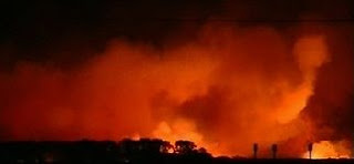
Monday's fire in Boise that burned ten homes, and may have caused the death of one resident, has been determined.
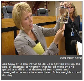
Boise Fire investigators said Thursday that an electrical connection on a powerpole, called a hot tap stirrup, arched causing molten metal to fall to the dry grass below, igniting a wildfire that took only minutes to burn ten homes and damage nine others in a southeast Boise neighborhood Monday.

Lisa Grow, vice president of delivery operations and engineering for Idaho Power, said during the storm that blew through Boise Monday evening, just before 7 p.m. a tree branch fell into a powerline along Boise Avenue about five miles from the fire scene. That caused a break in the power distribution, forcing a stronger current to the hot tap stirrup miles away.

She says the 50 mph winds, plus the extra current, caused the arch that ignited the fire in the Oregon Trail Heights subdivision. The last time the connection was inspected was in 2006. According to Idaho Power, they are inspected every three years.
From KTVB.com

Update: air tanker pilot's injuries minor

Yesterday we covered the crash of the single engine air tanker (SEAT) in northwest Colorado. Thankfully, we can now report that the injuries to the pilot were minor. The SEAT went down at 3 p.m. Wednesday about 20 miles northwest of Meeker, CO. The pilot's name has not been released. The BLM says he walked away from the crash while working on a fire on BLM land and was taken by helicopter to a hospital in Grand Junction.

Ammo depot in Ukraine burns in forest fire

KIEV, August 28--Artillery shells and other ammunition at a storage site in Ukraine exploded after a forest fire spread to the facility, prompting an evacuation, emergency officials say.

The prime minister was quoted as saying nobody was seriously injured.

The Defense Ministry said the fire broke out in a forest near the town of Lozovaya, some 500 kms (300 miles) east of the capital Kiev.

Firefighters couldn't handle the blaze, and it spread to the arsenal, which contains some 100 tons of ammunition on a 1,235-acre (500-hectare) site, it said.

Prime Minister Yulia Tymoshenko said that there were no casualties, adding that 1,400 people had been evacuated and a total of 6,000 would be evacuated from the area around the facility.

Prime Minister Yulia Tymoshenko

About 1,400 people had been evacuated and 6,000 would be evacuated from the area around the facility, officials said.

Lidya, a local resident, said: "They told us on radio and TV we should take documents and personal belongings and leave our houses to wait near bus stops."

"People waited and waited but no transportation was provided. So people started to run, all, including disabled people and old people. I was standing here and saw everything - it was scary, I've never seen anything like that."

Nikolai Tityursky, a spokesman for the Ukrainian armed forces, said: "We have conducted a helicopter reconnaissance flight to detect the locations where the burning process is still under way, where there are still rounds of ammunition that can detonate."

"After the explosions finish, we'll send five tanks to help put out the blaze."

Ukrainian defense officials have warned that dozens of large ammunition depots inherited from the former Soviet Union are poorly maintained and represent a serious public hazard.

A fire and explosions at a munitions depot in southern Ukraine in 2004 killed five people. It took days to put the blaze out.

From Alalam.ir

UPDATE:

Some of the materials in the middle of the fire are 94,000 tons of missiles, 60 tons of propellant explosive, and Luna-M tactical missiles.


File photo of Luna-M missile on transporter.

HERE is a link to a page that has two different videos of the ammo dump burning and exploding.

from the Earth Times:
The nighttime blaze near the town Lozova in Ukraine's Kharkiv province had produced hundreds of detonations so far, threatening firefighters with shrapnel and making quick control of the fire impossible, Ukrainian Prime Minister Yulia Tymoshenko said.

Two storage buildings the Soviet-era artillery shell and rocket dump were burning, and 120-millimetre mortar rounds were detonating "almost every minute" said Viktor Baloga, a government spokesman.

Emergency workers evacuated more than 6,500 residents of Lozova and surrounding villages five kilometres or less from the fire's epicentre.

One military service member was injured as a result of the fire. Windows were broken throughout Lozova and houses damaged as far as three kilometres from the fire, an army spokesman said.

A massive government effort to bring the blaze under control was in progress. Some 200 vehicles and 1,000 firefighting personnel drawn from both the military and civilian sectors were participating, said Volodymyr Shandra, Ukraine Emergency Situations Minister.


USFS diverts funds to cover fire expenses

There are a number of local stories around the nation about the U. S. Forest Service ordering Forests to take money that was planned for other uses to cover massive firefighting expenses. Here is a brief excerpt from one of the stories, this one about the Cleveland National Forest in southern California from the Union-Tribune.
Campground bathrooms and roads in the Cleveland National Forest will suffer because the U.S. Forest Service is cutting at least $400 million in programs nationwide so it has enough money to fight fires in September.

“It's all those types of things that users typically see,” said Brian Harris, a spokesman for the agency in Rancho Bernardo.

National forests in California are on the hook to lose $33 million, and they could give up more if the Forest Service has to battle a massive wildfire. That money would have been used for removal of hazardous trees, roof repairs, new vehicles and other needs.

In the 438,000-acre Cleveland National Forest, the funding hit is estimated at $1.3 million – or roughly 5 percent of the forest's annual budget. The forest, which stretches across San Diego, Riverside and Orange counties, is a major recreation area that gets about 850,000 visits a year.
If you can't get enough of this fiscal stuff, here are more articles about this in other parts of the country: Montana, Oregon, Wyoming & South Dakota, West Virginia, and Colorado.

Gunbarrel fire, west of Cody, Wyoming

From the Powell Tribune
“The winds are just howling,” Clint Dawson said Wednesday, describing the wind’s rate around the Gunbarrel Fire.

Dawson is the zone fire manager for Shoshone National Forest.

In the valley — in the vicinity of the newly-relocated Gunbarrel Fire camp at Buffalo Bill State Park — the wind was gusting to 40-60 mph in the early afternoon on Wednesday. The new incident command camp is just above the reservoir west of Cody.

An aircraft flying over the fire Wednesday reported winds reaching 115 mph at 11,000 feet, Dawson said. (some of the peaks in the fire area are at about 10,000 feet-bg)

The fire was was spotting on the east side of 12,000-foot high Trout Peak, according to an incident report.

Wind often is the rule rather than the exception in the hills and mountains above the reservoir, but Dawson described these fierce winds as “abnormal.”

A red-flag warning was issued for the fire area again on Wednesday. That means low humidity and windy conditions likely will translate to potential fire growth and extreme fire behavior, said Mark Giacoletto, Shoshone Forest fire management officer.

As of Wednesday morning, the Gunbarrel Fire was roughly 10-12 miles west of Cody and north of U.S. 14-16-20. It had grown by 3,424 acres since Monday to a total of 57,384 acres and extended about 24 miles roughly from east to west. Lightning ignited the fire about 38 miles west of Cody on July 26.

At-risk structures on both ends of the fire were being closely monitored and defended by firefighters on the scene.

The price of managing and fighting the fire also is mounting. On Monday, the cost was an even $6.6 million. By Wednesday morning — before Wednesday’s fierce winds — the price tag had grown to a little over $7.6 million.

Members of the Great Basin Type 1 Incident Management Team arrived Tuesday. Official transfer of command occurred Wednesday morning.
Goats gobble grass--and brush

In the 1980's we conducted some experiments using goats for fuel management on the Cleveland National Forest east of Pine Valley, California. They did a fine job of eating all of the grass and almost every leaf on every plant in a brush field. If they were brought back months later, or the following year (or two) the brush would eventually die. This was less risky than prescribed fire in an urban interface area. There were no bulldozers chewing up the ground, and it did not contaminate the air or ground with smoke or pesticides.

But goat-proof fences and drinking water had to be in place, and usually a goat-herder had to remain on site, so it was a high-maintenance operation.

In the last few years fuel management by goats has become more popular. The News Review has an article about a goat-herding family. Here are some excerpts.
Terry and Vera Adams waded through a small sea of Billy goats at their Corning ranchette last week, trying to think of just exactly how many of the animals they own.

All summer long, most of the herd—their female (nanny) goats and babies (kids)—have been on the go, transported from location to location throughout Northern California, eating down grasses, weeds, brush and other vegetation. Counting the male goats surrounding them in a large fenced pasture back at the couple’s home, they figured their stock is up to about 1,400-or-so animals.

It’s been a good year for T&V Livestock, the Adams’ family-run business that contracts with private landowners and public agencies in need of vegetation control. And with today’s focus on health and the environment, they’re bound to get busier.

“The public really goes for it. They like the idea of no sprays and burning,” said Terry of his goats (and a few sheep). “It’s a pretty environmentally friendly way of doing things.”

Dale Shippelhoute of the U.S. Fish and Wildlife Service agrees, which is one of the reasons he contracted with the couple to bring the animals to several federally owned properties over the summer.

Currently, goats are chomping their way through vegetation at the Stone Lakes refuge just 10 miles south of Sacramento, along a wildland-urban interface in Elk Grove. Residents in towns bordering the FWS site have been receptive to the project, which, unlike prescribed burning, doesn’t adversely affect air quality.

Aided these days by their two kids (children, not goats)—Marly, 14, and Terrance, 9—the Adamses have run T&V Livestock for nearly a decade, learning the ins and outs of an operation that is much more complicated than it may sound.

Caring for the creatures means transporting them, along with everything they need to thrive: water, supplements and other supplies. They also have hired help live on site in a trailer and specially trained guard dogs, Anatolian shepherds, to protect them from predators.

Business is strong this year, but Vera says some seasons have been pretty thin. She also warns that goats are tricky to care for; they are susceptible to parasites and cold weather.

While the creatures require a lot of time and effort, Vera insists the family likes having them.

Wednesday, August 27, 2008

Air tanker crashes in Colorado

From Myfoxcolorado:

A firefighting plane battling one of many lightning-caused fires in northwestern Colorado crashed Wednesday, injuring the pilot.

The single-engine air tanker went down at 3 p.m. about 20 miles northwest of Meeker, or 170 miles northwest of Denver.

Bureau of Land Management spokesman David Boyd said the pilot was conscious and able to move. He was flown by helicopter to a hospital in Grand Junction. The pilot's name was not released.

The cause of the crash was under investigation, Boyd said. The pilot was working on a small blaze called the Flat Bush fire that was reported Wednesday morning and was burning in pinyon-juniper and sage on BLM land.

It was one of more than 30 lightning-caused fires in northwestern Colorado, the BLM said. Most were estimated at less than an acre in size. There have been no reports of damage to the 30 gas wells in the area.

The largest is the 27,000-acre Mayberry fire on BLM and private land about 30 miles northwest of Craig. More than 75 firefighters had contained about 50 percent of the blaze, the agency said. The Prong fire, about 20 miles northwest of Craig, jumped containment lines Tuesday night and grew to 5,150 acres.

Firefighters stopped its growth and were working to secure fire lines Wednesday afternoon, the BLM said.

The Lone fire, burning on BLM and private land about 15 miles north of Elk Springs in Moffat County, was about 75 percent contained. It charred 950 acres.

Crews from Maybell, Meeker, Moffat County, the Colorado State Forest Service, the BLM, the U.S. Forest Service, the U.S. Fish and Wildlife Service and the National Park Service were working together to manage the fires.

Wednesday's crash was the second wreck of a firefighting plane in Colorado this year.

In April, firefighting pilot Gert Marais of Fort Benton, Mont., was killed when his single-engine plane crashed after dumping fire-retardant slurry on a wildfire in a remote part of Fort Carson. Marais worked for a Sterling company that supplies aerial firefighting services to the state Forest Service.

Subway hell

I'm glad I don't have to ride this subway every day.


It's good that the officers were there to help.

Wildfire news, August 27

Salvage logging, yes or no?

There is quite a debate going on in the comments section in response to an opinion piece on Redding.com which quotes sections of an article on "Science Daily", titled "Salvage Logging, Replanting Increased Biscuit Fire Severity". Some people are questioning the "science" behind the "Science Daily" article.

The graduate student who authored the Science Daily article was quoted as saying, contrary to conventional wisdom:
Typical fuel treatments such as thinning do not have much effect on fire risk in young forests, Thompson said. There are ongoing experiments within the Biscuit Fire region to test the effectiveness of fuel breaks for slowing the spread of severe fires.
From the Redding.com piece:
According to an article published on June 12, 2007, in Science Daily, salvage logging may not be the best activity to protect our forests. A study conducted by the Oregon State University Department of Forest Science examined the effects of salvage logging in Oregon forests after fires. The study reported that in the past, forest managers assumed that removing dead trees would reduce fuel loads and planting conifers could hasten the return of fire-resistant forests.

What the analysis in this study revealed is that, "after accounting for the effects of topography, Silver Fire severity and other environmental variables, the Biscuit Fire severity was higher where they had done salvage logging and planting."
Thanks to Bob for the tip.

Steve Arno receives award from SAF

Steve Arno, retired from the Forest Service's Rocky Mountain Research Station in Missoula and author of five books, is the pre-eminent wildfire ecology expert in the Northern Rockies, according to the Society of American Foresters. They are giving him one of seven Barrington-Moore Memorial awards this year for accomplishments in wildfire ecology and biological research.

Here is an excerpt from an article in the Missoulian:
Arno and other foresters say they're making progress in educating the West's burgeoning human population about fire's benefits, but it's a never-ending task as the number of newcomers continues to grown.

“Ever since Earth Day in 1970, there's been this back to the land movement and a lot of people saying, ‘Every tree is sacred' and ‘I want it natural,' ” he said.

“They have this pristine idea of what nature is, but it's all based on the erroneous belief that nature doesn't need managing. They really have no idea of what natural is. We're winning more and more people over to the idea of managed forests, but it's like baling out a boat that's taking on water - you have to keep at it.”

Arno has been busy since he retired from the Forest Service's Rocky Mountain Research Station in Missoula. His books include ” Flames in Our Forest” and “Mimicking Nature's Fire,” which looked at the historic role of wildfires in Western forests and how to restore the natural role of fire.
Thanks to Dick for the tip.

Gunbarrel fire

Pushed by strong winds yesterday the fire grew by a couple of thousand acres and 100 people yesterday as Paul Broyles' Type 1 incident management team assumed command and ramped up to handle the increased fire activity. They had to move the incident command post to accommodate the additional personnel, never a fun thing to do, relocating to Buffalo Bill State Park nine miles west of Cody, Wyoming on Highway 14-16-20.

The strategy of the fire has changed from Fire Use to Confine/Contain. Yesterday firefighters completed a burnout above the Elephant Head Lodge, while today they expect to be busy defending homes in the upper portions of the Jim Mountain, Jim Creek, and Big Creek areas, as well as cabins and lodges on the fire’s west end, in the Libby Creek area. The fire has now consumed 57,384 acres.

Firefighters apply foam and install sprinklers at Goff Creek Lodge, August 26. Photo by Michael Johnson.

Professor's body found in burned Idaho home

Wildfire Today covered this yesterday, but now the body has been identified as that of Mary Ellen Ryder.


Mike Quinno watched the Oregon Trail Fire race through a quarter-mile of dry grass toward his house on Sweetwater Drive in seconds.

He stood on his deck Monday night, set back a few feet from the rim of the steep ridge that dropped into the grass and sagebrush flats. Fire burns fastest when it burns uphill. When the wind-driven blaze reached the bottom of the ridge, the flames exploded.

"The fire flew up over my head," Quinno said.

A dozen houses along the rim to the north, Pete Ryder was watching "Monday Night Football" with his wife, Mary Ellen, when he saw smoke in his backyard at 3594 Immigrant Pass Court. When he went outside to check, his backyard erupted in flames so sudden and intense he couldn't get back inside.

In seconds, flames surrounded his home, forcing Ryder to the end of his driveway. His wife was nowhere to be seen.

"When I got to the front of the house and didn't see her, I didn't think she got out."

Mary Ellen Ryder was the one fatality in a fire that destroyed nine homes in the Oregon Trail Heights subdivision and another in the adjacent Columbia Village in Southeast Boise. It also damaged nine other homes on the Bench.

The speed of the fire, the fierce winds and the location, landscaping and construction of the houses helped make it one of Boise's worst fires ever.

The fire did not catch Boise firefighters unprepared.

They had pre-planned how to fight a fire in the area, said Dennis Doan, Boise fire chief. They arrived at Sweetwater Drive within two minutes of the first call. By then, two houses were ablaze.

"From the minute they caught on fire, it was only seconds until the next house," Doan said. "The flames were laying sideways all the way across the street with multiple houses on fire."

Firefighters risked their lives to "draw a line" between the burning houses and the rest of the more than 1,000 homes in the subdivisions near Columbia Village, he said.
The rest of the story is HERE.
Photo courtesy of Idaho Statesman

Fire in the heart of Redding

A vegetation fire in Redding, California burned 130 acres and caused evacuations near the Sacramento River.

North winds gusting up to 30 mph pushed the flames near homes, apartments, condominiums, and an elementary school where classes were in session.


Helicopter pilot spots arsonist
A helicopter pilot dropping water on a wildland blaze Friday in the Mendocino National Forest in northern California spotted a man in camouflage clothing starting a fire.

The helicopter immediately suspended firefighting operations and called law enforcement officers to the scene, who were already nearby getting ready to conduct marijuana eradication operations.

U.S. Forest Service rangers and Mendocino County sheriff's deputies located the man close to the origin of the fire and took him into custody on suspicion of arson.

He was identified as a resident of Mexico, but not named in a forest service press release.

Evidence found on the man indicated he was associated with marijuana cultivation in the area. He admitted starting the fires, but said others were with him.

The Island Fire charred about 50 acres, and was brought under containment at 6 p.m. Saturday.

Officials are conducting an investigation into the fire, and looking for others who may have been working with the man arrested Friday.
Body found in Southern California brush fire

After firefighters suppressed a 4-acre fire near Malibu last night, they noticed a vehicle in the fire and upon further investigation, found a dead body inside. Detectives were sent to investigate the circumstances of the man's death.

About a half-hour later a fire broke out at the same location that consumed about a quarter-acre of brush before being doused by city and county firefighters.

Tuesday, August 26, 2008

Wildfire news, August 26

Callabasas, Calif: Classic urban interface fire

It only burned 30 acres, but when firefighters stopped this fire near Mailbu Creek State Park in southern California this afternoon, it had structures on the perimeter and an island of them in the center. The reports we have seen do not mention any homes being destroyed. This is amazing. From looking at the photo below, a lot of credit should go to the firefighters who had urban interface almost everywhere on this fire, and the homeowners who must have had good clearance as well.

Between 225 and 250 firefighters worked on the fire, along with 5 water dropping helicopters.


East Slide Rock Ridge fire, northeast Nevada

This fire started on August 8 and was managed as a Fire Use fire until August 23 when it was declared a suppression fire and Paul Summerfelt's Type 1 incident management team assumed command. Monday morning it was 18,250 acres but it made a huge run later in the day. Pushed by strong winds in front of a cold front it grew by over 9,000 20,000 acres and is now mapped at 28,000 38,600 acres. It burned towards the northeast and crossed the Humboldt-Toiyabe National Forest boundary in three places onto private land. It has now approached to within 2 miles of the Idaho border.

Gunbarrel fire

Paul Broyle's Type 1 Incident Management Team will assume command from the Fire Use Management Team on Wednesday. This fire which is between Yellowstone National Park and Cody, Wyoming is now 55,471 acres. It is 24 miles (east/west) by 10 miles (north/south). HERE is a link to a map of the fire.


From the incident management team at 8:00 a.m. MT this morning:
Firefighters are anticipating Red Flag conditions today. The warning was extended by the National Weather Service until 6:00 pm today for high winds. Strong dry winds predicted today, coupled with continued warm and dry conditions, are expected to increase fire growth on the northeast side of the fire today. Structure protection is in place for residences and firefighters expect to be busy defending homes in upper portions of the Jim Mountain, Jim Creek, and Big Creek areas; and cabins and lodges on the fire's west end in the general area of Libby Creek.

Yesterday the fire made advances in the Goff Creek and Gunbarrel Creek drainages where structure protection is in place. Due to the potential for the fire to spread towards Elephant Head Lodge, the lodge was placed under an evacuation advisory. The fire also grew on the east side, spotting onto the east side of Trout Creek.

An update from the incident management team at 11:30 a.m. MT this morning:
Currently wind on the Gunbarrel fire is blowing at sustained speeds of 15-20 mph, with gusts to 30-40 mph. A cold front is passing over the northwest corner of Wyoming this morning.

The wind is causing the fire to spread very readily. Spot fires thrown ahead of the fire front are among the most challenging consequences of the strong wind.

The fire is very active in its northeast corner, in Trout Creek. Managers believe it is likely this edge of the fire may move a few miles today. There is also significant fire activity in the head of Big Creek. Last night the fire was most active in Libby Creek; this area is more sheltered from upper level winds than the fire’s east end, but still is expected to be challenging today.

Firefighters are working in each of the areas where fire is close to homes. They include Elephant Head Lodge, Star Hill Ranch, Jim Mountain, Mooncrest Ranch, and others.

The wind currently is too strong for fixed wing air tankers to fly, and too strong for all but the two largest helicopters. An aerial observer is having a turbulent day today but so far still is able to fly safely.

The red flag warning for strong wind remains in effect until 6 p.m. this evening.

Body found in burned house at Boise wildfire

Authorities say a badly burned body was discovered by firefighters inside one of the homes damaged or destroyed by a wildfire that swept through a neighborhood on the city's southeast side.

Boise Police Spokeswoman Lynn Hightower says fire crews found the body early Tuesday while combing through one of the 9 homes destroyed by the blaze. Hightower said it's too soon to tell whether the body is that of a woman from the middle-class neighborhood reported missing by relatives as the blaze spread from a vacant field of sage brush up the ridge to the line of homes.

No other residents were injured in the fires, but 17 police officers and at least one firefighter were treated for various injuries at local hospitals.

Hightower says the fire is under control and that residents from the more than 50 homes evacuated Monday night are now being allowed to return.

Strong winds push a wildfire as it burns a house in Boise.

The above is from the Seattle Times

Here is more about the fire, from the Idaho Press, before the body was found in the burned house.
A wildfire fanned by 50 mph winds burned a swath through a Southeast Boise neighborhood Monday evening, destroying 10 homes and damaging nine others.

Authorities evacuated more than four dozen homes in Boise’s Columbia Village area and residents were not expected to be allowed to return overnight. Seven Boise police officers were hospitalized for treatment of smoke inhalation. Officials said a firefighter also suffered a hand laceration. No other injuries were reported late Monday.


Boise police and fire investigators have reported a woman missing from one of the homes destroyed by fire Monday evening on Immigrant Pass Court. No further information on the missing woman was available.
Media

Boise Fire Chief Dennis Doan said the blaze started as a brush fire on Amity Road during a red flag warning, indicating high winds and high heat make conditions ripe for wildfires.

Flames spread up a ridge and initially ignited six homes before jumping a street to burn several more, Doan said. The blaze spread from roof to roof, ignited trees and shrubbery and burned vehicles parked near the homes.

Fire officials issued a general alarm, calling in all Boise fire personnel. Meridian, Kuna, North Ada County and other area firefighters assisted. As of about 11:15 p.m., 41 fire crews were on the scene. Meridian Police, Ada County Sheriff’s deputies and Idaho State Police assisted Boise Police by taking calls throughout the city.

“In 20 years this is the biggest subdivision fire we’ve had,” Doan said. “The winds were just incredible. The firefighters did an amazing job of putting themselves and their hoses between the houses.”

Dispatchers said the fire was reported at 7 p.m.

“We still have an active fire, but we feel we have it contained,” Doan said late Monday night. “We’re trying to get some hot spots out now. This will take all night and into tomorrow.”

Monday, August 25, 2008

Wildfire news, August 25

Russian troops' scorched earth tactics

The Russian army that is "withdrawing" from Georgia is setting fires as they depart.
The withdrawal of the Russian forces is being accompanied by heavy environmental damage all around the country. Areas flown or driven over by Russian troops are being set on fire. As a result, several acres of forest are burning in Borjomi Gorge, as is a kilometres-long stretch of wheat across the Shida Kartli region. On August 24 two explosions took place. Arms and shells the Russians took away from Georgian military bases exploded in Tskhinvali and a gas transport train suddenly caught fire along the Gori-Khashuri sector of the Georgian Central Railway. The police have been unable to say what caused the fire, but according to one version, splinters of the land mines detonated on the military base beside the railway reached the train and when hitting the oil caused the fire.

Fire in Japan causes evacuations

It is not often that you hear about wildland fires in Japan.
TOKYO, Aug. 25 (Xinhua) -- The municipal government of Imabari on Monday ordered the evacuation of 50 households as a wildfire spread as close as 150 meters to their homes, said reports from Matsuyama, capital of Ehime Prefecture.

The conflagration, which broke out in the mountainous area Sunday afternoon, had destroyed some 75 hectares (175 acres) of forest by 11 a.m. (0200 GMT) Monday, said local authorities, adding that there were no immediate reports of casualties or damage to properties.

Firefighters, along with 10 helicopters from the Self-Defense Forces and those from neighboring prefectures, have been fighting the fire since it was reported to the local fire department Sunday evening.

Red Flag warning

It could be an interesting day today in the fire world. Much of the western U.S. will be under a red flag warning today due to the passage of a cold front. Here is an example of a weather forecast for one of the areas, Cody, Wyoming near the Gunbarrel fire.
Southwest wind will increase to 15 to 20 mph with gusts to near 30 mph across Yellowstone National Park...the Absaroka mountains and Cody foothills this afternoon. These winds will combine with very warm temperatures in the 80s and minimum relative humidity of 10 to 15 percent below 8000 feet to produce extreme fire behavior with any new or existing fires. Winds will continue to increase tonight ahead of an approaching cold front with mountain top winds of 30 to 40 mph gusting near 50 mph. These strong winds will likely result in extensive spotting with any existing fires.
The Gunbarrel fire is expecting:
...the fire may move a few miles to the northeast. Structure protection is in place for residences. Firefighters expect to be busy defending homes in upper portions of the Jim Mountain, Jim Creek, and Big Creek areas; and cabins and lodges on the fire's west end in the general area of Libby Creek.

Aircraft use is planned in the morning, but strong winds are likely to ground both air tankers and helicopters by early afternoon.
The red areas on the map are for the Red Flag Warnings. The light beige areas are for a Hazardous Weather Outlook for strong winds. The darker brown areas are for Extreme Fire Danger.

Sunday, August 24, 2008

You Might Be In A Redneck Volunteer Fire Department If....

  • Your department has ever had two emergency vehicles pulled over for drag racing on the way to the scene.
  • You have naked lady mud flaps on your pumper.
  • Your firehouse has wheels.
  • You've ever gotten back and found out you locked yourselves out of the firehouse.
  • You've ever been toned out on an outhouse fire.
  • That outhouse fire was with entrapment.
  • You've ever let a person's house burn down because they wouldn't let you hunt on their ground.
  • At least one vehicle in the firehouse still has decorations on it from the Halloween Parade and it's January.
  • Your personnel vehicle has more lights on it than your house has lights in it.
  • You don't own a Dalmation, but you do have a coon dog named Sparky.
  • You've ever walked through a christmas display and came up with more than 3 new ideas for a light scheme for your truck.
  • Your rescue truck can smoke the tires.
  • Your department's name is misspelled on the equipment.
  • Your engine had to be towed in the last Christmas Parade.
  • Dispatch can't mention your name without laughing.
  • The local news crew won't put your department on TV because you embarassed them last time.
  • You've ever referred to a light bar as sexy.
  • Your defib consists of a pair of jumper cables, a marine battery, and a fish finder.
  • You've ever taken a girl on a date in a pumper.
  • Your pumper has been on fire more times than it has been to a fire.
  • Your pumper smokes more than the house fire.
  • The only time the trucks leave the station is on bingo night.

Wildfire news, August 24

Gunbarrel fire converted to suppression fire

This fire has been burning for almost a month now. It started and is still burning in an area that is nearly impossible for firefighters.... the proverbial "steep, inaccessible terrain". Make that very steep, and throw in massive amounts of bug-killed timber, and you have the definition of a fire that will burn until the snow flies.

The Shoshone National Forest and the incident management teams labeled this a fire use fire from the beginning, but the reality is they have only one option for managing the fire--wait until the fire moves into an area where it is safe for firefighters to do something effective. Until then, they are doing point protection--defending structures, private property, and other man-made improvements.

The season ending weather event for that part of the country typically occurs around mid-September, so they most likely will have several more weeks of weather conducive to fire spread.


As of midnight last night the team changed the official designation of the fire from fire use to suppression. Here is how it was described by the team:
For People Interested in the Paperwork: In response to the fire’s spread to the east last Thursday, incident objectives were reviewed yesterday. They changed only in catching up with the fact that the places being protected as the fire spreads east now include private property as well as cabins and lodges on public land. Objectives are to:
  • Ensure the safety of firefighting personnel and the public.
  • Allow re to play its role in the ecosystem.
  • Minimize fire impacts to improvements and private property.
  • Provide timely and accurate fire education and information to the public.
  • Ensure that interruptions to traffic flow are minimized and coordinated with Park County Sheriff, Wyoming Highway Patrol and other affected agencies.
Smart strategy has been and will continue to be limited to protecting buildings and other things people have built. It is neither safe nor effective to try to stop the fire’s spread directly. The terrain is too steep and complex, the weather is too dry and periodically windy, and there are too many dead trees. Instead, time and money are being focused where they can be useful, near houses and other improvements.
Cost to Date: $6,100,000, or $117/acre
53,000 acres
203 people committed:
  • 5 crews: 2 hotshot crews, 1 hand crew, and 2 fire use modules
  • 4 helicopters
  • 12 engines and 3 water tenders
The map below was current as of August 22, which is the last fire perimeter uploaded by the team. We are looking west, with Yellowstone National Park in the background. The faint green line at the bottom of the image is the national forest boundary. Click on the image to see a larger version.


Why wildland firefighters fight fire

Bill Kettler of the Mail Tribune in Oregon was a firefighter for three seasons 25 years ago. In a very good article, he describes what for him was the attraction. Here is an excerpt:
But there's more to firefighting than the fat pay checks. It's really about fire itself. Scratch a firefighter and you'll likely find someone who's attracted to the flames just like a moth. There's nothing in the ordinary world that matches the sheer power and awesome spectacle of large-scale fire. Nothing like the terrible beauty of a hillside in flames at night.

Nobody stays in wildland fire for long unless that primal connection burns deep inside. There are easier, safer ways to make money than standing in hot ashes on a 100-degree day, chipping away at a smoldering stump with a hand tool.

Besides the money and the attraction of the flames, there's a measure of excitement and intensity in firefighting that I haven't found in any other work. It's about as close to going to war as you can get without the shooting.

The military comparisons are obvious. Firefighters have their uniforms, and there's a chain of command any soldier would recognize. There are hours of boredom in between moments of heart-stopping intensity.

An intense camaraderie develops when you're doing brutal physical work 10 or 12 hours a day with the same people for days on end. When your shift is over, you eat with them and sleep with them, and you watch out for them while they watch out for you.

Like soldiers, firefighters are deployed to a place they've never seen before. Flames crackle a stone's throw away, and smoke drifts across the landscape, obscuring your vision and irritating your eyes until the tears run. Now and then a helicopter buzzes overhead, dropping hundreds of gallons of water just uphill from where you're standing.

Big airplanes lumber in now and then just above the trees, showering purple rain on the fire and sometimes on you and your crew.

Your crew boss is talking on the radio to his bosses, trying to understand what the fire's doing so he can keep you and the rest of his crew safe if the wind and weather change suddenly.

There's a clear sense of purpose in firefighting that's often lacking in other jobs. Firefighters know exactly what they're supposed to do — whether it's dig line, mop up hot spots, or search for tiny spot fires beyond the line.

There's danger, too — stumpholes that can swallow you up, nests of angry yellow jackets, rattlesnakes, rolling rocks, falling trees, smoke from poison oak that can infect your lungs.

Everybody knows the risks and hears about the occasional fatality, but nobody really expects to become a statistic. You're probably more likely to die in your car than on the fireline.

Wildland firefighting isn't supposed to get you killed. It's supposed to give you memories.

More information about the suspect in the Griffith Park fires


SUSPECT: Investigators saw Lintz riding in a group of bicyclists and stopped him for questioning, a fire official said. Lintz stood out because he was not in racing apparel. Photo courtesy of Los Angeles Fire Department


Wildfire Today covered this yesterday, but now more information is available about the person who was arrested for starting at least one of the eight recent fires in Griffth Park in Los Angeles. From the LA Times:
Gary Allen Lintz was spotted by hikers leaving an area near Griffith Park Drive where a slow-moving brush fire broke out shortly after 2 p.m. Saturday, said John Miller, battalion chief for the arson and counter-terrorism unit of the Los Angeles Fire Department.

Undercover arson investigators then observed Lintz riding in a group of bicyclists and stopped him for questioning, Miller said. Lintz stood out because he was not dressed in racing apparel.

"He didn't fit in with the other bicyclers," Miller said.

Miller said that after questioning Lintz, investigators came to believe he had a connection to all eight recent fires. Miller noted, however, that Lintz was arrested only in connection with the Saturday fire.

In February 2007, Lintz was convicted of arson resulting in a structure or forest land fire, according to court records and officials who spoke at Saturday's news conference.

In addition, court records indicate Lintz had at least two convictions on charges of drinking in public, in 2006 and 2007, and a 1996 conviction for trespassing on railroad property.

Villaraigosa thanked the public and law enforcement officials for apprehending Lintz, who is being held in lieu of $75,000 bail.

Lintz was arrested at 3 p.m. and booked into a Los Angeles jail shortly after 5 p.m., according to jail records.

Lintz's arrest came the same day that stepped-up patrols began in the park, less than a week after fire officials said they suspected a single person was responsible for five fires in two hours Aug. 16 and may have had a hand in two previous suspicious fires.

In part because all five blazes began near roadsides, fire officials said earlier this week that they suspected that someone either on foot or bicycle was responsible.

Saturday, August 23, 2008

Wildfire news, August 23

Suspect arrested in another Griffith Park fire

In the past five weeks there have been at least eight suspected arson fires in Griffith Park, on the north edge of Los Angeles. Today there was another one but firefighters and law enforcement officers were ready. They had a number of undercover officers and arson investigators staking out the park and had firefighters staged nearby.

This has been a pattern for the last five weeks that on either Satuday, Sunday, or Monday between 11 a.m. and 2 p.m. that a suspicious fire would start in the park.

The suspect in today's fire, Gary Allen Lintz, was seen leaving the scene of the fire today. He fled on a bicycle and attempted to hide in plain site with a group of bicyclists, but he stood out from the others who were dressed in bike shorts, bike shirts, and helmets. He was caught, arrested, and is being held in lieu of $75,000 bail.

Lintz is on probation after being convicted of arson of a structure in 2007.

Firefighters, assisted by five helicopters, put out the fire and kept it to three acres, helped by the fact that the fire burned into a previous fire and ran out of fuel.

Curtis Jessen fatality

More information is now available about Curtis Jessen who died when he fell from a cliff on a fire in North Carolina on Thursday.
Jessen, of Black Mountain, was working upstream from Big Bradley Falls scouting the fire about 11 a.m. Thursday to make sure it was still contained. Fellow firefighters began to search for him after he failed to communicate for 15 minutes. They found him at the base of a rock cliff.

Jessen started working for the forest division of the N.C. Department of Environment and Natural Resources in 2002. The work combined two of the things he loved most: being in outdoors and helping people, family members said Friday.

“We weren’t worried about him, because we knew that was his passion, and we knew that is what would make him happy,” said Lynn Horton, Jessen’s cousin.

Horton, who grew up with Jessen in North Catawba, said he “had the softest heart in the world” and loved being outside. He was an avid hunter and fisherman.

Jessen decided during high school he wanted to work with the Division of Forest Resources, and received a forestry degree from N.C. State University.

“He wouldn’t be satisfied if he had to be cooped up inside all the time,” Horton said. “He always wanted to be outdoors. That type of job — everybody that does that is aware of the danger at all times. His main focus was doing his job and helping others.”

For the last three years, Jessen rented a mobile home from Louise Reed and her husband, Michael. The Reeds lived across the road from Jessen, who shared his home with a cherished Chesapeake Bay retriever named Sandy.
From the Citizen Times


Gunbarrel fire update

The national forest increased the size of the area that is closed to the public in an effort to prevent another camper being almost entrapped like what happened near Jim Mountain on Thursday. The fire has burned 50,615 acres, at least 1,000 of which are outside the Maximum Manageable Area.

Gunbarrel Fire photo courtesy of Dewey Vanderhoff

Fire-making materials linked to firefighter

From the Sacramento Bee:
Yolo County prosecutors Friday revealed key aspects of their case against a volunteer firefighter accused of setting wildfires in the rural Capay Valley of California.

Robert Eric Eason, 39, from the hamlet of Guinda, sat beside his lawyer in Yolo Superior Court as investigators with the California Department of Forestry and Fire Protection testified about years of effort to catch the suspected serial arsonist.

Cal Fire Deputy Chief Alan Carlson said a search of Eason's home in October 2006 yielded materials for making time-delay incendiary devices from mosquito coils, spirals of a claylike substance that smolder for hours.Carlson said experiments showed the coils could be hurled from speeding cars and would fly "like a Frisbee" into tinder-dry grass. An investigator of hundreds of fires, Carlson said he had never seen the coils used before.

No coils were found at the sites of the 16 fires Eason is charged with setting in 2005 and 2006, some of which he helped fight. Carlson said that wasn't surprising. The burned material "disappears in the other ash" and could be trampled or washed away by firefighters.

A remnant of a mosquito coil was found at the site of a suspicious wildfire in 1999, said another witness, Cal Fire Battalion Chief Eric Hoffmann.

Eason is not charged with that fire or others because the statute of limitations expired. But Carlson testified he suspects Eason of having set fires since he was in his late teens.

"The evidence indicates to me that he started back in the '80s," the investigator said under cross-examination by defense lawyer Rodney Beede.

On average nationwide, about 30 percent of arson fires are set by firefighters, Carlson testified. Arsonists commonly operate in areas close to home, where they are familiar with the landscape, he said. They use time-delay devices so they can be elsewhere and have alibis when fires start, he said.

"They feel they have the odds on their side to light a fire and get away with it," Carlson said.

Some of the fires Eason is charged with setting were in the rugged Rumsey Canyon, at the top of the Capay Valley, while others were lower down the valley, near Guinda and Esparto.

Supervising Deputy District Attorney Garrett Hamilton is set to take the case to trial in late September. Friday's hearing was held to determine whether evidence of fires that Eason is not charged with could be admitted at trial.

Roadside surveillance videos shot in 1999 and 2003 showed vehicles Eason might have driven traveling into areas where wildfires occurred soon afterward, Hoffmann testified. The fires attributed to Eason range from a 1,000- acre blaze to small burned patches. No one was injured in the fires he is charged with igniting.

The hearing before Judge Stephen L. Mock is scheduled to continue Friday in Woodland. Eason remains free on bail.

Friday, August 22, 2008

Firefighters saved by broken hose

Here is a report of a very close call--you could call it an entrapment and burnover--that was reported on FirefighterCoseCalls.com It is surprising that it is only now coming to light, and in this manner. If anyone knows on which fire this happened, let us know.
LCES Fails at Wildland Fire

Monday, August 4, 2008

My engine company had been assigned to work on a fire in the Northern California area. The date of the incident, July 15,2008 at about 1800.

We were assigned to support a critical backfiring operation on the division we were assigned. There was a Type II Fire Hand crew from Alaska that was put in charge of the burning operation for the evening. I was asked to walk down a trail and assist with water support, due to the fact that the intensity of the fire had increased in the area.

Throughout the course of the fire we had been unable to secure the proper LCES protocols due to the terrain and fuels on the fireground. Somehow the communications were not passed on that we needed to stay off from the trail, another issue was the fact that communications to cease all burning operations had also not been properly conveyed.

My engine company proceeded down the trail as was requested by the Strike Team Leader on the division. As I led the two other people from my engine down the trail, we encounter a few large pockets of smoke that were very thick and white in color. This was not a great deal of concern at the time, the firing operation was being done on a mid-slope with burning down hill to create a backing fire.

We noted that a hose line had blown on our way down the trail, as we came through the third large patch of smoke, everything turned black. We then realized that we were in trouble and we had fire coming right at us.

Within a matter of a few seconds we had flames all the way around us and lapping over our heads. I instructed my crew to run back toward the blown hose and seek cover under the water curtain that it was providing. We had two choices at this time, make it back to the blown hose or deploy a fire shelter. We were able to reach the blown line after running about 150 feet, we stayed under the water curtain while the flame front pushed passed us.

After the flame front passed we were then able to push up hill and out of any further harm. We all did what we were trained to do, covered our airway and get out of the heat. I am happy to say that other than a few mild burns, scorched hair and delamination of my right boot we were able to escape major injury.

After going back to the site of the burn over, we found that we had been walking across the top of a narrow canyon. We were later informed that there had been a great deal of roll out causing fire to establish itself in the bottom of the canyon, causing the large push below us.

I can honestly say that this was a close call, I have never felt heat like this in the seven years that I have fought wild land fire or the four years that I have fought structural fire.

LESSONS LEARNED:
Communications should be conveyed properly at all times. If you have any doubt that communications are not understood, please take the time to ask.

Take the time to have good crew cohesion, the fact I did not have any of the firefighters I was in charge of question me made it easier to provide a safer outcome.

LCES, 10 Standard Fire Orders are there for a reason, just because you follow the rules does not mean that every crew on your fire will do the same. Be safe in all you do.... we all go home, every time!!!
Thanks go out to Dick for the tip.

Wildfire news, August 22

Life on an inmate fire crew

You don't hear very much about what it is like to be on an inmate crew, unless you have had the unfortunate experience of committing a crime and serving on one. Here are some excerpts from an interesting article NewWest.net:
"It doesn't hit you right away that you're off prison ground until you're sitting there at night and you see the stars above you," he says. "Being out there you're just like ‘Whoa!' It's different. It just brings you back down, you know. You say ‘Hey, look, I could be doing this on the streets instead of doing other criminal activities with alcohol and drugs.'"

For others, the first moments of freedom hit like an ice-cold wave, frightening but refreshing at the same time.

"It was scary," Joseph James Paoni recalls about the first time he went out with the crew. "It was a shock just leaving the prison uncuffed after being transported from regional to regional shackled and cuffed, you know. It was kind of a different feeling."

------

In Montana State Prison, being on the Con Crew is highly sought after because it offers the best pay ($12 a day working fires) and a sense of freedom, however fleeting.

For these reasons and others, it isn't uncommon for crew members to be harassed by jealous inmates, so the crew sticks together, meeting every morning in an old Korean War tent working on tasks assigned by Gillibrand, including occasional visits to nearby sites around the valley that need cleaning or fix-up.

"I tell the guys every year, this is the fire crew. You have the elite job in the prison. This is the hardest job to get here, so don't screw it up," says Gillibrand, a 6-foot-5 brick-house of a man who takes great pride in his crew, like a father demanding nothing but the best from his sons.

Every spring, Gillibrand gets heaps of applications from hopeful inmates, but only about one in ten meet the security requirements. There are strict guidelines, like keeping a squeaky-clean record on the inside, having no prior convictions of arson or sex offenses, and being classified as minimum security.

Beyond the DOC's requirements, Gillibrand has a few of his own. If an inmate is considered safe enough to be on the crew, and passes the physical tests, they must sign Gillibrand's "Inmate Pledge," composed of 24 declarations, including: "I will complete all assignments; pledging to do my best from time of departure until the time of return to the institution and will perform in a manner to bring credit to the program and myself…I understand that there is a ZERO tolerance for any substance abuse. Any usage of drugs, alcohol or tobacco will result in my removal from the program…I pledge that I will not have any one-on-one conversations or contact with any female on any fire or project."
Curtis Jessen fatality update

More information is available about the death of Curtis Jessen who died in a fall while working on a fire near Saluda, North Carolina. He worked for the NC Division of Forest Resources and was the division's assistant district forester in Asheville. From BlueRidgeNow:
He suffered critical injuries after falling at least 50 feet from the Big Bradley falls near Saluda at about 10:30 a.m., Thursday. The falls are about 65 feet tall. Medical personnel pronounced Jessen dead a short time later.

Jessen began working with Forest Resources in February 2002. He was a forest inventory analysis forester and a service forester before being promoted to assistant district forester.

Jeremy Gregg, a spokesperson with Saluda Fire and Rescue, confirmed at 1:35 p.m. Thursday that rescue workers had reached Jessen.

Gregg said members of the Saluda Fire Department noticed a brush fire at about 6 p.m. Wednesday in the area of Bradley Falls.

“The firefighters contacted the county ranger, and along with the Forest Service, began fighting the fire,” he said. As night started to fall, firefighters decided to cease their work and come back Thursday morning, according to David Brown, public information officer with the Forest Service.

“The victim was here mopping up the fire Wednesday morning when the accident occurred,” Brown said. “The victim was scouting the perimeter of the fire when he fell. The fire was near the top of Big Bradley Falls.”

Brown said the fire was on the south face and at the very top of the falls. It was contained Thursday afternoon. At least 40 rescue workers used all-terrain vehicles to reach Jessen.
Fire use fire ban lifted in California

According to the Sacramento Bee the U.S. Forest Service's Regional Forester has lifted the ban he imposed last month on "fire use" fires in California.
"Rather than require local units to wait until the preparedness level has been reduced," Moore wrote, "I have decided to again consider (controlled fires) on a case-by-case basis."

Forest Service spokesman John Heil said California faced an "epic" fire situation after June 21, when lightning storms triggered thousands of fires. This spread crews thin and made smoke a health concern in many communities.

Moore originally said he would reconsider the ban if conditions changed. Heil said Moore's latest directive reflects that change since many fires have been contained and smoky conditions have lifted.

"We have a lot fewer fires going on right now than we did back on July 9," Heil said. "So, a lot of things have improved at this point."
Gunbarrel fire update

Pushed by strong winds, this fire use fire between Cody, Wyoming and Yellowstone National Park made a large run on Thursday, adding another 5,600 acres, making the total size 48,670 acres.

About 1,000 of the additional acres were outside the Maximum Manageable Area (MMA) on the east side of the fire northeast of Jim Mountain. Stopping the "unwanted fire" in this area will be top priority for the firefighters on Friday. Additional resources were ordered and will be working on the fire today, including five more engines, a heavy-lift helicopter, and another hotshot crew. In addition to those, working on the fire are 168 people:
  • 5 crews: 1 hotshot crew, 2 hand crews, and 2 fire use modules
  • 3 helicopters: 2 medium and 1 light
  • 7 engines and 3 water tenders
Here is a map produced after an infrared flight last evening. The "unwanted fire" outside the MMA is shown as separate unit of fire on the extreme east side; it later grew to 1,000 acres. From the incident management team:
The attached map shows a moderate-size spot fire east of Jim Mountain. The infrared flight from which the map was made occurred shortly after sunset last night, before the plane continued on to map fires in other states. During the night that spot grew to about a thousand acres. Entirely within the National Forest, the fire has burned about as far east as the intersection of Trout and Robbers Roost Creeks.


Fatal helicopter crash--rescuer's account

John Pettijohn, a firefighter/paramedic with the Layton, Utah fire department, was working on a helitack crew on the fire in northern California when the helicopter crashed, killing nine.
Pettijohn had just arrived at his helibase at 7:45 p.m. when the call about the crash came in.

About a dozen firefighters were at the scene when the helicopter took off from the remote helispot around 6,000 feet elevation. The craft traveled about 150 yards and crashed, then burst into flames. Three occupants escaped, and one ran back and pulled out another survivor.

Within five minutes, Pettijohn and another dozen firefighters arrived on the mountain via helicopter. Pettijohn realized he didn't have the help or medical equipment he would have had on his engine in Layton. The helicopter's emergency medical kit was equipped to handle emergencies involving one or two victims, not four, he said.

"This was a different element I was working in," Pettijohn said.

Emergency medical technicians among the firefighters on the scene may not have had the medical experience of Pettijohn's Layton co-workers, but "they performed well," he said. The wildfire, which had consumed 100,000 acres, was right there, but Pettijohn's main worry was the victims.

"Mainly, they had facial and hand burns and traumatic injuries," he said. The traumatic injuries included fractures, but Pettijohn couldn't tell how severe they were.

The facial burns posed another problem because the victims were breathing the heat from the burns into their airway and lungs. The main thing, Pettijohn said, was to get the men off the mountain before dark because "we can't fly when it's dark."

Luckily, the smoke from the fire was not hampering visibility, he said, and helicopters were able to evacuate the injured.
The above is from Standard.net

NASA's smoke, CO, and fire images

A
NASA site has some images of smoke and also profiles of carbon monoxide near fires. Many of the images are weeks or months old, and I could not get a video of carbon monoxide to work, but the site is fairly interesting.

NASA also has
some infrared images taken by the unmanned aerial vehicle, Ikhana. Here is one of the Gap fire near Santa Barbara on July 11.


Thanks, Chuck, for the tip about the smoke images.

Thursday, August 21, 2008

North Carolina: firefighter dies in fall from cliff

A North Carolina Forest Service firefighter who fell off a cliff at Big Bradley Falls and died has been identified as Curtis Jessen, the division’s assistant district forester in Asheville. Jessen suffered critical injuries after falling from the Big Bradley Falls near Saluda. Medical personnel pronounced Jessen dead a short time later.

“This is a very sad day for the entire Division of Forest Resources and all of our firefighting partners,” said Wib Owen, the director of the Division of Forest Resources. “Our thoughts and prayers are with Curtis and his family.”

Jessen, 32, was working on the fire when he fell from a cliff. Authorities are investigating the circumstances surrounding Jessen’s fall and the fire.

Jessen began working with the N.C. Division of Forest Resources in February 2002. Since that time he has worked as a forest inventory analysis forester and a service forester before being promoted to assistant district forester.

From BlueRidgeNow

Wildfire news, August 21

East Slide Rock Ridge fire

I hate the name of that fire. Whatever happened to one-word names of fires?

But aside from the stupid name, the fire use fire is doing stupid things by starting to burn outside the Jarbidge Wilderness Area of the Humboldt-Toiyabe National Forest near the Nevada-Idaho line. The fire has been managed as a fire use fire, not being suppressed, for the last two weeks. However, over the last 2 days it grew from 3,296 acres to over 8,000 acres.

Firefighters are using "multiple air tankers" in an attempt to keep it within the wilderness area in northeast Nevada. One five-person squad and a Division Supervisor were assigned to the fire, but four 20-person crews, engines, and dozers have been ordered.

Helicopter lost power before crash

Some initial findings from the National Transportation Safety Board conclude the Sikorsky S-61 that crashed on August 5 lost power to the main rotor as it took off from the helispot. The NTSB said the ship came to rest on its left side before bursting into flames. Nine on board died, including seven firefighters, a USFS check pilot, and one of the pilots.

Update:

KDRV reports:
Investigators say the crash was similar to other Sikorsky S61 helicopter crashes. In four other instances, the helicopters crashed as they were lifting off due to a clutch mechanism failure. The helicopter belonged to Grants Pass-based Carson helicopters. At this point Carson is not grounding any of its choppers.
The AP has this information:
A fire-damaged voice-data recorder salvaged from the burned aircraft was sent to its British manufacturer, which determined that both the cockpit voice recording and flight data contained on the device were still intact, NTSB spokeswoman Bridget Serchak said. The agency plans to analyze the data in the coming weeks, she said.

18 structures burn in Swanson Lake fire

The fire is 4 miles southwest of Creston, Washington and has burned 19,000 acres, as well as 1 residence, 2 seasonal cabins, and 15 other buildings.

Update on Bridge Creek fire

This fire use fire in central Oregon that escaped from the Maximum Manageable Area on August 16 and burned onto private land is now 45% contained and has burned 4,902 acres, 2,291 of them on private land. The fire received from .05" to .15" of rain.