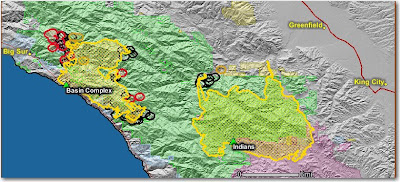
The crews made a lot of progress in the last 24 hours firing along the Arroyo Seco drainage. There was very little activity from the main fire. There is still the possibility that the Basin complex will burn into the Indians fire. A "zone" boundary line has been established between the two fires to clarify responsibilities. The Indians fire is 60,070 acres and 82% contained.
Basin Complex (Gallery and Basin fires)
The fire was very active on the northwest side. They have 16 dozers and 23 crews building line, with some of the lines being in the same places as on the 1977 Marble Cone and 1999 Kirk fires. Highway 1 is still closed to non-residents and evacuations are in place.
The map below shows heat, in red, orange, and black, detected by satellites last night, with the red areas being the most recently burned. The yellow lines are the perimeters uploaded by the incident management teams yesterday. Click on the map to see a larger version.


No comments:
Post a Comment