.

Sunday, November 16, 2008

Entourage: Smokejumper


On November 3 we wrote about the HBO Series "Entourage" and the fact that the main character in the series, Vince, is acting in a movie about wildland firefighting titled "Smokejumpers". Sunday night advanced the plot a little more and showed a scene that had Vince hanging in a tree after he missed the jump target area.


Without giving away too much about the plot, in the movie within the series, Vince, while hanging in a tree surrounded by fire, thinks he is going to die. In the photo above he is talking to someone on the radio asking them to tell his wife that he loves her.

It's a pretty good series... not a bad way to spend 30 minutes on a Sunday night.

California: update on southern California fires


The fires in the greater Los Angeles area are still burning actively with little containment. Overnight the winds have decreased and an inversion is trapping much of the smoke near the ground. However in some areas the fire is burning intensely and the smoke is breaking through the inversion layer.

WEATHER:
A wind advisory is in effect until 9:00 a.m. for northeast winds at 15-30 mph. There is a Red Flag warning effective until 4:00 p.m. today, for low humidities and high temperatures around 90

TRIANGLE FREEWAY COMPLEX FIRE (Freeway, Corona, Brea, and Yorba Linda area fires; the name changed again... now it's back to Freeway for this group of fires; geeze.... can't they make up their damn minds?)

UPDATE @ 3:30 p.m. Saturday

Here is a map produced by the LA Times. We can't vouch for it's accuracy and it's pretty crude, but it's one of the better ones we've seen, sadly.


View Larger Map

Here is an updated satellite map showing the latest thermal imagery. It shows that the fire has moved farther to the north on the northwest side, in the Chino Hills, Sleepy Hollow, Rowland Heights, and highway 57 areas. The red colors show the most recent heat. Click on the map to see a larger version.


------------------------------------------------

Thermal imagery map from a satellite Saturday night showing the fires in the Corona and Yorba Linda area. The red and orange areas show heat, with the red areas being the most recent. Click on the image to see a larger version of the map.

These two large fires are burning very close to each other and in fact may have burned together. They are now managed as one incident with the new name, "Triangle Freeway Complex". Over 100 structures have burned and the official size is 10,475 acres with 5% containment. In Anaheim, 12,600 are under evacuation orders, and 8,000-10,000 people in Yorba Linda have been evacuated.

Firefighters are conducting some large burnouts on the east side near 91 and 71. The fire is still active, especially in the Chino Hills and Yorba Linda areas. Early this morning some mobile homes burned in the Olinda Village in Carbon Canyon (Highway 142) on the northwest side of the fire.

A national Type 1 Incident Management Team will assume command of the fire tonight.

Residents who need information about evacuations can call 714-990-7732.


SAYRE FIRE (Sylmar, Newhall pass area)

Above is a thermal imagery map from a satellite Saturday night showing the Sayre fire in the Sylmar and Newhall Pass area. The red, orange, and black areas show heat, with the red areas being the most recently burned. The dark gray areas are the fires from mid-October, the Marek and Sesnon fires. Click on the image to see a larger version of the map.

As you can see from the map above, the Sayer fire has burned into last month's Sesnon fire. The official size of the fire is 9,500 acres and it is 30% contained.

Search and rescue teams with cadaver dogs will be combing through the Oak Ridge mobile home park where 500 mobile homes were lost. They will be looking for the remains of anyone who was not able to evacuate. Even though some people are not accounted for, hopefully they are safe and no remains will be found. An evacuation hotline has been set up, (800) 439-2909.

Wildfire news, November 16

Survivor of Tea Fire tells story

One person who left a comment on one of our posts about the Tea fire near Santa Barbara and Montecito writes a blog called "Blissful Ignorance". He has a house very close to the point of origin of the fire and wrote a very interesting article about his experiences. You should read it.

Wildfire-proof structure for remote area


Do you need a fire-proof cabin for your country retreat? Architect Casey Brown has designed a prefabricated, copper clad, structure that could be moved onto your vacation spot. As long as you live in Australia.


More information is HERE.


Washington: Airborne ignition device falls into Costco parking lot

From the Spokesman-Review in Spokane, Washington:
Spokane Valley firefighters want to know more about a nighttime UFO that dropped fireballs onto the Costco parking lot. Witnesses reported seeing two fireballs fall from the sky about 6:40 p.m. Nov. 6 at the Costco store at 5601 E. Sprague Ave., but investigators theorize that both came from the same airborne device.

Deputy Fire Marshal Bill Clifford said firefighters found a charred aluminum beverage can that had been cut open on one side to form a sort of "canoe." He said investigators speculate that the can was suspended horizontally, like a gondola, from a helium-filled balloon. Remnants of wadded paper towels or cloth were found stuck to the container.

The burning material and a pool of flammable liquid may have fallen in two pieces when fire caused the device to break apart, Clifford said.

Although it was raining when the fireballs fell, they could have injured someone or ignited a fire on the ground. A wildfire could have been sparked if the device had drifted over timberland in dry weather, Clifford said.

He said the charred can is being held as evidence, but any fingerprints probably were burned away.

Not surprisingly, it's illegal to launch such a flying firebomb. The likely charge would be reckless burning.
Hopefully firefighters will not be plagued with this as a new fire threat. It might remind you of the fire balloons launched by Japan against the U.S. during World War II.
Between November 1944 and April 1945, Japan launched over 9,000 fire balloons toward the American mainland. Carried by the recently-discovered Pacific jet stream, they were to sail over the Pacific Ocean and land in North America, where the Japanese hoped they would start forest fires and wreak devastation.

About three hundred were reported as reaching North America, but little damage was caused. Six people – five children and their mother Elise Mitchell – became the only deaths due to enemy action to occur on mainland America during World War II when one of the children tried to recover a balloon from a tree near Bly, Oregon and it exploded. Recently released R.C.M.P. and Canadian military reports indicate that fire balloons got as far inland as the rural area near Ituna Saskatchewan.
Was Wag Dodge an Einstein?

On the Mann Gulch fire in 1949 the smokejumper supervisor, Wag Dodge, lit an escape fire, stepped into it and survived, while most of the rest of his crew did not. Here is an excerpt from an interesting article in the Times in the UK about the human brain, and how there might be some genius in all of us. (Well.... not ALL of us. I could give you some exceptions that prove the rule... but don't get me started.)
At 6pm on August 5, 1949, a fireman named Wag Dodge and his crew found themselves cut off by a wildfire in Mann Gulch River Valley, Montana. A wall of flame was coming towards them at 30 mph. Dodge took a match out of his pocket and set fire to the grass immediately in front of him, stepped into the cleared space, covered his face and pressed himself into the ground so that he could breathe the thin layer of air beneath the smoke cloud. The fire rushed over him and he survived. The other 13 members of the crew hadn’t heard his order to do the same. They all died. [Two other crew members outran the fire and survived. B. Gabbert]

Like the story of Phineas Gage, the story of Wag Dodge has become an inspiration to neuroscientists. Why and how did he do what he did under such extreme conditions? “Wag Dodge — he’s a great one,” says Mark Jung Beeman, a professor of psychology at Northwestern University in Illinois. “It was particularly interesting in such a stressful situation. He was at the point where he basically gave up. He must have had some pretty awesome frontal lobes. Normally, high stress would limit creative, flexible or insight-type thinking, but not in this case.” Beeman’s phrase “at the point where he basically gave up” is crucial. Dodge had been struggling to find a way to escape the flames for some time. When, finally, the situation seemed to be hopeless, it is thought he had a moment of relaxation, of giving up, and that moment became his eureka moment.

Saturday, November 15, 2008

Multiple new fires in southern California

More fires have started in southern California and are being pushed by the Santa Ana winds. We will post maps of the fires as they are available.

"Freeway" fire near Corona and Yorba Linda

UPDATE @ 10:07 p.m. Saturday

The Freeway (or Corona or Yorba Linda) fire and the Landfill (or Brea) fire are still two separate fires and have not burned together yet. However, firefighters are confident that they will merge and it could happen as early as dawn on Sunday. If they merge at Carbon Canyon Road (Highway 142) it will be a real challenge for firefighers to protect the homes in that area if they have fires approaching from two different directions.


UPDATE @ 8:13 p.m. Saturday

Below is a screen capture from infrared imagery taken by a U.S. Forest Service research aircraft at 2:30 p.m. today. the lighter brown areas are burned, and the red is active fire. You can view the original imagery, and zoom and pan, by clicking HERE.

At that site you can then click on "Local Area Map for the Freeway Fire (Google Maps) with thermal overlay" which will overlay the thermal map over a Google street map. Be patient, it takes a while to load. Then you can toggle on or off the overlay by checking the box on the left side (because the overlay obscures the Google map).
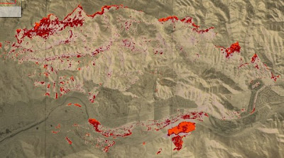

The last size reported on the fire late this afternoon at 9:00 p.m. was that it is 2,000 5,870 acres and 5% contained.

Structures lost on the Freeway fire, according to a spokesman on the fire:
  • 14 structures in Corona
  • 10 in Anaheim Hills
  • One 40-unit apartment complex in Anaheim Hills
  • 30 structures in Yorba Linda
More information is available about earlier report about the two firefighters that were injured, from Jon Dorsey of the CalFire Southern Operations Center.
At approximately 10:00 hrs, 1 Fire Captain, 1 Engineer and 2 Firefighters from Corona City Fire were injured while performing direct attack on the fire in the Green River Community. They were overcome by fire and all four suffered minor smoke inhalation injuries, with two receiving minor burns. Two were treated and released from Arrowhead Regional Medical Center, while the others were sent to Corona Regional Medical Center, where one remains at this time.

WEATHER:
The high wind warning has been canceled, but the red flag warning will continue until 4 p.m. Sunday. Temperatures will remain in the 80s until Wednesday, when it should be cooler.


UPDATE @ 4:42 p.m. Saturday

Below is a map showing thermal imagery from a satellite. The red areas are the two fires west of Corona in the Yorba Linda, Brea, and Anaheim areas. The western most one is the Brea or Dump fire. The eastern most one is the Freeway fire. It appears that this imagery is from late this afternoon. The Brea fire seems to have crossed the 57 freeway, and we already knew the Freeway fire was well established south of the 91.

Click on the map to see a larger version.


------------------------------------

UPDATE @ 2:27 p.m. Saturday

A 250-unit apartment complex south of the 91 freeway near Santa Ana Canyon Road and some single family dwellings in the same area are fully involved.

Here is an updated map that shows the approximate location of the Freeway fire west of Corona. Click on it to see a larger version.


-------------------------------------

UPDATE @ 1:45 p.m. Saturday

The fire crossed the 91 freeway in two places and 3,100 homes in the Anaheim Hills area (south of 91 and west of 241) are under an evacuation order.


---------------------------
11:40 a.m. Saturday

The DC-10 air tanker making a drop on the Freeway fire near Corona. It dropped continuously for 10 seconds, much longer than smaller air tankers. Oddly, there was a smaller twin-engine plane flying closely on the side of the DC-10, unlike lead planes which fly some distance ahead of air tankers.

Here is a map that shows the approximate location of the Freeway fire. Click on the map to see a larger version.
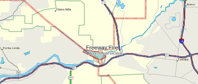


This fire, named Freeway, started late this morning and as of 11:40 a.m. PT has already burned 800-1,000 acres and has damaged or destroyed 12 homes. It is on the north side of the 91 freeway near Green River Road. It has burned into Yorba Linda where evacuations are in progress and some homes burned near Merryweather Circle.

An engine crew was burned over according to LA channel 7. Two firefighters have minor injuries and were treated at a hospital.

Fire in Brea ("Landfill" fire)

UPDATE @ 3:40 p.m. PT Saturday

The fire has burned quite a distance to the west and jumped the 57 freeway for a while but firefighters picked up that portion that crossed the freeway. A reporter from Fox 11 is at the fire edge on Wildcat Way just north of W. Lambert Road in Yorba Linda. HERE is a link to a map of that location.

Farther to the east at Hidden Hills Rd. and Greencrest Dr. many mega-mansions are burning to the ground. The situation is complicated by the fact that there is no water pressure at all in the water system. Firefighters are emptying the tanks in the engines, then leaving the area to get water, then returning again.

The director of the Yorba Linda Water District said that there are multiple pumping stations that pump water into some of the higher elevations that are burning now, and at least one of the pump stations burned. They are investigating the possibility of bringing in a pump to replace the one that burned. So... the fire suppression infrastructure works fine... until there is a fire. Just a idea: Make the pumping stations resistant to fire.

---------------------------------
11:40 a.m. Saturday

This is a new fire a mile or two or three west of the Freeway fire. It is smaller than the Freeway fire, but no additional information is available. It may have been a spot from the Freeway fire.

Update on Sayre fire near Sylmar, California

UPDATE @ 8:05 p.m. PT Saturday

Captured from LA Channel 4, below, is a partial list of the homes at the Oak Ridge Mobile Home Park that were saved. Of the 600 units, Channel 4 reported that 124 were saved. Again, our deepest sympathies for those who lost their homes.


The fire has burned 8,000 acres and is 20% contained. Approximately 500 mobile homes and 9 houses have burned. Five people have been arrested for looting. There are no confirmed fatalities, however the coroner has been dispatched to the mobile home park. Not everyone from the park has been accounted for.

-------------------------------

UPDATE @ 4:24 p.m. PT Saturday

The Los Angeles County Coroner has been called to the Oak Ridge mobile home park where hundreds of homes burned this morning. The coroner would not be summoned unless one or more bodies had been discovered. This is no doubt why they declared the park a crime scene. If a person is eventually determined to have started the fire, it is possible they could be charged with murder.

UPDATE @ 3:37 p.m. PT Saturday

Above is an updated map showing heat detected by satellite on the Sayer fire. The red and orange areas are the new fire, with the red areas being the most recently burned. It also shows the fires from last month, the Sesnon and Marek fires. It appears that the new fire, the Sayer fire, has burned into the Sesnon fire. Click on the map to see a larger version.

-------------------------------------

UPDATE @ 2:10 p.m. Saturday

According to the LA City FD the size of the Sayre fire is now estimated at 6,500 acres. The winds are 16 mph, with gusts up to 50 mph. The temperature is 90 and the relative humidity is 8%. The fire is still being pushed toward the Sesnon burn area of last month. More information about evacuations is HERE.


UPDATE at 12:10 p.m. Saturday

The Oak Ridge mobile home park where hundreds of homes burned has been recently declared a crime scene, and all media has been asked to leave the area. This may be a coincidence, but previously live video of the park this morning showed no visible smoke in the helicopter video. Then later, approximately three mobile homes were burning in an area where a small number of homes had been untouched by the fire. It makes one wonder if an arsonist ignited those additional homes.


------------------------

In our earlier posts here and here, we provided some initial details about the fire as well as a map of the approximate perimeter of the Sayre fire and an evacuation map of the fire. More details are now available.

  • The Oak Ridge Mobile Home Park has 600 spaces for homes. At least two-thirds Approximately 90% of the homes in that park burned between 3 and 5 a.m. this morning as 70 mph winds pushed the fire through the park.
  • Three of the five electrical transmission lines bringing power into the city are now shut down as power lines in the Newhall Pass area have been taken out of service as the fire burns through the area. Rolling blackouts are affecting many comunities. Live video as the fire burned under one of the lines showed electricity arcing from the lines down to the ground through the smoke .
  • The Santa Ana winds are expected to remain until about 2 to 4 p.m. today and temperatures will be around 90. Tomorrow the winds should not be a factor.
Our sympathies are with the hundreds of individuals and families who have lost their homes.

California: map of Sayre fire near Sylmar

(click on the map to see a larger version.)

In our earlier post we have some details about the Sayre fire, including an evacuation map and a thermal imagery map.

Based on the data from the thermal map, and information provided in the press conference, we put together a rough map showing the location of the Sayer fire in relation to the previous Sesnon and Marek fires of last month, which we mapped as they were burning in mid October. Again, the location of the Sayre fire on the map is only approximate.

We will update the map when more data is available.

California: Sayre fire near Sylmar, evacuation map

Photo by Pyromanic975

A new fire started late last night in Los Angeles in the Sylmar area. It is named the Sayer fire, and is burning in the same general area as the Sesnon fire of last month.

Here is a map showing the evacuation area, provided by Los Angeles Fire Department.


View Larger Map

In a press conference that concluded at 8:20 a.m. PT, the following information was provided by the Mayor of Los Angeles and fire officials.
  • The fire has crossed both the 5 and 210 freeways.
  • "Dozens" of structures have burned. An ICS-209 from about 7 a.m. said 65 structures had burned, but that number is likely to increase.
  • The fire has burned 2,600 acres and is spotting 1/4 mile ahead.
  • A major powerline that brings a large percentage of the electricity to the LA area is threatened. The fire is burning under and across it. If the powerline fails, it will have a huge affect on the urban area and rolling blackouts may be necessary. The mayor asked citizens to conserve power.
  • Four firefighters have been injured. Three of them are from LA City FD and one is from LA County FD. No other details were provided about the nature of the injuries.
  • Portions of the fire have burned into the Sesnon fire of last month.

Here is a map of the Sayer fire near Sylmar that was created from satellite imagery last night. It is at least several hours old and does not show that the fire has crossed the 5 freeway, which it has. The red area is the fire. It is moving toward the west or southwest.


Shortly after the press conference, a person from the LA Dept. of Water and Power was interviewed who said that of the 5 major powerlines coming into the city, two are down for repairs. He was not clear on why or when, but it seemed that they were already down when the fire started. This would complicate matters if a third one went down.

Friday, November 14, 2008

Infrared imagery of Montecito's Tea fire

A screen grab from the Infrared Imagery

Robert, in a comment on our earlier thread, "Map of Tea Fire From Television", said:
I just posted this morning's thermal IR imagery- http://www.fireimaging.com/homepage.html
Thanks Robert. For those not familiar with infrared imagery, it is not exactly a map, but is a plot of heat detected this morning by sensors on an aircraft. Trained infrared interpreters can take this imagery and draw the perimeter of the fire on a map.

The resolution of the "map" is not great but you can almost see where houses are in the Santa Barbara and Montecito areas.

Very cool. Thanks Robert.