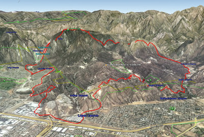
The incident management team posted a perimeter map of the Marek fire. It shows the perimeter as of Monday night. In this view, we are looking toward the northeast. Click on it to see a larger version.

The Sesnon fire has now grown to 13,285 acres. Lighter winds during the day on Tuesday enabled firefighters to make some headway constructing firelines on the east flank. No containment figure has been announced.
The Sesnon fire is still listed at 4,824 acres and 70% containment.
Update @ 4:20 p.m. Tuesday
After realizing that LA County FD and LA City FD were not going to produce any usable maps of the fires, using our sources within the fire community, we produced a rough map of our own based on where the fire was at about 9 p.m. PT Monday night . The perimeters are only approximate, but they are a little better than what has been available to the public. Click on the map to see a much larger version.

7:44 a.m. PT, Tuesday

MAPS
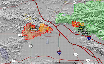
Here is a map of the Sesnon and Marek fires. It shows heat, in red, orange, and black, detected by satellites last night, with the red areas being the most recently burned. Click on the map to see a larger version.

The map below of the Sesnon fire is provided by LA County Fire Department and it shows only an approximate location of the fire. It should update automatically with data provided by the LACFD if you refresh your browser.
View Larger Map
The map below of the Marek fire is provided by LA County Fire Department and it shows only an approximate location of the fire. It should update automatically with data provided by the LACFD if you refresh your browser.
View Larger Map
It is ridiculous that two of the largest fire departments in the world (Los Angeles City FD and Los Angeles County FD), with fires going that are affecting millions of people and have killed two, are capable of only producing these two pitiful, inaccurate, Google maps. The satellite map at the top of the post is far more helpful. These fires have been burning for 2 days. There is no excuse for not providing better information to thier customers.
EVACUATION, SHELTERS, AND TRAFFIC
Local residents can get information about fire-related traffic, evacuations, and shelters by calling a recording provided by the LA Fire Department at 800-439-2909.
SESNON FIRE FACTS
The fire has burned 9,872 acres, is
MAREK FIRE FACTS
This fire has burned 4,824 acres and is 70% contained, with 1,355 firefighters assigned. 39 structures have burned, with 38 of them being mobile homes.
WEATHER
Current weather in the fire area:
Newhall Pass @ 6:35 a.m.: winds east @ 6 with gusts to 31, RH 18%.
Little Tujunga @ 6:54 a.m.: winds NE @ 3 with gusts to 33, RH 12%
A Red Flag warning is valid until 10 p.m. Wednesday for strong Santa Ana winds and low humidities.
A wind warning is in effect until noon for LA, Ventura, Orange Counties, Mountains, and Inland Empire for NE winds from 30-45 mph, gusting to 70.
A wind advisory is in effect until 3 p.m. for the rest of southern California.
Photo courtesy of LA Times


No comments:
Post a Comment