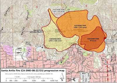
As of this morning the fire is 538 acres and is 57% contained. Most of the contained fireline is in the eastern areas near the Sierra Madre residences. Southern California Interagency Incident Management Team 3 assumed command of the fire at 6:00 p.m. on Sunday. Approximately 150 homes and 400 people remain evacuated.
Live video from a news helicopter this morning showed no visible smoke, but this was from several thousand feet above the fire.
================================
Monday, April 28
Today the Santa Anita fire near Sierra Madre, California, made some upslope runs and also spread to the southwest. As of 8:00 PM today (Monday) it was 538 acres and 21% contained.
The evacuation boundary now extends west to Michillinda Avenue in Sierra Madre. The southern boundary of the current evacuation zone from west to east, is Fairview Avenue to Grove, north along Grove to Carter Avenue, east along Carter Avenue to Baldwin Avenue.
As of 8:00 p.m. Monday April 28, evacuations will be lifted for homes east of Baldwin Avenue.
Click on the map to see a larger version.
 Map of the Santa Anita fire near Sierra Madre, produced by the incident at 3:00 PM local time, April 28, 2008.


No comments:
Post a Comment