.

Thursday, July 31, 2008

Crews make progress on Yellowstone fire

From Yellowstone National Park:
Lighter winds and additional firefighters resulted in a day of significant progress on the LeHardy Fire in Yellowstone National Park.

Sparks from a downed powerline are the suspected cause of the fire, which started Wednesday afternoon near LeHardy Rapids along the park’s Grand Loop Road three miles north of Fishing Bridge.

The fire started in a powerline corridor which runs west of the road.
Gusty southwest winds cause the fire to move east, first jumping the road and then jumping the Yellowstone River. That prompted temporary closure of the road between Fishing Bridge Junction and Mud Volcano, which is south of Canyon Junction. The fire also cut electrical service to the Fishing Bridge and Lake area, which are currently running on a large generator.

Thursday’s firefighting efforts were focused on the west side of the Yellowstone River. Morning retardant drops from large air tankers and afternoon water drops from helicopters aided hand crews who spent the day constructing a control line along the fire’s west flank. The goal is to contain the fire on the west bank of the Yellowstone River in order to
reopen the road to visitor travel and restore commercial power. About 140
people are assigned to the LeHardy Fire, up from 67 on Wednesday night.

Mapping conducted after a late Thursday afternoon reconnaissance flight has resulted in a revised, lower fire size estimate of 505 acres.

Telegraph fire update, July 31

The Telegraph fire has now burned 33,705 acres and is 40% contained. The active portions of the continue to be on the north and east flanks of the fire near Jenkins Hill in the Merced River drainage. This area is a high priority for the deployment of firefighting resources. Crews have made excellent progress in diminishing the threat of fire to structures in the Midpines and Mariposa areas. Some 200 residences were allowed to return to their homes yesterday. The fire is still about 7-8 miles west of the El Portal entrance to Yosemite National Park.

The fire has two incident management teams assigned, CalFire teams #6 and #8.

The Martin Mars water-scooping air tanker, on contract from a Canadian company, took off from Lake Shasta at 1:00 p.m. on Wednesday enroute to the Telegraph fire to assist with the suppression efforts. It was expected to work the fire for about 3.5 hours, dropping 7,200 gallons at a time, before returning by 7:00 p.m. to Lake Shasta in northern California, near Redding.

Contrary to a report elsewhere, there is only one Martin Mars air tanker working in the United States. The company has a second one, but it has been out of service at their base in Port Alberni, BC, Canada for an extended period of time. The Martin Mars works with their own "bird dog", a small aircraft called a lead plane in the U.S., that flys the drop route in advance of the air tanker. Their bird dog is unusual, in that it has floats rather than wheels, and can land on the same lakes as the much larger Martin Mars.

File photo of the Martin Mars scooping water from Lake Shasta.

The map below shows that the only major heat sources detected by satellites was on the northeast and east sides. It shows heat, in orange and black, detected by satellites last night, with the orange areas being the most recently burned. The yellow line is the latest perimeter uploaded by the incident management teams. Click on the map to see a larger version.


Telegraph fire T-shirts and other items are available from our sponsor HERE.


Cascade fire update, Red Lodge, MT

The Cascade fire, pushed by strong winds, grew substantially towards the east in the last 24 hours, from 5,936 to 9,411 acres. Late on Wednesday it was about a mile from the Red Lodge Mountain ski area and three miles west of Red Lodge. The Billings Gazette has an interesting article about the fire.

There is another article about Tom Moore, who lost a cabin in the Cascade fire and two years ago lost his house in a fire in Idaho.

The map was created at 5:00 p.m. on Wednesday.

Andrew Palmer's autopsy completed. Dan Packer flown home.

More details are now available concerning the death of Andrew Palmer, a National Park Service firefighter, who was killed Friday when he was struck by a falling tree while fighting a fire on the Shasta-Trinity National Forest in northern California.

An autopsy revealed that he died of blood loss from a blunt force trauma to his upper left leg. From the Redding Searchlight:
Fire officials have said that Palmer suffered multiple injuries after being hit by a tree during an operation to secure a fire line. It was his first day on the fire line.

Although specifics of the accident have not been publicly released, Palmer’s family told their hometown newspaper that they were informed that their son was in a safety zone when a tree was cut downhill from his position.

It slid downhill and spring-boarded into another tree, which caused a third tree to flip back uphill. That flying tree struck Palmer, reportedly breaking his left leg and right shoulder.

Palmer died while being flown by a U.S. Coast Guard helicopter to Mercy Medical Center in Redding.

Hired in June as a firefighter with Olympic National Park based in Port Angeles, Palmer was assigned to the Iron Complex of fires in the Shasta-Trinity National Forest a few days before the accident.

A memorial service is planned for him Monday at Fort Worden State Park in Port Townsend.
Daniel Packer

Daniel Bruce Packer, 49, of Lake Tapps, Wash., died Saturday while scouting the Panther Fire near Happy Camp in Siskiyou County. He had sought cover from a fiery blow-over under his personal emergency fire shelter, fire officials have said. An autopsy performed Tuesday showed that Packer died as a result of thermal burns and smoke inhalation.

Packer’s body was flown home Wednesday aboard a U.S. Forest Service DC-3 from Siskiyou County Airport near Montague to Tacoma Narrows Airport.

A funeral procession to the airport, which passed numerous mourners paying their respects along the route, included a U.S. Forest Service honor guard, representatives of the Klamath National Forest, California Department of Forestry and Fire Protection, and Yreka Volunteer Fire Department. His body was accompanied by his wife and representatives from East Pierce Fire and Rescue of Bonney Lake, Wash.

A memorial service is planned for him next Thursday at the Christian Faith Center in Federal Way, Wash., while a sunrise memorial service to honor him is set for 6 a.m. Friday at the Ukonom Complex Incident Command Post in Orleans in southwest Siskiyou County. Another memorial service is at 7 p.m. Friday at River Park in Happy Camp.

Cascade, Gunbarrel, and LeHardy fire map

Here is the latest map showing heat detected by satellites last night for the three fires in northwest Wyoming, Yellowstone NP, and in the southern Montana Red Lodge area.

Wednesday, July 30, 2008

Map of Smoke

It has been a couple of weeks since we put up a smoke map.....

Fire in Yellowstone NP

UPDATE @ noon, July 31

An unofficial source tells me the fire is now 900 acres, but that is not confirmed.

=====================

UPDATE @ 8:10 a.m. July 31

Yellowstone National Park is saying the size of the fire was 600 acres as of dusk Wednesday night. More information from the park:
Gusty southwest winds pushed the fire east across a section of the road about three miles north of Fishing Bridge near LeHardy Rapids, and then jumped across the Yellowstone River. Winds aligned with a creek drainage on the east side of the river prompted steady, rapid fire growth through the afternoon and into an evening.

Yellowstone National Park firefighters, West Yellowstone smokejumpers, two Type 1 air tankers from Billings, two helicopters, and fire engines from several surrounding areas are already assigned to the fire. Additional firefighting resources including two Type I hand crews are on order and are expected to arrive overnight and into the morning.

The weather forecast for Thursday calls for temperatures in the 70s, with humidity between 17 and 23 percent and afternoon winds from the southwest at 10 to 15 miles an hour with gusts to 25 miles and hour.

The LeHardy fire near the Yellowstone River at 4:10 p.m. July 30. National Park Service Photo.

===========================
7:48 p.m. July 30

Yellowstone National Park has a fire burning about 3 miles north of Fishing Bridge. The LeHardy fire jumped the Grand Loop Road and the Yellowstone River shortly after it started and as of 8:00 p.m. MT tonight is 650 to 900 acres. This makes four fires now in that part of the country.

Here is an excerpt from a Yellowstone News Release, issued at 4:45 p.m. MT today. Note that the fire has grown substantially from the 5-10 acres at 4:00 p.m.

A fire caused by a downed powerline and fanned by gusty afternoon winds, has led to the temporary closure of a section of the Grand Loop Road north of Fishing Bridge in Yellowstone National Park.

The fire started in a powerline corridor which runs west of and parallel to the road near LeHardy Rapids, which is along the Yellowstone River about 3 miles north of Fishing Bridge Junction.

Winds have pushed the fire to the east, where it has crossed the Grand Loop Road and subsequently jumped across the Yellowstone River.

As of 4:00 pm, the LeHardy Fire is estimated at 5 to 10 acres. Yellowstone National Park firefighters are on scene with two fire engines and a water tender. Additional firefighting resources have been ordered including smokejumpers, additional engines, and helicopters.

A few miles out ahead of the fire to the east are the the East (18,050 a.) and Grizzly (4,460 a.) fires of 2003, and to the southeast, the the Columbine 1 fire (18,500 a.) of last year. Since it was caused by humans, it most likely will be suppressed.

Click on the photo (centered over Wyoming) below to see a larger version.


Wildfire news, July 30

Safety stand down

The National MAC Group (Multiagency Coordinating Group) has issued a recommendation for a Safety Stand Down on August 1. Here is an excerpt from the memo:
Two fatalities occurred over the weekend in two separate Northern California fires. A recent spike in accident/injury trends has also created concerns for firefighter safety. To date we have exceeded the number of deaths in wildland fire operations for 2008 that we experienced during all of 2007. In an effort to draw attention to wildland firefighter safety, NMAC is requesting that all geographic areas take one hour during the operational period of August 1st to emphasize safety practices.

NMAC issues Long-Term Strategy

The National MAC group (sometimes called "Big Mac") also distributed a "2008 National Multi-Agency Coordinating Group Long-Term Implementation Strategy".
The National Multi-Agency Coordinating Group Long Term Implementation Strategy was created in July 2008 and tiers off the NMAC Preparedness Strategy for 2008. The strategy is situationally driven and will be updated as the season progresses to reflect the current situation, and as warranted by wildland fire activity and events tied to the National Response Framework.
Most of the document covers the current situation and the average conditions for July and August. One thing I found interesting is this table that shows what I would call the probability of season-ending events by geographic area, the date at which weather and precipitation events cause the fire season to end.


But pages 7-9 contain recommendations, some rather vague and general, others useful, about how to manage resources during a time when they are scarce and fires are many.

National Guard protects Big Tree


The California National Guard issued a news release describing how a 20-person National Guard crew protected a 240-foot, 700-year old Ponderosa pine that is on the American Forests' National Register of Big Trees from burning during one of the fires on the Shasta-Trinity National Forest in northern California.
"It was a lot of hard work and heart that went into keeping this incredible tree safe," said Spc. Diana Diaz. "This majestic tree has witnessed a lot of history and stands as a symbol for survival. There have been wildfires through these forests before ... and this tree still stands. We're working hard to make sure that she makes it through this fire too."

That task wasn't easy. With low-hanging branches, the tree was immediately threatened by sparks and embers from nearby fires that could easily ignite the tree if the wind shifted just right.

The team of Guardsmen spent hours trimming these low-hanging threats and also cleared a wide area around the tree that would eliminate any fuel source on the ground.

Two Guard members spent the entire day cutting down neighboring trees, and the rest of the team stacked piles of wood that would burn a safe distance from the tree. They also set up a water sprinkler system that would keep the cleared area moist.

Gunbarrel fire, Wyoming

UPDATE @ 5:17 p.m. MT July 30

The fire has doubled in size again, and is now 4,100 acres according to InciWeb. Near-real-time satellite photos show that it is putting up a great deal of smoke.
"Growth expected to the east/northeast. Strong west/southwest winds could push the fire over the ridgeline below Monument Peak into Moss or Clearwater drainages towards the east."

=======================

10:57 a.m. MT July 30

This "fire use" fire 40 miles west of Cody and 8 miles east of Yellowstone National Park doubled in size over the last 24 hours. The fire is 2,103 acres and is not being suppressed. It will be herded around within a designated "maximum management area". Fire crews are setting up structure protection for some buildings that are on the North Fork of the Shoshone River about two miles from the fire.

Gunbarrel fire, July 28 @ 3:32 p.m. MT; photo by U.S. Forest Service


Thanks to Chuck and FireNet for the tips about the Big Mac missives.

Smaller budgets = larger fires?

An article on the Red, Green, and Blue website wonders if decreasing budgets for fire prevention and the land management agencies results in larger wildfires. Here is an excerpt:
Year after year, Bush has cut funding from the USFS, yet within this budget, more money is allocated for fire management and less for fire prevention. In February, 2008, Bush proposed decreasing fire preparedness monies by 11 percent. Although the budget calls for a $150 million increase for extinguishing blazes, prevention funding is slashed by $77 million, including a $13 million reduction in small fuels removal. Similar cuts were proposed in 2007. Casey Judd, business manager for the Federal Wildland Fire Service Association, a firefighter employee group explains, “The administration still has it backward.

Preparedness should be the focus, not suppression.” Norm Dicks, D-Wash., adds, “Common sense would be that if you put more money into fuel reduction, it’s going to have an effect on having less severe fires.” The White House response was that money could be shifted between the agency’s firefighting and fire suppression accounts, as needed. This is exactly what concerns USFS employees with the current California wildfires.
The article has a quote from Al Gore:
Today, unprecedented fires are burning in California and elsewhere in the American west.

Higher temperatures lead to drier vegetation that makes kindling for mega-fires of the kind that have been raging in Canada, Greece, Russia, China, South America, Australia, and Africa. Scientists in the Department of Geophysics and Planetary Science at Tel Aviv University tell us that for every one degree increase in temperature, lightning strikes will go up another 10 percent. And it is lightning, after all, that is principally responsible for igniting the conflagration in California today.

Memorial services for two fallen firefighters scheduled

The memorial service for National Park Service firefighter Andy Palmer, who was killed while fighting the Iron fire last week on the Shasta-Trinity National Forest in California, will be held on Monday, August 4. The service will be held from 10 a.m. to 1 p.m. on Monday, August 4th, at McCurdy Pavilion in Fort Worden State Park in Port Townsend, Washington. In lieu of flowers, an Andy Palmer Memorial Scholarship fund has been established through the Port Townsend High School Scholarship Foundation. Donations may be sent to the Foundation at 538 Calhoun Street, Port Townsend, WA 98368.

An obituary for Palmer is HERE.

The memorial service for Chief Dan Packer will be held at 2 p.m. Aug. 7 at Christian Faith Center, located at 33645 – 20th Avenue South in Federal Way, Washington. The public is invited to attend. Packer was entrapped by flames on the Panther fire on July 26 on the Klamath National Forest in northern California. Packer was the chief of the East Pierce Fire & Rescue in Washington. In lieu of flowers, monetary contributions can be made at any Washington Mutual Bank under the Fire Chief Dan Packer Memorial Fund. Checks may also be mailed to: East Pierce Professional Firefighters at P.O. Box 7500, Bonney Lake, WA 98391.

Cascade fire, Red Lodge, Montana

The Cascade fire caused the evacuation of 90 homes in the Grizzly Peak subdivision and firefighters said if the fire moves into the area, it the houses will not be defended, because of severe safety issues for firefighters. Six structures have been destroyed by the fire which is 5,936 acres and is 5% contained. The snow making machines at the Red Lodge Mountain Ski Area, 1.5 miles from the fire, are being used to spray water on the slopes and around structures

An update from the incident management team at 9:00 p.m. yesterday included this information:
Fire fighting efforts are focused on the north and east ends of the fire today. Hand crews on the west end of the drainage are working onto the north and south sides constructing line and flanking the fire along the ridge tops. Heavy timber, steep, rocky terrain and limited access from roads and water sources remain challenges to fire fighting efforts. An additional 12 loads of retardant (28,000 gallons) from heavy airtankers and 30,000 gallons of water from helicopters were applied to the northeast end of the fire along the ridge near Red Lodge Mountain Resort to keep the fire from spreading further east.
A local resident and his family were hiking in the area and had their route cut off by the fire. With the help of some Forest Service trail workers, Don Larsen and his three children hiked 10 miles to safety, but their car is still marooned at the trail head.

The updated satellite map from last night shows the fire being most recently active on the west side. The map shows heat, in red, orange, and black, detected by satellites, with the red areas being the most recently burned. The yellow lines are the latest perimeters uploaded by the incident management teams. Click on the map to see a larger version.

Telegraph fire, July 30

Telegraph fire

8:41 a.m. PT July 30

CalFire provided an update this morning. They are saying the fire is 32,063 acres and is 20% contained. The fire has destroyed 21 residences and 32 outbuildings. Structures threatened include 4,000 residences in the communities of Midpines, Briceburg, Mariposa, Greenley Hill, Coulterville, Bear Valley, and Mt. Bullion Camp. Evacuation information can be found HERE and highway conditions can be found HERE.

The resources on the fire:
  • 3,790 Personnel
  • 443 Fire Engines
  • 74 Hand Crews
  • 65 Dozers
  • 38 Watertenders
  • 15 Helicopters
  • 12 Airtankers

6:34 a.m. PT July 30

The heat detected by the satellites last night shows that the fire was most active on the north side where it expanded quite a bit beyond the last perimeter uploaded by the incident management team. Click on the updated map below to see a larger version.

A 10-mile stretch of Highway 140 was closed for much of yesterday. The fire is still 7-8 miles west of the El Portal entrance to Yosemite National Park.

The Fresno Bee has an article about evacuating animals from the fire zone. The Sacramento Bee (what's with the BEE newspapers?) has a touching story about a woman whose house burned, but she continues her job as a care worker. The San Francisco Chronicle's story about the fire features local residents, one is "sheltering in place" refusing to evacuate, and others have left their homes.

CalFire has not provided any updated information since noon yesterday. We will update this post throughout the day today as more is available.


We want to welcome a new sponsor, CafePress, who is offering T-shirts and other items to commemorate the Telegraph fire.

Tuesday, July 29, 2008

New Smokey Bear ad cancelled

On June 3 Wildfire Today told you about the new Smokey Bear public service announcements. An off road vehicle group complained that one of the ads seemed to imply that the legal use of an ATV could cause forest fires. Don Amador, the Western representative of the BlueRibbon Coalition in Idaho, said the ad:
"...incorrectly conveyed to the ATV rider that the best way for them to prevent wildfires was to stay at home. Instead, the ad should have encouraged the use of Forest Service-approved spark arresters and limiting travel to approved routes and areas."
The Forest Service has requested that TV stations discontinue using the ad.

Wildfire news, July 29

UPDATE @ 6:00 p.m. MT, July 29

Cascade fire (west of Red Lodge Montana)

Five structures have been lost in the Camp Senia area, and one burned at the MSU research camp. The acreage has not been updated since the 5,800 figure was given yesterday. Here is more information from a 5 p.m. update from the incident management team:
Fire fighting efforts are focused on the north and east ends of the fire today. Hand crews on the west end of the drainage are working onto the north and south sides constructing line and flanking the fire along the ridge tops. Heavy timber, steep, rocky terrain and limited access from roads and water sources remain challenges to fire fighting efforts.

A RED FLAG WARNING has been issued for the fire area today. The change in the weather is anticipated to bring a cold front passing through the area with increased potential for higher winds and thunderstorms in the afternoon and evening Changing weather conditions bring a watch out for increased fire activity and the potential for rapid fire spread which would likely trigger additional evacuations toward Red Lodge. Pay attention to changing weather conditions and be prepared to leave if an evacuation is ordered.

An updated map from the Incident Management Team is now available. Click on the map below to see a larger version.

See below for more information about the Cascade fire.


Telegraph fire

The fire has been very active on the northeast and east sides today, moving closer to Yosemite National Park, which is now about 6-7 miles east of the fire. See below for a map and more information about the Telegraph fire.

Gunbarrel fire

While InciWeb says the fire is 625 acres, the Associated Press reports the Gunbarrel fire has burned 1,200 acres. Judging by the thermal imagery from the satellites, it is far more than 625 acres. See below for more information.

====================================

8:16 a.m. MT, July 29

Gunbarrel fire, Wyoming


The Gunbarrel fire, 38 miles west of Cody, Wyoming, grew from 232 acres to 800 in the last 24 hours. But it appears to be larger than that, judging from last night's satellite images. The fire is currently designated as a "fire use" fire, meaning it will not be suppressed, just monitored and herded around as long as it remains within a designated area. On InciWeb yesterday, the fire is described this way:
The fire is burning in heavy timber with lots of bug-killed trees. The hot, dry weather will continue, resulting in active fire behavior.
On the National Situation Report the Incident Management Team described it late yesterday as:
Backing fire with single and group tree torching and short-range spotting.
A "backing fire" that tripled in size. Hmmmm.

Gunbarrel fire, July 28, 2008

It is July 29, and there are still at least five to seven weeks of fire season left in that area. However, the fire is in a huge imperfect bowl (see satellite photo below), surrounded in some areas by slopes with little or no vegetation which will serve to slow or limit the spread of the fire. We will be interested to see if 1) the fire remains relatively small and within the bowl, and 2) if the designation is changed from a "fire use" fire to a full suppression fire. This fire will be fascinating to watch and Bill Hahnenberg's Fire Use Team will have their work cut out for them as they put together their Wildland Fire Implementation Plan.

The yellow, red, and orange dots on the map indicate the approximate extent of the fire, as detected by heat-sensing satellites. Click on the maps to see larger versions.


The map below shows both the Cascade fire west of Red Lodge, MT, and the Gunbarrel fire west of Cody, WY. The red dots are symbols for heat that was detected by satellites within the last 12 hours. But we have learned that the dots, which are supposed to represent the approximate extent of the fire, are not as accurate in their location as the cross-hatched polygons. So interpret the maps with a grain of salt. The green areas are national forests, and the purple area is Yellowstone National Park.

The Cascade fire

The fire is 7-8 miles west of Red Lodge, Montana, and will be influenced by a Red Flag Warning today. Thunderstorms along with strong wind gusts up to 40 mph and lightning are predicted. The fire was last reported on Monday as being 5,800 acres and 0% contained. A Type 1 Incident Management Team with Incident Commander Bennett began arriving yesterday.

A ski area is about 2 miles from the fire. From the Billings Gazette:
Red Lodge Mountain Resort is putting its snowmaking equipment to use in hopes of protecting the ski hill from the Cascade fire, burning less than two miles away in the West Fork of Rock Creek.

Ten guns, capable of spraying 85 gallons of water a minute are soaking the ground around chair lift terminals, motor rooms and the resort’s two lodges. The guns draw water from ponds near the top of the mountain.

“It looks like we’re making snow, but we’re just blowing water,” said Rob Ringer, general manager of the Red Lodge Mountain Resort.
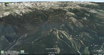
The map below shows the Cascade fire looking toward the west. The ski area is in the foreground, and the yellow and red dots indicate the approximate extent of the fire. The road that goes up the main canyon through the fire is West Fork Road (NF 71).


Telegraph fire

The fire is just north of Mariposa, California and 7 to 8 miles west of the El Portal entrance to Yosemite National Park. As of Monday night the fire had crossed the Merced River and had consumed 29,600 acres. Containment was at 10%. Structures destroyed include 25 residences and 27 outbuildings. Over 3,400 firefighters and 400 engines are assigned.

Currently threatened are the communities of Mariposa, Midpines, Greeley Hill, Coulterville, El Portal, Morman Bar, Boot Jack, Mt Bullion Conservation Camp, the Mariposa Utility District water supply, 70 kv transmission line supporting Yosemite Valley, as well as Yosemite National Park and numerous communication/repeater towers. More information, including evacuation instructions, can be found at the CalFire web site.

From the CalFire "Fact Sheet" issued at 7:00 a.m. PT today:
The fire is making major runs in all directions thru thick stands of Manzanita, Chamise, and Oak. Extreme fire behavior was observed with flames lengths of up to 100 feet reported. Similar burning conditions are expected in the next 24 hours. The fire is moving into the Sierra and Stanislaus Forest, affecting 70kv transmission line providing power to Yosemite Valley. A firing operation in the Dogtown area may generate visible smoke over the next 24 hours.

HERE is a link to a CalFire map, produced very early Tuesday morning.

Rescued bear improving

On July 17 we covered the story of the injured bear that was rescued in a fire in northern California by firefighter Adam Deem. Since then the bear, dubbed "Little Smokey", has been undergoing treatment for his burns at the nonprofit Lake Tahoe Wildlife Care facility. The Redding Searchlight has the details HERE.

More conflicting headlines

Last week we pointed out some conflicting headlines. Here are some others, just found on Google News.

Fire By Yosemite Not Slowing Park Visitors
News10.net, CA - 1 hour ago
MARIPOSA, CA (AP) -- Even with a major entrance into Yosemite National Park closed, a ranger says people are hiking, the campgrounds are full and everyone is taking the smoke from a nearby wildfire "in stride." (Slide show). The Telegraph Fire near a ...

Yosemite fire causes visitors to cut stay short
Los Angeles Daily News, CA - 1 hour ago
Some visitors packed their bags and left campgrounds and other areas near Yosemite National Park on Monday as a wildfire burned out of control outside the famed wilderness area.

Monday, July 28, 2008

LA Times' series of articles on wildfires

The Los Angeles Times on Sunday started a series of 5 articles on wildland fire. Here is how the paper describes the articles, written by two reporters:
The pair have worked for more than a year, traveling around the country and as far as Australia, to report on these stories, which include multiple sidebars, graphics, video and fiery photos as part of the package.

"A century after the government declared war on wildfire, fire is gaining the upper hand. From the canyons of California to the forests of the Rocky Mountains and the grasslands of Texas, fires are growing bigger, fiercer and costlier to put out. And there is no end in sight."
If the length of Sunday's article is any indication this is a massive undertaking. And some of the photos are amazing. The first two articles are available; links are below.


A century after the government declared war on wildfire, fire is gaining the upper hand. Wildland blazes are growing bigger, fiercer and harder to put out. Firefighting costs are rising, too, and much of the money is going to private contractors. »


Fire commanders are often pressured to order firefighting planes and helicopters into action even when they won't do any good. The reason: Aerial drops of water and retardant make good television. They're a visible way for political leaders to show they're acting decisively to quell a fire. Firefighters call them "CNN drops."

By Bettina Boxall
More and more Americans are moving into fire-prone canyons and woodlands. The settings are picturesque but road networks are often inadequate. In a wildfire, everyone may not be able to get out safely.

By Bettina Boxall
From Frederic Remington paintings to Gene Autry songs and John Wayne movies, the cultural imagery of the West is steeped in sagebrush. Now, a devastating cycle of fire, fueled by non-native plants, is wiping sagebrush from vast stretches of the Great Basin.

By Julie Cart
Wildfire is a pervasive danger in Australia, just as in much of the Western U.S. But Australians cope with the threat very differently than Americans do. Rather than rely on professional firefighters to protect their lives and property, many Australians do it themselves.

Two fires, east and northeast of Yellowstone

Two fires are burning east and northeast of Yellowstone National Park.

The Cascade fire on the Custer National Forest 8-10 miles west of Red Lodge, Montana has consumed 5,100 acres and has burned five summer homes in the Camp Senia area. The Grizzly Peaks subdivision about three miles west of Red Lodge was evacuated Sunday as a precaution. There are an estimated 40 to 50 homes in the subdivision. Another 40 to 50 homes west of Red Lodge were also evacuated. Bennett's Type 1 Incident Management Team is assigned. The Missoulian has an article about the fire.

The 232-acre Gunbarrel fire, 40 miles west of Cody, Wyoming, is a "fire use" fire on the Shoshone National Forest. Hannenberg's Fire Use team has been ordered.

On the map below, the purple area is Yellowstone National Park, and the east-west black line is the WY-MT border. Click on it to see a larger version.

More information, firefighter death on Panther fire

We offer our sympathies to the family and co-workers of Chief Daniel Packer of the East Pierce County Fire and Rescue of Lake Tapps, Washington.

From Redding.com:
Firefighter’s body recovered, identified

By Record Searchlight staff
Originally published 08:13 a.m., July 28, 2008
Updated 08:13 a.m., July 28, 2008

The remains of a firefighter who died battling the Panther Fire have been retrieved and the Washington man’s identity has been confirmed, a Siskiyou County Sheriff’s dispatcher said this morning.

Daniel Bruce Packer, 49, of Lake Tapps, Wash., died while working on the blaze about 15 miles south of Happy Camp in southwestern Siskiyou County. The U.S. Forest Service reported the death Saturday, but the fire’s intensity and limited visibility kept crews from recovering or positively identifying Packer’s body until Sunday, sheriff’s dispatcher Dennis Moser said today.

A Forest Service ground team lead by a Siskiyou County sheriff’s deputy was able to reach the site by 6 p.m. Sunday, sheriff’s spokeswoman Susan Gravenkamp said that evening. A ground team was expected to carry Packer’s body from the fire area to the nearest road, a job estimated to take three hours, she said Sunday.

An autopsy will be scheduled for early this week.

From King5:
Flags at fire stations throughout the state are flying at half staff after a prominent fire chief from Washington died Saturday while scouting a Northern California blaze, fire officials have confirmed.

Siskiyou County Sheriff's Department spokeswoman Susan Gravenkamp said Sunday that investigators believed 49-year-old Daniel Packer of Lake Tapps, Wash., chief of East Pierce County Fire and Rescue in a 142-square-mile area with a population of 72,000 east of Tacoma, died over the weekend.

The identity was confirmed by Mike Brown, executive director of the Washington State Fire Chiefs, of which Packer was the immediate past president, and by Spokane, Wash., Assistant Fire Chief Brian Schaeffer, a colleague on the board of the state group.

Packer was working as a division supervisor on the 250-acre Panther Fire in the Siskiyou Mountains, part of the Siskiyou Complex of fires covering 54,000 acres, more than 8.4 square miles, according to a news release and death notice issued by Schaeffer.

"He was overrun by the fire when the wind shifted unexpectedly," Schaeffer wrote.
Related Content

Another firefighter managed to flee on foot, Davida Carnahan, a spokeswoman for the Klamath National Forest, told the Seattle Post-Intelligencer. It was unclear whether the surviving firefighter was injured, but he declined medical attention, she said.

"We've pulled the crews off of that fire because of the impact it has had mentally and emotionally when they lose one of their own," Carnahan said. "We have not been able to retrieve the remains, because the fire is too unstable to get in there."

Klamath National Forest spokesman Duane Lyons said a U.S. Forest Service team would arrive Monday to investigate the cause of his death.

In his work with the chiefs association, Packer was especially involved in state emergency mobilization and incident management team planning, Schaeffer added.

"He was a veteran wildland firefighter," McCallion said. "Dan took that experience and helped develop our own wildland firefighting team."

Packer is survived by his wife, four daughters and two grandchildren.
HERE is a link to a video report from King5.

UPDATE @ 8:30 p.m. PT July 28:

HERE are a few more details, including the fact that he deployed his fire shelter.

UPDATE @ 7:55 p.m. PT July 29

HERE is another story, including information that a crew that had been in the same area the day before and had a close call, had decided they would not return the following day because they deemed it unsafe.

Telegraph fire update

UPDATE @ 5:40 p.m., PT July 28

HERE is a link to a map that is on the CalFire site. The colors on the map are confusing, in that they don't match the legend. A CalFire update at 3:15 p.m. today doubled the number of residences that are threatened.
4,000 residences in the communities of Midpines, Briceburg, Mariposa, Greenley Hill, Coulterville, Bear Valley, and Mt. Bullion Camp
The CalFire site also has information about evacuations.

The map below is derived from satellite imagery, updated today. Click on it to see a larger version.


===============================

7:48 a.m. PT, July 28

The Telegraph fire, north of Mariposa and west of Yosemite National Park in California, is threatening 2,000 residences in the communities of Midpines, Briceburg, Mariposa, Greenley Hill, Coulterville, Bear Valley, and Mt. Bullion Camp.

The fire, about 8 miles west of one of the west entrances to Yosemite, El Portal, has destroyed 12 residences and 27 outbuildings. According to the 6:30 a.m. update this morning, it is 26,130 acres and is 10% contained.

The resources on the fire include:
  • 2,543 Personnel
  • 268 Fire Engines
  • 46 Hand Crews
  • 39 Dozers
  • 30 Watertenders
  • 12 Airtankers
  • 12 Helicopters

The map below shows heat, in red, orange, and black, detected by satellites last night, with the red areas being the most recently burned. The yellow lines are the latest perimeters uploaded by the incident management teams. Click on the map to see a larger version.


Sunday, July 27, 2008

Telegraph fire, 8 miles west of Yosemite

Update@ 2:00 p.m. PT, July 27:

In a July 27 12:30 PM PT update, CalFire now says the fire is 18,150 acres and is 0% contained. The fire has destroyed 8 residences and 7 outbuildings. It is burning in the Merced River drainage, on both sides of the river, with a rapid rate of spread in multiple directions. There are accessibility problems due to steep and rocky terrain.

As of their 12:30 update, the fire had not spread a great deal over the previous 12 hours, however, as of 2:00 p.m., satellite photos show a large plume of smoke from the fire being pushed by a wind out of the south. This would indicate that additional acres are most likely being consumed on the north side of the fire, east and southeast of Coulterville. This corresponds with the thermal imagery in the map below.

===========================================

A fire that started Friday afternoon in Mariposa County in California is now well over 16,000 acres and growing. CalFire reported that acreage figure Saturday night, but at the rate it is spreading, it is probably much larger now. CalFire said that 2,000 residences are threatened in the communities of Midpines, Mariposa, Greeley Hill, Coulterville, Bear Valley, and Mt. Bullion Camp.

The fire is about 8 miles west of El Portal, one of two entrances into the west side of Yosemite National Park. Electricity was turned off in a large area, including the park, to protect firefighters working near the lines.

There have been no recorded fires in the area for over 100 years, so the fuel loading is very heavy. CalFire is planning a large burnout ahead of the fire in an attempt to slow it down. A spokeswoman said the cause of the fire was "definitely target shooting," but she would not elaborate.

Some excellent photos are at GoldRushCam.

HERE is a link to a web camera in Yosemite from Turtleback Dome looking west. Turtleback is about 12 miles southeast of El Portal. It is pretty hazy there, but there appears to be smoke in the distance. The site also provides air quality information and shows a large increase in particulate matter over the last 48 hours in the park.

The map below shows heat, in red, orange, and black, detected by satellites, with the red areas being the most recently burned. The yellow line is the latest perimeter uploaded by the incident management team. The green areas are national forest, and the purple is Yosemite National Park. Click on the map to see a larger version.


A third firefighter death in northern California

An unidentified firefighter died Saturday while working on the Panther fire south of Happy Camp on the Klamath National Forest in northern California. There has been no official release of the person's name at this time.

This follows the death of Andrew Palmer, a National Park Service firefighter who died on Friday, struck by a falling tree, and Robert Roland, a volunteer with the Anderson Valley Fire Department who collapsed on the fireline due to a heart attack on July 3 and died a few hours later.

Saturday, July 26, 2008

NPS firefighter killed in California

Andrew Palmer, a National Park Service firefighter, was killed Friday when he was struck by a falling tree while fighting a fire on the Shasta-Trinity National Forest in northern California. We extend our deepest sympathies to his family and co-workers.
A Port Angeles, Wash., firefighter was killed Friday afternoon fighting a fire in northern California. Andrew Palmer, 18, was an Olympic National Park Service firefighter assigned to the Iron Complex of fires on the Shasta-Trinity National Forest.

Mike Odle, of the Shasta-Trinity National Forest, said Palmer "suffered injuries from what sounds like an incident with a tree." Investigators are looking into the circumstances surrounding Palmer's death

.Palmer was transported by a U.S. Coast Guard helicopter to a hospital in Redding, Calif., to be treated for multiple injuries. He was pronounced dead while en route to the hospital 50 miles away, Odle said."

Andy was a dedicated and energetic firefighter who loved his job. We are all very sad, and our thoughts are with his family and the rest of the firefighters on this fire,” said Olympic National Park superintendent Karen Gustin.

A fund will be established by the Wildland Firefighter Foundation in Andrew's name. The foundation is online at wfffoundation.org and can be contacted by calling 877-336-2950.
A few more details are at the Seattle PI.

Friday, July 25, 2008

Wildfire news, July 25

Stanislaus National Forest: 55 vacant fire positions

According to a story in the Union Democrat, the Stanislaus National Forest in California has 55 vacant permanent wildland fire positions. Here is an excerpt from the article:
The Stanislaus National Forest's firefighting force has started this season short dozens of positions, even as they face a long fire season which has already strained resources statewide.

The forest is down 55 permanent positions and several temporary spots, said Bob Shindelar, deputy fire chief for the Stanislaus National Forest.

It's a shortage federal firefighting forces are facing statewide and nationally, and stems from problems with agency policy and its ability to retain firefighters, according to a firefighters advocacy group called the Federal Wildland Fire Service Association.

The Stanislaus is seeing the consequences locally, Shindelar said.

The Stanislaus should have 12 engines staffed seven days a week, he said. This year, the forest has 10 engines, only four of which are staffed the entire week. There are also two unstaffed water tenders, which should have firefighters on them full-time.

The Arctic may benefit from wildland fires (?)

There is a lot of information and many different opinions about global warming, it's causes, and effects. Now there is a school of thought that smoke from massive wildland fires may protect or delay the ice in the Arctic from melting.
ScienceDaily (July 26, 2008) — The Arctic may get some temporary relief from global warming if the annual North American wildfire season intensifies, according to a new study by researchers at the University of Colorado and NOAA.

Smoke transported to the Arctic from northern forest fires may cool the surface for several weeks to months at a time, according to the most detailed analysis yet of how smoke influences the Arctic climate relative to the amount of snow and ice cover.

"Smoke in the atmosphere temporarily reduces the amount of solar radiation reaching the surface. This transitory effect could partly offset some of the warming caused by the buildup of greenhouse gases and other pollutants," said Robert Stone, an atmospheric scientist with the university and NOAA Cooperative Institute for Research in Environmental Sciences (CIRES) and lead author of the study, which recently appeared in the Journal of Geophysical Research.
The rest of the article is HERE.

Thursday, July 24, 2008

Fire on Greek island of Rhodes

A fire that is now 2,500 acres has been burning on the Greek island of Rhodes for 3 days and has forced the evacuation of 2 mountain villages. The General Secretary submitted requests for additional air tankers from Italy and France, and each country will send two CL-415 air tankers to the Greek island to lend a hand.

Since April, 2007 there has been talk, and recommendations have been made by the the European Union's Directorate for Civil Protection, to establish a system by which the EU would create a "Rapid Reaction Force" and would coordinate or control some firefighting resources to make it easier to share them across boundaries in any of the 27 member states within the EU. Not everyone is for this, saying the distances are too great and it would be difficult to maintain fire preparedness in all areas if resources were very mobile across boundaries.

Wildfire News, July 24

FSPro

A fairly new wildland fire modeling program, FSPro, is being used on most of the large fires these days. HERE is an article about it in New West.

Firefighter arson

On July 19 we wrote about the recently fired firefighter in Hawaii that was suspected of starting several wildland fires in Hawaii. Kenton Leong was fired in March after trying to get fellow firefighters to provide a urine sample for the fire department’s random drug tests. While his test came out clean, sources tell KITV that Leong was fired for trying to get others to take the test for him. He has now confessed to starting at least two fires.

Aerial firefighting from National Guard helicopter pilot point of view

There is an article on a National Guard web site about what it is like to be a National Guard helicopter pilot from Alabama and suddenly find yourself hauling buckets of water over fires in steep, mountainous terrain... very different from flying passengers at near sea level in Alabama.

“We’ve had to push the envelope with our aircraft due to the altitudes, temperatures and weight we’re dealing with here,” he said. “We don’t normally have to push this hard when we’re supporting missions [in Alabama], which mostly consist of passenger transport. The training we got when we arrived at Mather Field prepared us for this mission, and we’ve done it safely every time.”
Limited blogging this week.

On a side note..... we're on the road for several days, and blog posting will be a little less intensive than usual.

Thanks, Dick, for the tip about FSPro.

Wednesday, July 23, 2008

New Heli-Claw transports mulch

The Missoula Technology and Development Center (MTDC) has invented a mechanical "claw" that when attached to the end of a 100' long line under a helicopter can transport 2,000 pounds of straw. Helicopters often haul straw in cargo nets to remote locations when doing rehab work on burned areas. It can be somewhat labor intensive to load the bales into the nets, disconnect an empty net and reconnect a full one. The "heliclaw" can be opened and closed by the pilot, making it possible to hover over a pile of loose straw, close the claw, fly to the area to be reahabed, then open the claw and unload the straw where it is needed.

The MTDC wrote all this up in a report, of course. You will need this to enter the site: Username: t-d, Password: t-d. The user name and password is wildely available on the Internet; don't ask me why they require it.

They also produced a video of the heli-claw in action. The first 5-6 minutes is quite boring, just showing a helicopter flying in circles with the heli-claw attached. Towards the end they show it picking up and transporting straw. The same username and password applies.

Thanks, Dick, for the tip.

Same fire, different headlines

I did a Google search for news about wildand fires, and found these two results, one right after the other, about the same fire near Quincy, Washington:

Brush fire subsides in central Washington
Seattle Times, United States - 3 hours ago
Five state teams, each with 15 firefighters and five pieces of equipment, were being deployed this morning and officials hoped the fire would be contained ...

Brush fire spreads in central Washington
TheNewsTribune.com, WA - 3 hours ago
State firefighters were mobilized late Tuesday to help about 100 area firefighters after the flames had burned across 5000 acres, local officials said. ...

Somebody once said:
Don't believe anything you read, and only half of what you see.

One day left to vote

Only one day is left to vote in the poll on the right side of the page:

Should helicopters fight fire at night?


If you have a suggestion for a new poll, put it in a comment.

Wildfire news, July 23

Firefighters dodge cluster bombs

A fire near Aley, Lebanon, is presenting firefighters with the usual hazards of a wildland fire, and one not so usual. Bombs. They are fighting a fire in what was the front lines of the 1975-1990 civil war. Left behind from that war are cluster bombs and landmines. An official said:
At least eight landmines exploded and two of them were large bombs causing huge explosions. It is a very large, steep, wooded area that is hard to get around and we can’t send our men through due to the bombs.
More information is here.

Homes burned like dominos falling

Researchers determined that of the 199 homes destroyed in last October's Grass Valley fire near Lake Arrowhead, California, only 6 of them were directly hit by the fire. The other 193 homes ignited and burned due to surface fire contacting the home, firebrands accumulating on the home, or an adjacent burning structure. The report, by Jack Coen and Richard Stratton, concludes:
In general, the home destruction resulted from residential fire characteristics. The ignition vulnerable homes burning in close proximity to one another continued the fire spread through the residential area without the wildfire as a factor. This implies that similar fire destruction might occur without a wildfire. A house fire at an upwind location at the same time and under the same conditions as the wildfire could have resulted in significant fire spread within the community.

Grass Valley fire, Lake Arrowhead, California

The complete report can be found HERE. Links to other reports by Jack Cohen on similar subjects are HERE.

Basin fire, east of Big Sur, California

The fire is 139,167 acres and is 72% contained. From this morning's report:
Burnout operations were conducted yesterday along Blue Rock Ridge to Los Padres Reservoir and progress was made in the burnout along Chew's Ridge north of the Mira Observatory. The smoke from these operations carried over Carmel Valley Village.

Today burnout will continue from Miller Canyon to the Los Padres Dam and smoke will be visible.

Burnout operations are continuing around Tanbark and Arroyo Seco to widen protection zones.

Senator Conrad Burns and the Hot Shots

Two years ago today, on July 23, 2006, the Augusta Hot Shots from Virginia were at the Billings, Montana airport waiting for a flight home after working on the Bundy Railroad fire near Worden. The fire had been contained on July 19 and was being demobilized.

Montana Senator Conrad Burns approached them and told them that they had done "a poor job" of fighting the 92,000 acre fire.

Burns went on to say to the Hot Shots:
"See that guy over there? He hasn't done a God-damned thing. They sit around. I saw it up on the Wedge fire and in northwestern Montana some years ago. It's wasteful. You probably paid that guy $10,000 to sit around. It's gotta change.”

The firefighters had a lot more class than the Senator. Their response to him was:
"Have nice day."

Folks got mad. Everyone in Montana and in most of the West is a firefighter, was a firefighter, is related to a firefighter, or knows a firefighter. Almost all, except for the good Senator Burns, respect the work that firefighters do.

Burns was up for re-election, running against Democrat Jon Tester. Soon, 1,000 "Wildland Firefighters for Tester" bumper stickers appeared. Tester won by about 2000 votes, and the leading political columnist for the Lee Newspaper chain credited the "firefighter flap." The Democrats took control of the U.S. Senate by a margin of one.

On this 2nd anniversary, as firefighters we need to remember that even though our numbers are small, our impact can be impressive.

Tuesday, July 22, 2008

Wildfire news, July 22

Total suppression or defensible space?

An article in the Red Orbit discusses the effectiveness of suppressing every wildland fire vs. preparing homes to withstand a frontal assault from a fire.

More provocatively, the research suggests that fighting fires on public lands to protect homes is ineffective and, in the long run, counterproductive.

It is also far more expensive.

This is the paradox of wildland fire management in America: Most scientists and fire managers agree that fire is a healthy and needed part of the forest, and that fighting these blazes serves only to build up fuels and boost the size and frequency of catastrophic fires.

But federal agencies keep attacking almost every wildfire, many deep in the woods, and the rising costs of suppression divert money from protecting homes and communities _ which can be saved with the right, often inexpensive, measures.

The result: Billions of taxpayer dollars are spent on what most experts agree is the wrong approach. The lives of firefighters are put in danger on fires that don't need to be fought. And homes are left vulnerable, their fate often decided by wind direction and the availability of federal firefighters to protect private property.

Railroad to pay $102 million for fire

The Union Pacific Railroad Company has agreed to pay $102 million for starting a fire north of Sacramento in 2000 that burned 52,000 acres of the Lassen and Plumas national forests. The government was seeking damages of $190 million, but a settlement of $102 million still sets a new record for the largest damage recovery for a wildfire by the U.S. Forest Service.

Sparks from welders repairing tracks caused the Storrie Fire on August 17, 2000, in Plumas County. The suppression costs were estimated at $22 million. A judge said the government could seek more than $13 million for "damage to wildlife habitat and public enjoyment of the forest," as much as $33 million to plant new trees, and $122 million in lost timber. More information is HERE.

Basin fire, July 22 update

Firefighters have completed quite a bit of burning from the dozer and hand lines on the north and east sides. From this morning's report from the incident management team:
Burnout operations over the past 24 hours were extremely successful. Firelines were burned out along Blue Rock Ridge and the lower portion of Chew's ridge. Today crews will continue burning on Hennickson's Ridge and Chews Ridge.

Burnout operations will be conducted in the Tanbark area to widen the protection zone around structures.
The fire is 138,220 acres and is 72% contained. The map shows the completed and open fire lines.

Monday, July 21, 2008

Report: Elkhorn II escaped prescribed fire

On June 12, 2008, a prescribed fire was ignited on the Humboldt Toiyabe National Forest in Nevada. Two days later it was declared an escaped fire and eventually burned 3,724 acres outside the project boundary. A report has been released which shows a degree of cooperation and openness by those who were involved, contributing to possible lessons learned. Here are some examples of those from the report:
  • Use normal fire behavior for normal planning but extreme fire behavior for contingency planning.
  • Make your test fire a real “test” of the burning conditions. Put it in a place where it represents worst case burning and in a place where you can put it out if the test tells you the fire will exceed your prescription.
  • I’ll never believe anyone that says, “It’ll stop when it hits the rocks”.
  • My slides failed me. We can no longer rely on Recognition Primed Decision-making.
  • A good snow pack does not mean high spring fuel moisture. Don’t trust the snow to wet your dead fuels.
  • The project boundary for this prescribed fire was identified in the EA and through an interdisciplinary team. The boundary was located along contour lines corresponding with archeological survey requirements and in some cases vegetation changes (Pinyon-Juniper to Sage). Consequently in many areas the boundary was located at mid slope in dense continuous Pinyon-Juniper stands. The boundary did not consider a road (nearby to the north and east), natural barriers or afford the ability to [prevent the fire from] .... crossing project boundaries.
  • Make sure the project boundary is a boundary that you can realistically defend.
  • Make sure your holding and lighting bosses know exactly where that boundary is.
Wildlandfire.com has a copy of the report HERE.

Wildland fire conferences

Three major wildland fire conferences organized by the International Association of Wildland fire and others are on the horizon.

The '88 Fires: Yellowstone and Beyond, September 22-27, 2008, Jackson Hole, Wyoming. The IAWF in association with the 9th Biennial Scientific Conference on the Greater Yellowstone Ecosystem will be sponsoring a major Conference to remember the events of the Yellowstone area fires of 1988. The last day for reduced registration rates is July 25.

Aerial Firefighting Conference, October 21-22, Athens, Greece. This is the first conference to focus its attention on technologies and operations of aerial fire fighting, fixed and rotary-winged.

Tenth Wildland Fire Safety Summit, April 28-30, 2009, Phoenix, Arizona. This conference continues the tradition begun by the IAWF in 1997 to provide a forum for sharing the latest developments in wildland firefighting safety. A call for papers has been issued.

In the mid-1990s, the interagency wildland fire community commissioned the groundbreaking Wildland Firefighter Safety Awareness Study. The final TriData report, released in 1998, made specific recommendations for implementing cultural changes for safety in the areas of organizational culture, leadership, fire management, training, human factors, and organizational learning, to name a few. To revisit the impact of this landmark initiative, a major emphasis of the 10th Wildland Fire Safety Summit will be "10 Years after the TriData Study: What is different?" Other topics will be covered also.

These conferences, historical wildland fire events, and other notable dates of interest are on the Wildland Fire Event Calendar. If you have not seen it, it's worth a visit.

InciWeb; broken again


InciWeb is only working intermittently again today. The site that is supposed to provide information about current wildland fires is least dependable when it is most needed. The agencies that operate this site should either fix it or shut it down. This has been going on for years. The organizations that are responsible for the web site are:
  • U.S. Forest Service
  • Bureau of Land Management
  • Bureau of Indian Affairs
  • U.S. Fish and Wildlife Service
  • National Park Service
  • National Oceanic and Atmospheric Administration
  • National Association of State Foresters
  • U.S. Fire Administration
Supposedly the website is using "version 2.1 beta". Maybe it's time, after several years, to take this seriously and develop a version that is not BETA. And, invest a few dollars to ensure the hardware is adequate. Or shut it down.

Wildfire news, July 21

Oxyoke Fire southwest of Denver forces evacuations

A fire near Decker, Colorado caused evacuations of nearby campgrounds and about a dozen homes on Sunday. Five airtankers and two helicopters were working the 105-acre fire which is northeast of the 2002 Hayman blaze, the largest wildfire in the state's recorded history. That fire burned 138,000 acres and destroyed 133 homes. As of last night the fire was 0% contained. Here is a link to a map, and more information is HERE.

UPDATE @ 1820 MT
As of mid-morning today the fire was 140 acres and 0% contained.


An air tanker drops retardant Sunday on the Oxyoke fire north of Deckers. ( Helen H. Richardson, The Denver Post)

Greek and South African firefighters in the U.S.

In addition to the 45 firefighters from Australia and New Zealand helping out with the fires in California, there are four from Greece and two from South Africa in the country. The Greeks are working on the Little Tujunga Hotshots, a crew that has been reconstituted after a 28-year absence. From the USFS web site:
This is the first year of the two-year program for the Greek firefighters from the Hellenic Fire Brigade. This training opportunity was specifically designed to develop hand crews for Greece which had devastating wildfires about a year ago and has similar climate and fuel types with Southern California.

In this photo of the Little Tujunga Hot Hotshots, the Greek firefighters are in blue. Click HERE for a large version of the photo.

The two from South Africa (SA) are senior instructors and crew leaders assigned to the Missoula based Great northern Fire Crew through the middle of September. If fire activity in the Northern Rockies increases, others from SA will be brought over. According to Tim Murphy:
1) 2ea. South African Regional Fire Managers (FMOs) who will shadow state DNRC FMOs in air and ground fire operations

2) Command and General staff personnel from a South African Incident Management Team will shadow our Northern Rockies IMTs to help them continue to implement the Incident Command System in Southern Africa.

3) We also hope to get the Chairman of the Board from the SA Fire Program to look at all risk ICS. He just retired as the SA National Director of Disaster Management.
(Thanks to Chuck for the tip.)

Burn outs continue on the Basin fire east of Big Sur, California

Firefighters are making great progress on the east side, where the only remaining open line is in the Arroyo Seco area, but there is still a lot of work left to do on the north side, east of Big Pines, and in the Los Padres dam area. The fire is 137,260 acres and is 70% contained. From the Monday morning update:
Yesterday afternoon burnout operations were very successful along containment lines on the east side of the fire from Piney Creek south towards Arroyo Seco, and along Chews Ridge.

Burnout operations along Chews ridge will resume this afternoon after the morning's moist marine weather conditions lift. Burnout of small islands and draws in other east side locations will occur where needed.

Yesterday, burnout operations to reinforce containment lines on the north side of the fire along Blue Rock Ridge and Hennickson's Ridge were postponed due to wind direction. National Guard C-130 airtankers dropped retardant just outside these containment lines in preparation for later burnout operations. Airtankers with retardant will continue preparation work today, and burnout operations along these containment lines will begin with favorable wind and humidity.