.

Sunday, July 20, 2008

Wildfire news, July 20

I ran across two interesting articles about wildland fire this morning.

One was written by a reporter who for the first time got an aerial view of a fire, in this case the fires near Chico and Paradise in California. He was surprised at some of the things he saw.
Defensible space around a home is critical. Almost without fail, wherever only a foundation was left of a home, it was surrounded by the black spindles of what were once trees. People who enjoy the seclusion that those conifers provide are playing with matches. Firefighters were also at a disadvantage trying to protect homes in an area with no street lights, no paved roads and few street signs.

There's a lot of well-tended marijuana up there. Some people looked like their spent more time on defensible space for their pot garden than for their home.

The other was written by a 7-year firefighter with the Southern Marin Fire Protection District, again in California. In an very well-written article he tells some stories about some of his experiences on large wildland fires:
"You stand here and I'll be right behind you," my captain told me. "Anything goes south and we retreat to the safety zone 50 feet behind us, in front of the engine. Got it?"

I nodded as I realized that my captain had a great shield from the heat: me.

The winds in our microclimate pushed toward us. A flaming jack rabbit ran past us, getting nothing more than a curious glance. The sandy soil was spraying against my goggles, and I was trying to filter out as much particulate from the air as I could through my sweaty bandana before I polluted my lungs some more.

The air was a mixture of unburned grass, smoke, haze and visual distortion from the heat waves. We were front and center to see nature at her worst.

Then we caught a break as the fire banked to our right, hitting the other engines harder than us. We doused the area around the equipment and headed back to help out the other guys.

After all was said and done, we stood and watched the fire pass by, and immediately heard the radios pick up again as we listened to a strike team get burned more than a mile from our position. Two guys with moderate burns were flown to Salt Lake City. That fire would burn about 12,000 acres of high desert brush in just over six hours.

Basin fire

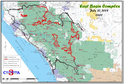
The Basin fire in the Big Sur area of California is now 133,709 acres and is 70% contained. A fresh incident management team, Jeanne Pincha-Tulley's, assumed command of the fire at 6 p.m. on Saturday and more information is now available for the public. This map is current as of 6 a.m. this morning.

The map shows that the firefighters have completed firing out from the dozer lines around the White Oaks slopover north of the Mira Observatory. One of the higher priorities they are working on now is burning out from the dozer lines just north of Arroyo Seco.

Saturday night's update:
Successful burnout operations continued today on the western edge of the fire between Piney Creek and Arroyo Seco west of Carmel Valley Road, and east of Devil's Peak on the north edge of the fire. Burning operations will continue into the night.

Saturday, July 19, 2008

Wildfire news, July 19

Fired Hawaii firefighter suspected of arson

A former Honolulu firefighter is suspected of starting three vegetation fires on Thursday. He was fired for trying to manipulate the outcome of his random drug test. The Hawaii Kai fire department put out three fires totaling eight acres that started within a 4 hour period. Police arrested Kenton F. Leong, 41, a 17-year veteran of the fire department, near the scene of the third fire. He was spotted by a policeman walking out of an area where a fire had just started.

South Carolina lookout towers

Only 40 of South Carolina's 160 fire lookout towers are still standing and groups are trying to save at least pieces of some of them for a museum. Most of the remaining towers have not been maintained since 1993 and are literally falling apart. When the towers were built decades ago, even wired telephones were rare and it took a while for fires to be reported. Now almost everybody on the road or out in the woods has a cell phone, so it's like having thousands of "lookouts".

Brush fires in Los Angeles

A couple of brush fires in the LA area received a lot of local attention yesterday, attracting a squadron of news helicopters documenting every pulaski stroke. One in La Tuna Canyon north of Burbank burned 15 acres and a Pasadena fire scorched 5 acres.

Pot growers threaten firefighters

Wildland firefighters have enough to worry about while trying to stay safe suppressing a fire, but a story in the Press Democrat gives several examples of marijuana growers in California threatening or even shooting at firefighters. The group of camo-wearing men that were trapped and burned on the Motion fire on Wednesday were suspected of tending a pot plantation. This is not a new problem. On the Big Bar fire on the Shasta-Trinity National Forest in 1987 we were warned to stay out of a certain area as much as possible because armed men had been seen there, most likely guarding a plantation.

Basin fire

InciWeb has this information, released last night, on the Basin fire east of Big Sur:

Burnout operations between Piney Creek and Arroyo Seco west of Carmel Valley Road began this afternoon and will continue this evening. Smoke is highly visible in this area.

Burnout operations continue east of Devil's Peak on the north edge of the fire, and will continue in the coming days as conditions permit. The northern edge of the fire is backing toward Carmel River inside the containment lines.

Fire activity has increased in the Rocky, Calaboose, and Piney Creek drainages due to dissipating smoke cover from the previous day's burnouts and increasing temperatures.
The Basin fire is 133,270 acres and is 70% contained.

Friday, July 18, 2008

California... exporting their smoke again

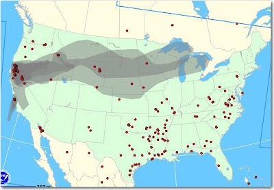
I wish California would keep their smoke. Today's map shows it going as far east as the Great Lakes.


Update @ 10:20 July 19:

Someone asked in the comments the source of the map. It's a NOAA product, available HERE. The site is somewhat flakey.... sometimes it works.

Wildfire news, July 18

HERE is an interesting story about an air attack organization in Texas.

The ENPLAN Wildfire Viewer combines fire perimeters, MODIS satellite heat detections, and a Google map. It is updated many times a day, but only has data for northern California. It would be great if this were available for the whole nation.

Yesterday Wildfire Today covered the survival of the California condors through the Big Sur fires. The condor sanctuary facility burned in the Basin fire and the non-profit Ventana Wildlife Society is seeking donations to rebuild it. The Monterey County Herald has more information.

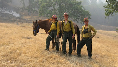
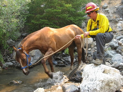
On Wednesday we covered the story of the horse that was rescued by a fire crew on the Mill fire, part of the Soda Complex on the Mendocino National Forest in northern California. We finally were able to dig up some photos. The horse is back with it's owner now.


Here is a video of the President's visit to Redding and the fires in northern California yesterday. It's a little raw, and almost 5 minutes, but it's pretty interesting. Notice the motorcade of 10-20 vehicles departing at high speed. They are traveling 700 yards from Air Force One to the smokejumper facility.


And speaking of the President's 747, Evergreen submitted their contract proposal for their 747 "Supertanker" to the U. S. Forest Service a week ago, but their Supertanker Sales Manager told us today that they have not heard back from the FS yet.

The Sacramento Bee has a story about "fire use fires", fires that are not totally suppressed, but are monitored and herded around. The SacBee of course refers to them as "let burn" fires, a term the federal land management agencies have hated ever since the fires of 1988 in the Yellowstone area.

The Monterey County Weekly has an interesting article about how residents in Big Sur during the Basin fire ignored evacuation orders and evaded law enforcement officers while protecting structures. I have a feeling that the comments at the bottom of the article are going to grow into a major discussion, with strong feelings on both sides of the issue.

UPDATE @ 1132 MT, July 18, 2008

As of late yesterday there was little fire activity on the Big Sur Basin fire with the exception of the burnout operation in the White Oaks area, east of Devils Peak, and near Tassajara Creek campground 1-2 miles southeast of the Tassajara Zen facility. The fire is 129,732 acres and is 65% contained. InciWeb is working today, for now at least:
Last night's burnout operations went well along Carmel Valley Road. Burnout operations are expected to extend southeast along the containment line as conditions permit, with units mopping up along Carmel Valley Road behind the fire.

Burnout operations will also proceed east of Devil's Peak on the north edge of the fire, and will continue in the coming days as conditions permit. The northern edge of the fire is backing slowly toward Carmel River inside the containment lines.

On the Cold Springs Fire in southwest Washington there was very little fire activity late yesterday--firefighters appear to be getting a handle on this one. Crews continue direct line construction in all divisions. One mile of line remains open. It is 7,933 acres and 30% contained.

Thursday, July 17, 2008

Aussie firefighters' orientation

The 45 firefighters from Australia and New Zealand finished their orientation on Thursday in Boise and traveled to Redding, California where they will be assigned to three incidents in Northern California. In addition to getting used to USA fire jargon and practices, they have to deal with jet lag. As one of them said:
On a side note, nearly everyone has got through the jet lag and are sleeping most of the night. It takes a few days to be able to sleep past 3am. The problem is that the sun stays up past 930 pm and it is daylight until after 10 pm so it is easy to loose track of time in the evening.

Firefighter rescues bear cub in fire, then begins treatment for rabies

Yesterday Wildfire Today brought you the story of the horse that was rescued by a crew on the Mill fire on the Mendocino National Forest. Now it's a bear.... a story not unlike the original Smokey Bear.

A Cal Fire Field Observer on the Moon fire in northern California, Adam Deem, found a bear cub while he was scouting the fire. The bear had some burns on his paws and was having difficulty walking. Deem looked for the cub's mother but could not find her, so he caught the bear and wrapped him in his brush jacket. In grabbing the cub, Deem received some scratches on his hands.

Deem cradled the bear in his arms as he drove his pickup to a staging area. From there he and the cub were driven to the Incident Command Post in Anderson. Deem said on the way to the ICP he comforted, petted and sweet-talked the little cub.

At the ICP the Medical Unit treated the bear for dehydration and let him lick a lollipop before a state Fish & Game wildlife biologist picked it up for the trip to the Sacramento area rescue shelter.

Deem and the bear developed a good rapport. "He was giving me some kisses," Deem said.

Unfortunately, some of those licks were on Deem’s scratched hands, which later forced him to undergo preventative treatment for rabies at Shasta Regional Medical Center in Redding. Deem said he had to have five rabies shots, and will need four more shots through next month.

“It’s absolutely worth it,” Deem said. “I don’t think anyone could have left that animal out there in that condition.”

The original Smokey Bear was a cub that was burned in the El Capitan National Forest in New Mexico.

UPDATE @ 0900 PT, July 18, 2008

Thanks to Tyler Dawn who let us know in the comments that the local media has a video story of the incident HERE.

California condors adapt to fire

Most of the 23 endangered California condors that were residing in the Big Sur area when the Basin and Indians fire began have been accounted for. Some of them were seen on the beach during the fire dining on a beached whale and a decaying California seal lion. Here is an excerpt from the MercuryNews.com:
Two rare California condor chicks have survived the Big Sur-based Basin Complex fire, enduring dense smoke but untouched by flames.

"We're ecstatic," said Kelly Sorenson of Ventana Wildlife Society, which monitors each bird along the vast central coast. "We're so incredibly relieved that two chicks survived."

The fate of the third remains unknown. Unlike the two survivors, who lived in coastal nests, the nest of the third chick was located in a more remote interior part of Ventana Wilderness Area, where the fire burned especially hot.

In a brief visit to one of the nests on Tuesday, wildlife biologist Joe Burnett found a chick "fat and happy in the cave. Mom and Dad have been keeping this chick full of food despite the disruption of the fire."

Among the rarest and most imperiled birds in the world, the chicks belonged to a small group of 23 wild condors in Big Sur. They are part of a reintroduction program administrated by the Ventana Wildlife Society. Only 151 wild condors remain in the world.

Because the young birds are only three months old - still covered in downy gray feathers yet already the size of chickens - they were too young to fly and escape the fire.

Sorenson and Burnett had hoped to rescue the birds ahead of the advancing fire, but were forced back by heat and smoke. For more than two weeks, they've been braced for bad news.

All but one of the older condors in the wilderness have been accounted for.

Wildland fire news, July 17

President plans flightseeing trip over fires

President Bush is expected to fly in to the Redding, California airport around 2 p.m. today. Then he and the Governor will cruise around in a helicopter looking at the fires. This will be the first time a sitting president has visited Redding since John F. Kennedy was there in 1963 for the dedication of the Whiskeytown Dam.

Bush will also attend a private Republican fund raiser in Napa.

UPDATE @ 2026 PT, July 17

A reporter for the Redding Record Searchlight, Ryan Sabalow, was at the Redding airport for the President's visit and was using his Blackberry to send live updates to the newspaper. Here is his description of when the President stopped by to see the jumpers:

Prez Bush just walked into smokejumper room. Walked up to John Casey, a 38-year-old jumper with almost 200 jumps in his career.

"I couldn't handle it," he said to Casey.

Bush asked him how many jumps. His eyes got wide at the number -- 200.

"I appreciate your service," Bush said.

Bush went around the room shaking hands and greeting the smokejumpers, who appeared busy sewing and prepping their chutes.

One was so fixed on his work that he apparently missed the president's approach from behind.

"I don't want to interrupt," Bush said, drawing laughter from reporters and firefighters alike.

Gov followed being giving kudos to the firefighters.

"Good to see you," he said to Casey. "Keep up the good work."


UPDATE @ 1413 PT, July 17:

Here is part of a transcript from a "press gaggle" that occurred today at 10:55 p.m. PT on Air Force One on the way to Redding, California. Mr. Stanzel is a spokesperson for the President. Under Secretary of Agriculture Mark Rey also participated in the gaggle.
Mr. STANZEL: At 2:30 p.m. today, when we arrive in California, the President will participate in a briefing on the California wildfires. That will be at -- in Redding, California. We'll have pool at the top, and he'll receive a briefing on the response efforts from federal, state and local officials.

And as you -- I'll let the two experts here talk a little bit about the fires themselves, but I would just note that on June 28th, the President signed an emergency declaration for the state of California; that is providing federal funding and support. And we have lots of information about the fires, and these are the single-largest -- this is the single-largest fire event in the history of California with over 1,300 square miles burned since June 21st.

After the President participates in that briefing on the California wildfires, he is going to participate in an aerial tour of the area, of Redding, and he will be joined in that by Governor Schwarzenegger. Administrator Paulison will also be there for an aerial tour of the Shasta-Trinity National Forest. And following the aerial tour, the -- Governor Schwarzenegger and the President will deliver brief remarks.

[...]

Q And square miles burned?

UNDER SECRETARY REY: I was afraid you were going to ask square miles burned -- it's about 900,000 acres burned. I'd have to get you the -- it's 66 acres per square mile, so -- (laughter) -- if you want the divide that number by 66 --

Q Can you give us an idea of what he'll see in the aerial tour?

UNDER SECRETARY REY: What he'll see in the aerial tour is areas of the Shasta-Trinity National Forest that have burned, as well as areas that have been thinned to reduce flammable materials. He'll also see a couple of thinning projects that did result in our ability to put out a fire more easily.

[...]

UNDER SECRETARY REY: Let me correct a number I gave you. It's 640 acres per square mile. So I've got to remember that. I have a hard time with the metric system and all that sort of stuff. I don't trust it.
The President will be briefed at the U.S. Forest Service smoke jumper base before he departs for his flightseeing tour. He will meet with Cal Fire Chief Ruben Garijalva, Randy Moore, U.S. Forest Service Regional Forester, Gen. William Wade from the National Guard, and Henry Renteria, director of the California Office of Emergency Services. After his briefing he will visit the smokejumper loft and say hello to the jumpers working on their chutes before he departs on a helicopter for a tour of the Shasta-Trinity National Forest.


Basin fire, Big Sur area

The satellites have detected quite a bit of heat north and south of the White Oaks area that is outside of yesterday's fire perimeter, apparently the result of quite a bit of firing from the dozer lines. The update from the fire late yesterday had this information:
Today's burnout operations went well on Chew's Ridge. Burning conditions were optimal and a combination of tools, including the helitorch, was used to meet today's objectives. It is expected that operations will extend east along the containment line to Carmel Valley Road tonight. Burnout operations in this area will continue through the coming days as weather conditions permit.

At the south end of the fire, along Carrizo Trail, the Cobra helicopter that is outfitted with an infrared camera found no remaining hotspots near the containment line.

Burnout operations also continued east of Devil's Peak on the north edge of the fire, and will continue in the coming days as conditions permit.

The King City Incident Command Post and Carmel Valley Spike Camp have been combined and relocated to Carmel Valley Road near Tassajara Road.
At a public meeting Tuesday night a Forest Service spokesman used technical jargon to explain the slopover in the White Oaks area:
"Two nights ago, we had a little oops," Buck Silva of the U.S. Forest Service told a group of more than 100 residents at a community meeting late Tuesday at Tularcitos Elementary School in Carmel Valley.

"We're making progress," he said. "We just had this little pooch-out that delayed us a couple of days."
I can't find "a little oops" or "pooch-out" in the glossary in the Fireline Handbook.

The fire is 122,980 acres and is 61% contained. The map below is of the White Oaks area.


This map shows how much heat (in red) was detected by the satellites outside the last perimeter (in yellow) uploaded by the incident management team. I am going to assume that all of the heat shown shown outside the perimeter, including that on the northeast side in the White Oaks area, was created by the burnouts from the dozer lines.


Cold Springs fire, Mt. Adams, Washington

The spread of the Cold Springs fire on the lower slopes of Mt. Adams in southwest Washington has slowed. After quickly burning over 7,000 acres, it is now about 7,900 acres. Yesterday morning it was 5% contained, but that percentage has increased since then.