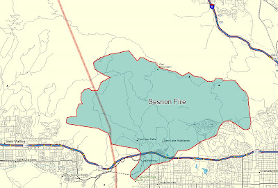
The Sesnon fire has grown over the last 24 hours to an officially reported size of 13,285 acres, but it is probably more than 14,500 acres. The Santa Ana winds have decreased, making it possible to obtain 20% containment. The fire consumed 47 structures, with 15 of them being residences. All evacuations have been lifted.
Fire department personnel initially considered the possibility that the fire could burn south across Highway 101 and eventually all the way to the ocean. They even went so far as to identify Branches on the path that the fire could have taken to the Big Pacific Fuel Break.
Here is a updated map that we put together today that shows the approximate perimeter of the Sesnon fire at sunset on Tuesday. Click on it to see a much larger version. As far as we know, there are no other semi-accurate maps of this fire available to the public. The ridiculous map on the LA County web site is absurdly inaccurate to the point of being insulting. The citizens affected by this fire deserve better.

Marek Fire
This fire has not grown in the last 24 hours and as of late on Tuesday there was no significant fire activity. It is still 4,824 acres and is 80% contained. The fire burned 44 structures and there is still a mandatory evacuation order for Lopez Canyon. More information is at the LA County web site.
The map below, created by the Incident Management Team, is looking toward the northeast. AT the bottom of the image is the intersection of the 118 and 210 freeways.


No comments:
Post a Comment