.

Wednesday, October 15, 2008

California: Update on Sesnon and Marek fires, October 15

Sesnon Fire

The Sesnon fire has grown over the last 24 hours to an officially reported size of 13,285 acres, but it is probably more than 14,500 acres. The Santa Ana winds have decreased, making it possible to obtain 20% containment. The fire consumed 47 structures, with 15 of them being residences. All evacuations have been lifted.

Fire department personnel initially considered the possibility that the fire could burn south across Highway 101 and eventually all the way to the ocean. They even went so far as to identify Branches on the path that the fire could have taken to the Big Pacific Fuel Break.

Here is a updated map that we put together today that shows the approximate perimeter of the Sesnon fire at sunset on Tuesday. Click on it to see a much larger version. As far as we know, there are no other semi-accurate maps of this fire available to the public. The ridiculous map on the LA County web site is absurdly inaccurate to the point of being insulting. The citizens affected by this fire deserve better.


Marek Fire

This fire has not grown in the last 24 hours and as of late on Tuesday there was no significant fire activity. It is still 4,824 acres and is 80% contained. The fire burned 44 structures and there is still a mandatory evacuation order for Lopez Canyon. More information is at the LA County web site.

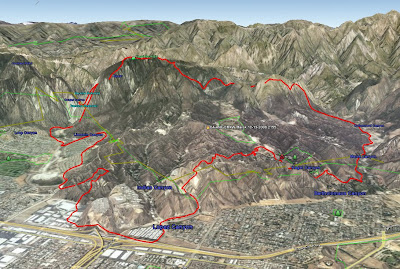
The map below, created by the Incident Management Team, is looking toward the northeast. AT the bottom of the image is the intersection of the 118 and 210 freeways.

LA City engine crews survive entrapment

Two engine crews from Los Angeles County City Fire Department had a very close call on the Sesnon fire Monday morning. From the LA Times:
In an instant, flames surround L.A. fire crew

The captain of the trapped engine company faces life-and-death decisions as erratic winds fan canyon blaze. 'The fire exploded and started raining embers . . . It was incredible,' he says.

By Robert J. Lopez, Los Angeles Times Staff Writer
October 15, 2008

It was one of those moments firefighters fear most.

Los Angeles Fire Capt. Scott Gould was riding inside Engine 228 as it maneuvered along a winding canyon above Porter Ranch. He was talking on the radio with Capt. Richard Brunson, who was just ahead in Engine 8.

Commanding the first two units to arrive at the Sesnon fire Monday morning, the captains were coordinating their assault on the wind-whipped blaze. What had been a half-acre fire only a few minutes earlier was now 20 acres and growing.

As Brunson reached the flames along Limekiln Canyon, Gould could see that a spot fire had broken out several hundred yards below. If the new fire got going, he recalled thinking, Brunson would be trapped. Gould and his crew pulled a hose from their engine and began trying to knock down the blaze.

In what seemed like only an instant, the two captains later recalled, flames were everywhere.

"The fire exploded and started raining embers all around that canyon," Gould said Tuesday. "It was incredible. All the ridge lines were going up in flames."

Brunson, meanwhile, faced another wall of fire, fanned by winds in excess of 30 mph. He decided to try pulling back a couple miles down the road, where he and his crew could join other units to protect structures and help with evacuations.

"We went into defensive mode," he said.

But as he headed down the canyon, he saw that flames were beginning to devour brush all around Gould and his crew. Brunson jumped out of his engine and ran toward Gould.

"Drop your hose and leave!" he recalled shouting. "Get the hell out of here!"

Brunson's engine led the way down the road as Gould and his crew jumped in the cab of their truck. But it was too late. It was as if incendiary bombs were exploding everywhere, Gould said.

"It just started spotting all around," he said of the flames.

Gould weighed his options and knew they weren't good. "Engine 228 is trapped," he barked into his radio. "We're surrounded."

Firefighter Paul Clark, who was with Gould, said that the flames were on both sides of the road.

"It was safer to stay where we were," he said.

Looking at his map book, Gould radioed in his coordinates and asked for a "priority" water drop. He and his three-man crew hunkered down in the cab of their engine as flames raced around them.

The smoke was so thick the crew could see only a few feet in front of them, and the water-dropping helicopter overhead couldn't see them either.

"Can you spot the copter so we can get a drop on you?" Gould recalled the dispatcher asking.

For the next 15 minutes, Gould and his crew kept shifting their fire engine into small areas that were partially burned -- offering a bit of protection -- as the wind fanned the flames back and forth across the canyon.

"We were lucky because of the winds," Clark said. "It didn't light everything off at the same time."

In the end, Gould said, it was the erratic winds that allowed his crew to escape.

They received word from the helicopter that the road was clear. He and his men made it out and spent the rest of the day fighting the Sesnon fire.

Photo by Louie

Tuesday, October 14, 2008

Wildfire news, October 14

See the post submitted earlier today for an update and maps on the Marek and Sesnon fires north of Los Angeles, California.


Bob Mutch receives the IAWF’s Wildland Fire Safety Award

Bob Mutch receives the IAWF’s Wildland Fire Safety Award from president Chuck Bushey at the recent “The Fires of ’88: Yellowstone and Beyond” conference.

From the International Association of Wildland Fire:
From his early days at what was then known as the US Forest Service’s Northern Forest Fire Laboratory in Missoula, Montana to his various roles within that agencies fire management program Bob’s distinguished 38-year career has continually championed both firefighter and public safety.

His involvement in developing the Fire Behavior Service Center concept in the early 1980’s further illustrates his active involvement and commitment to wildland firefighter safety. Even his very early work within the US Forest Service’s wilderness fire program can now be viewed as contributing significantly to firefighter and public fire safety, while at the same time helping to change agency policy and return fire as an ecological process to wildlands.

Following his agency retirement Bob continued his fire career as a renowned wildland fire consultant promoting wildland fire safety.

New Camp Pendleton Fire Forces Closure of I-5

Camp Pendleton, the Marine base about 40 miles north of San Diego, has been plagued by wildland fires over the last several days. Here is a report from KTLA:
A new wildfire is burning at Camp Pendleton, forcing the closure of Interstate 5 for 20 miles in both directions. CHP Officer Rob Sanchez says the freeway was closed once Tuesday morning, briefly reopened and then closed again after
winds shifted and the fire flared up.

A North County Transit spokesman says Amtrak and Metrolink trains are being held at Oceanside and at San Clemente stations.

Marine Cpl. Priscilla Vitale says it is not immediately known how many acres are involved in the new fire, but she says no structures are threatened.

It is the third fire to start on the base in two days. Vitale says two fires started Monday on the base's training ranges; she says neither fire was caused by any type of military training. More than 3,000 acres have been scorched; there is about 25 percent containment.

An evacuation order for about 1,500 homes in Oceanside. A spokeswoman for the City of Oceanside says some residents have been allowed to briefly return to neighborhoods near the base to get their pets and collect personal items.

Marine spokesman 2nd Lt. Riley Whaling says an unknown number of families were evacuated Monday by military police from a housing area threatened by the fire.

The Juliet fire, named for the training area where it started, was reported some time after 3 p.m. Monday. It was not immediately clear how the fire started.

Whaling said a second fire was burning on the base in a training area. No buildings were threatened by that fire.

Update on the Angel fire in San Francisco Bay

CHRISTOPHER CHUNG / The Press Democrat
An inmate fire crew mops up Monday after a blaze on Angel Island. The fire charred more than half of the island but spared scores of historic structures.

On October 12 Wildfire Today told you about the fire burning on Angel Island in San Francisco Bay. Here is an update, courtesy of the Press Democrat.
Firefighters working through the night on Angel Island brought the wildfire that burned more than half the island to 90 percent containment by Tuesday morning, a fire officials said Tuesday.

Photo from October 12.

Fire crews expect to have the fire fully contained by Tuesday evening.

Crews will be on the island for the next few days, making sure no hot spots remain to threaten flare ups.

What started the wildland blaze remains under investigation.

“We’re focusing on the area on the east side, where there was a campsite. We need to interview the campers,” said Kent Julin, a forestry with Marin County Fire Department.

On Tuesday morning there was little evidence of the conflagration Monday when flames swept over half the island, created a glow in the sky and filled the air above San Francisco Bay with heavy smoke.

There was no lingering smoke Tuesday as firefighters worked under clear, blue skies, Julin said.in the bay just off the Marin County coast.

A force of nearly 400 firefighters saved the state park's historic buildings from destruction.

Colorado: five homes burn near Hotchkiss

From the Grand Junction Sentinel:
Tuesday, October 14, 2008

A wildfire that started Thursday afternoon destroyed five homes and at least a half-dozen outbuildings on Redlands Mesa near Hotchkiss before it was fully contained Sunday, Delta County emergency manager Rob Fiedler said.

Fiedler said only three of the homes were occupied.

The fire was likely caused by humans, Fiedler said, and is still under investigation.

“We had eyewitnesses who reported seeing some human activity and investigators are still checking out all leads and running them down to check the veracity,” he said. “But it has never been considered malicious from the outset.”

With 45 to 50 mph winds pushing the fire early on, it spread from 80 acres Thursday, when 34 homes in its path were evacuated, to approximately 240 acres Friday. By Friday evening the fire was 40 percent contained. No one was injured in the fire, but it took the lives of one cat and three dogs.

Fiedler said air tankers from the Bureau of Land Management dropped flame retardant on the fire Thursday and Friday. More than 100 firefighters from all Delta County fire departments fought the blaze along with a 20-person hand crew from the Buena Vista Correctional Facility.

The chance for wildfires still exists, Fiedler said.

“Things are still very dry below 8,500 feet,” he said.

West Virginia: Coal refuse fire

Wildfire Today has reported on two previous fires in coal refuse. Here is another one, courtesy of WCHS Radio 58. We are fascinated by these fires. They can pop up unexpectedly in surprising locations, they can cover many acres, they can burn for dozens of years, and they can be very difficult to put out.
(Glen Jean) -- Firefighters say there's very little they can do to stop a coal waste dump in Fayette County from burning. The gob pile caught fire about three weeks ago and has been smoldering underground ever since.

Mt. Hope Volunteer Fire Chief Shane Wheeler says the process probably started with spontaneous combustion after the area was reclaimed with a thick coating of sawdust, replanted with vegetation.

"Pressure over time caused the coal under that saw dust to catch fire," said Wheeler.

The chief says there's really no good way to put out the fire. Therefore the strategy has been to just let it burn within a set perimeter.

"The big hazard would be the ground giving way. You walk across it and you could literally fall into a burning crevice,” said Wheeler. "There's been some cases where people have been killed trying to put them out, where bulldozers have literally been swallowed up."

Some gob piles will burn for years. The biggest danger is when the fire reaches into the air and jumps fire breaks into the forest. Right now, the leaves are dry, brittle, and littering the forest floor. The gob pile fire is about 25-acres and Sunday it jumped into a nearby woodlot, taking out another 25-acres of woods.

Wheeler says the best they can do is continue to improve the fire line they've cut around the perimeter and hope it holds the fire to the interior.

Montana: Prepare, Stay, and Defend

On May 30 Wildfire Today told you about this concept being discussed in Montana. We just received a report from Alan Tresemer of Painted Rocks Fire and Rescue, one of the speakers at a conference where it was presented:
Just thought I'd update you on the presentation at the Idaho Wildland Fire Conference in Boise this week. Keith Harrap (Executive Director Ops/Support, New South Wales Fire Service) and I were the keynote speakers and covered the Australian Prepare, Stay, and Defend system for wildland fires. Idaho State Lands really is ahead of the pack on this.

About a month ago, Steve Kimball sent out the Tasmanian "Bushfire" DVD to all fire chiefs and county commissions, so the audience was primed to hear the details. Keith covered the big picture of how Australia has dealt with the issue and their great success at reducing deaths, injuries, and loss of property by preparing homes (FireWise) and having people stay at home to keep their homes from burning. I related our fire company's success at implementing this system in our small Montana community of Painted Rocks. There were around 250 attendees representing the bulk of Idaho's fire services.

The message was very well received and Idaho is on its way to finding better ways of protecting its communities. Idaho Lands really deserves a pat on the back for their proactive efforts.

Alan Tresemer
Batt. Chief
Painted Rocks Fire & Rescue, Montana
Thanks Alan--we're glad it went well. We used to call it "Shelter in Place", but Prepare, Stay, and Defend is a better term.

California: Update on Sesnon and Marek fires

Update @ 11:30 p.m. Tuesday

The incident management team posted a perimeter map of the Marek fire. It shows the perimeter as of Monday night. In this view, we are looking toward the northeast. Click on it to see a larger version.

The Sesnon fire has now grown to 13,285 acres. Lighter winds during the day on Tuesday enabled firefighters to make some headway constructing firelines on the east flank. No containment figure has been announced.

The Sesnon fire is still listed at 4,824 acres and 70% containment.

Update @ 4:20 p.m. Tuesday

After realizing that LA County FD and LA City FD were not going to produce any usable maps of the fires, using our sources within the fire community, we produced a rough map of our own based on where the fire was at about 9 p.m. PT Monday night . The perimeters are only approximate, but they are a little better than what has been available to the public. Click on the map to see a much larger version.


7:44 a.m. PT, Tuesday


MAPS

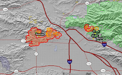
Here is a map of the Sesnon and Marek fires. It shows heat, in red, orange, and black, detected by satellites last night, with the red areas being the most recently burned. Click on the map to see a larger version.


The map below of the Sesnon fire is provided by LA County Fire Department and it shows only an approximate location of the fire. It should update automatically with data provided by the LACFD if you refresh your browser.


View Larger Map

The map below of the Marek fire is provided by LA County Fire Department and it shows only an approximate location of the fire. It should update automatically with data provided by the LACFD if you refresh your browser.


View Larger Map

It is ridiculous that two of the largest fire departments in the world (Los Angeles City FD and Los Angeles County FD), with fires going that are affecting millions of people and have killed two, are capable of only producing these two pitiful, inaccurate, Google maps. The satellite map at the top of the post is far more helpful. These fires have been burning for 2 days. There is no excuse for not providing better information to thier customers.

EVACUATION, SHELTERS, AND TRAFFIC

Local residents can get information about fire-related traffic, evacuations, and shelters by calling a recording provided by the LA Fire Department at 800-439-2909.

SESNON FIRE FACTS

The fire has burned 9,872 acres, is 5% 0% contained, 19 structures have burned, and it is being fought by 1,400 firefighters. This fire is still very active and numerous residences are threatened.

MAREK FIRE FACTS

This fire has burned 4,824 acres and is 70% contained, with 1,355 firefighters assigned. 39 structures have burned, with 38 of them being mobile homes.

WEATHER

Current weather in the fire area:
Newhall Pass @ 6:35 a.m.: winds east @ 6 with gusts to 31, RH 18%.
Little Tujunga @ 6:54 a.m.: winds NE @ 3 with gusts to 33, RH 12%

A Red Flag warning is valid until 10 p.m. Wednesday for strong Santa Ana winds and low humidities.

A wind warning is in effect until noon for LA, Ventura, Orange Counties, Mountains, and Inland Empire for NE winds from 30-45 mph, gusting to 70.

A wind advisory is in effect until 3 p.m. for the rest of southern California.


Photo courtesy of LA Times

Monday, October 13, 2008

California: Sesnon fire

Update @ 11:50 p.m. Monday

The Sesnon fire has now burned 5,000 acres. The map below in the 1:33 p.m. update revises automatically with data provided by LA County Fire Department. Local residents can get information about fire-related traffic, evacuations, and shelters by calling a recording provided by the LA Fire Department at 800-439-2909. A Newhall pass weather station at 10:35 p.m. showed SSW winds at 6 mph with gusts up to 22. The RH was 17%. The Santa Ana winds are expected to increase tonight between 11 p.m. and 11 a.m.

Update @ 4:50 p.m. PT Monday

At a news conference that is just now concluding, officials announced:
  • The winds tonight after 11:00 p.m. will have gusts exceeding 60 mph.
  • The fire is being manged in a Unified Command, with LA City, LA County, and Ventura County.
  • There are about 800 firefighters assigned.
  • Damage assessment teams are working in the burned areas, but there is no official count on damaged structures yet.

Update @ 3:39 p.m. MT Monday

Inspector Ron Haralson of the LA County FD just announced that the Sesnon fire is over 3,000 acres. If needed, and wind permitting, he said some of the helicopters will continue to fight fire after dark tonight.

There was a traffic collision on the 118 freeway today that resulted in a fatality. It may have been related to reduced visibility caused by the smoke. If so, this would be the second fatality caused by this fire bust. The first was the homeless person that died in his cardboard shelter.

At a news conference earlier today, one of the fire chiefs raised the possibility that one of their objectives was to keep the fire from burning all the way to the Pacific Ocean. Holy Crap!

The Santa Ana winds, which have decreased a bit today, but are still too strong for effective air attack, will be their strongest between 11 p.m. tonight and 11 p.m. tomorrow (Tuesday).

Local residents can get information about fire-related traffic, evacuations, and shelters by calling a recording provided by the LA Fire Department at 800-439-2909. Other information about evacuations can be found at the LA County FD web site.

Update @ 2:30 p.m. PT Monday


The Sesnon fire at 3:15 p.m. MT Monday

The Sesnon fire is now over 2,000 acres. The winds have decreased a bit, but are still pretty strong.

A weather update now predicts that the winds will continue through Tuesday night for some areas in southern California and into Wednesday night for other areas..

Update @ 1:33 p.m. PT Monday

Here is a map showing the approximate location of the Sesnon fire in the Porter Ranch area, current as of about 1 p.m. Monday...provided by Los Angeles County Fire Department. This map should update automatically.


View Larger Map

Wildfire news, October 13

New fire in southern California: Sesnon Fire

The heel of the Sesnon fire at 1:30 p.m., Monday, about 2 hours after it started.

A new fire started around 10:30 a.m. PT about 12 miles west of the Marek fire. It is in the Oak Oat Mountain area northeast of Porter Ranch. Observing the live video from the Los Angeles CBS TV station, it is spreading rapidly in mixed grass and oak vegetation. The fire is threatening some important radio repeaters on Oak Oat Mountain, some of them belonging to LA County Fire Department and are being used currently on the going fires. (at 12:15 PT, this fire was 750 acres.)

Two Super Scooper air tankers are dropping on the fire, but they are ineffective since the wind is blowing the water horizontally away from their targets. The Sikorsky Sky Crane helicopters are more effective.

As forecast, the Santa Ana winds have decreased a bit, but they are still blowing and should increase Monday evening. The red flag warning has been extended to 10 p.m. Wednesday.

Live video comes and goes, but it has been seen on local NBC and ABC stations.

Angel Island fire


This fire on an island in San Francisco bay that Wildfire Today told you about yesterday, is now 250 acres. The local ABC TV station has some excellent photos. HERE is a web cam view of the fire.

Assigned to the fire are 200 personnel, at least 8 engines, 2 helicopters and several hand crews. Additional resources have been ordered and as of yet, no structures have burned. The resources are staging and waiting for ferries and boats to transport them across the bay to the island.

California: Marek fire update, October 13

Update @ 11:55 p.m. Monday

There has been no recent update on acreage. Local residents can get information about fire-related traffic, evacuations, and shelters by calling a recording provided by the LA Fire Department at 800-439-2909. A Newhall pass weather station at 10:35 p.m. showed SSW winds at 6 mph with gusts up to 22. The RH was 17%. The Santa Ana winds are expected to increase tonight between 11 p.m. and 11 a.m.

Update @ 4:50 p.m. PT Monday

At a news conference that is just now concluding, officials announced:
  • The winds tonight will have gusts exceeding 60 mph.
  • Tonight's operational period will be very challenging.
  • The fire has now burned 4,726 acres.
  • They repeated the possibility that the fire could burn west to the 101 freeway, or even cross it and burn all the way the Pacific Ocean.
Update @ 4:00 p.m. PT Monday

The fire has now burned 4,000 4,726 acres. The Santa Ana winds, which have decreased a bit today, will be their strongest between 11 p.m. tonight and 11 p.m. tomorrow (Tuesday). Information about evacuations can be found at the LA County FD web site.

Update @ 1:38 p.m. PT Monday

Here is a map showing the approximate location of the Marek fire as of 9:45 a.m. Monday... provided by LA County Fire Department.


View Larger Map

Update @ 1:11 p.m. PT

LA Fire Department has a map of the areas that are being evacuated.

Update @ 12:07 p.m. PT

The one person known to be killed on the Marek fire was a homeless, transient, male who was living in a cardboard shelter.

Update @ 11:58 a.m. PT

In a news conference the Mayor of Los Angeles just announced there has been one fatality "on the city side" of the fire, which is on both LA city and County jurisdictions. It occurred on or near Foothill Blvd., but the identity of the male victim has not been released.

========================

8:30 a.m. PT


In the evening on Sunday the Santa Ana winds had decreased on this fire that is also known as the Little Tujunga fire. The firefighters had made good progress and had even stopped the spread at around 2,200 acres, but as predicted, the winds increased overnight, causing the fire to spot over the shaky fire lines at 4:30 Monday morning pushing the fire toward the west across the 210 freeway, causing the closure of the 210 and the 118 highways as well as other primary roads. HERE is information about road closures. Many schools in the area are closed as well. Large areas are under mandatory evacuation orders. KTLA has a list of evacuation centers, as well as freeway and school closures.

The latest size given by the public information officers is 3,200 3,500 acres with 5% containment, but it is probably larger, since the fire is spreading rapidly. Numerous large structures and large trucks have been destroyed in industrial complexes, ignited by spotting and 200-foot flames. Some subdivisions of homes surrounded on one or two sides by brush are immediately threatened by fire that is within a few hundred feet. There are 60 strike teams of engines on scene or ordered, with 200 engines working the fire this morning.

Aircraft have been working the fire since 5 a.m. this morning, but the air tankers had to be grounded at around 8:30 a.m. due to the strong winds. The helicopters are still dropping water, trying to limit the number of structures that are destroyed.

On live aerial video provided by Los Angeles TV stations we have seen individual mobile homes in the middle of large mobile home parks burning, the result of long-distance spotting. In another mobile home park, the Valley Terrace park, we counted at least 25 mobile homes that had burned.

The Santa Ana winds are expected to continue through at least Tuesday with red flag warning in effect for much of southern California. Wind gusts have been reported at up to 75 mph in one of the mountain passes.

Opliger's Type 1 Incident Management Team, which was already prepositioned, will inbrief at 1400 and will assume command at 1800 today. Dietrich's Type 1 Team is staged and standing by at the Ontario Fire Cache.

Sunday, October 12, 2008

California: fire on Angel Island, San Francisco Bay


A vegetation fire is burning on Angel Island, an island in San Francisco Bay. Reports say it is 10 to 50 acres and has been burning since about 9 p.m. PT Sunday night. The fire can be seen from web cams, HERE, HERE and HERE. On the cams, the fire appears to be burning pretty intensely as of 11:10 PT Sunday night. This link has local wind speed and direction as well as a cam image that appears to be compromised by a reflection, at least at night.

Marin County fire department is responsible for fire suppression on the 768-acre island. They have already sent firefighters, and engines have been ferried to the fire, which can be seen from many areas around the Bay. Fire boats from Tiburon and Sausalito are on scene as well as the Coast Guard. Hand crews and additional engines have been requested by the firefighters on the island.

Click on the maps to see larger versions.