The fires in the greater Los Angeles area are still burning actively with little containment. Overnight the winds have decreased and an inversion is trapping much of the smoke near the ground. However in some areas the fire is burning intensely and the smoke is breaking through the inversion layer.
WEATHER:
A wind advisory is in effect until 9:00 a.m. for northeast winds at 15-30 mph. There is a Red Flag warning effective until 4:00 p.m. today, for low humidities and high temperatures around 90
UPDATE @ 3:30 p.m. Saturday
Here is a map produced by the LA Times. We can't vouch for it's accuracy and it's pretty crude, but it's one of the better ones we've seen, sadly.
View Larger Map
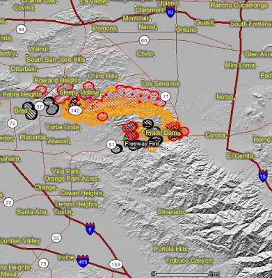
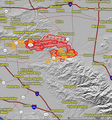
Here is an updated satellite map showing the latest thermal imagery. It shows that the fire has moved farther to the north on the northwest side, in the Chino Hills, Sleepy Hollow, Rowland Heights, and highway 57 areas. The red colors show the most recent heat. Click on the map to see a larger version.

------------------------------------------------
 Thermal imagery map from a satellite Saturday night showing the fires in the Corona and Yorba Linda area. The red and orange areas show heat, with the red areas being the most recent. Click on the image to see a larger version of the map.
These two large fires are burning very close to each other and in fact may have burned together. They are now managed as one incident with the new name, "
Firefighters are conducting some large burnouts on the east side near 91 and 71. The fire is still active, especially in the Chino Hills and Yorba Linda areas. Early this morning some mobile homes burned in the Olinda Village in Carbon Canyon (Highway 142) on the northwest side of the fire.
A national Type 1 Incident Management Team will assume command of the fire tonight.
Residents who need information about evacuations can call 714-990-7732.

SAYRE FIRE (Sylmar, Newhall pass area)
 Above is a thermal imagery map from a satellite Saturday night showing the Sayre fire in the Sylmar and Newhall Pass area. The red, orange, and black areas show heat, with the red areas being the most recently burned. The dark gray areas are the fires from mid-October, the Marek and Sesnon fires. Click on the image to see a larger version of the map.
As you can see from the map above, the Sayer fire has burned into last month's Sesnon fire. The official size of the fire is 9,500 acres and it is 30% contained.
Search and rescue teams with cadaver dogs will be combing through the Oak Ridge mobile home park where 500 mobile homes were lost. They will be looking for the remains of anyone who was not able to evacuate. Even though some people are not accounted for, hopefully they are safe and no remains will be found. An evacuation hotline has been set up, (800) 439-2909.


5 comments:
The opening photo of the FF putting water on the fully involoved structures looks useless.I would have my lines out working on a defendable structure. I worked some S.Cal fires and rates of spread are unreal. I salute the crews there.
The LA Times uses data from www.fireimaging.com to produce their fire area maps. They give attribution to USDA Forest Service Riverside, Pacific Southwest Research Station. See this map for the Tea Fire- http://www.latimes.com/news/local/la-111508-me-sbfire-g,0,5001303.graphic
There's new fire mapping site (now in Beta)- http://firelocator.net/. It uses MS Virtual Earth, so you have to install the Silverlight display app.
I tried the firelocater site and I don't recommend it. It is very cumbersome and appears to be a work in progress. Also, the map of the Tea fire referenced in the second comment is very, very crude.
About the first comment referencing the structure... yes, it looks like the house is already a total loss.
Post a Comment