Sayre fire near Sylmar
UPDATE @ 2:00 p.m. PT Monday
Here is a new map provided by the incident management team. Their map is very similar to the one I made earlier, so I am pleased to see that theirs is accurate. LOL
---------------------------------
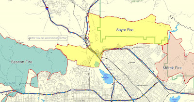
This fire is still active in the Placerita Canyon near Santa Clarita. It has burned 10,077 acres and is 40% contained. The fire connects the two large fires that burned last month, the Marek and Sesnon fires. We made the unofficial map of the Sayre fire below that shows the approximate locations of the three fires.
The residents of the Oak Ridge mobile home park, where 500 homes burned, will be bused into the park today and will be able to get their first looks at the site. Some of them still may not know if their mobile home burned until they arrive in the park today. They will have 10 minutes to look around and gather anything remaining that they want to salvage.
Freeway Complex near Corona, Yorba Linda, Anaheim, Chino Hills, Carbon Canyon, and Brea
UPDATE @ 1:48 p.m. PT Monday
Here is a new map of the Freeway Complex provided by the incident management team, as shown in Google Earth. We are looking toward the northwest.
---------------------------------
This fire is still active on the northwest side in the Diamond Bar and Tonner Canyon areas. It has burned 28,889 acres and is 40% contained. At least 120 homes have burned.
Our post from yesterday has a map of the Freeway fire that should still be current if you refresh your browser.
Tea fire near Montecito and Santa Barbara
UPDATE @ 1:55 p.m. PT Monday
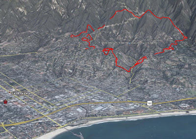
Here is an updated map of the Tea fire, provided by the incident management team. We are looking north.
Here is a map of just the south (populated) side of the Tea fire. We are looking straight down and north is at the top. You might be able to make out a few street names if you click on the map.
---------------------------------
All of the evacuation orders have been lifted for all but 260 homes. This fire started on Thursday, destroyed 210 residences, and burned 1,940 acres. It is 90% contained this morning but may be totally contained as early as tonight.
Westmont College lost 15 faculty houses, a dormitory complex, and its physics and psychology buildings. Officials of the college said over the weekend that they were busy assessing the damage, fencing off ruined buildings, and figuring out how soon the semester could resume.
How To Use Storytelling To Sell Dream Vacations
-
People do not buy trips based on hotel names or flight schedules. They buy
the feeling of escape, connection, and anticipation. Storytelling is one of
th...
1 day ago


2 comments:
Perimeters for Freeway/Tea/Sayre fires are finally up at GeoMAC.
We're mirroring their data plus the MODIS heat detects on a Google Map base at:
http://www.enplan.com/fires
Thanks for the link to the very cool enplan site.
Post a Comment