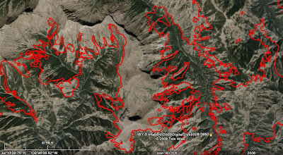
The map below is looking west, with Yellowstone Lake in the background, and shows the last perimeter uploaded by the incident management team on August 8. You can see that the amount of vegetation on the north side of the fire is pretty sparse since the elevation of the ridges is around 10,000 feet. On the east side the elevation is much lower and more vegetation is present. The south side along the highway is about 6,300 feet. If the fire should cross the highway, it would be very difficult firefighting.

Extreme mapping
As a former Situation Unit Leader and Infrared Imagery Interpreter, I have an appreciation of maps. The last few produced of the Gunbarrel fire perimeter are the most detailed fire perimeter maps I have ever seen. Every last nook, cranny, finger, island, and spot fire are documented. I believe the perimeters were provided by an Infrared Imagery Interpreter, poring over imagery taken by the U.S. Forest Service's fixed wing infrared aircraft. Usually perimeters are much smoother, tracing the outermost edges of small fingers of the fire, but the detail in these maps is amazing. Probably much more detail than is needed to manage the fire, but impressive nonetheless. It must have taken hours of slaving over a hot keyboard and mouse to make these perimeters.
Here is an example, a close up of the northwest portion of the fire. North is up, or at the top of the map. Click on it to see a larger version.


No comments:
Post a Comment