The fire is
This is the update from the incident management team this morning:
Yesterday's Activities: Containment on the fire increased by 21% yesterday for a total of 31% containment. There was minimal fire spread east, south and west with a total acreage of 9,701. Helicopters dropped 235,000 gallons of water on the fire. A cold front passed through the fire area late last night. Crews picked up some spots in the ski area. All other lines held. The continued burning of interior islands of fuels contributed to the smoke. Two additional radio repeaters were put up yesterday.See yesterday's report for a detailed map of the Cascade fire.
Today's Planned Activities: Crews will complete and secure line from Senia Creek north to Bald Mountain. They will also mop up with in one hundred feet of the line on the west, and north sides of the fire. Dozer lines will be improved and mop up will also take place around structures along the West Fork Road. Firefighters - on the ground and in the air will aggressively search and fight spot fires and continue to build and reinforce fireine.
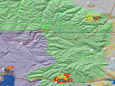
The map below shows heat, in red, orange, and black, detected by satellites last night on the Cascade, Gunbarrel, and LeHardy fires last night, with the red areas being the most recently burned. The yellow lines are the latest perimeters uploaded by the incident management teams. Click on the map to see a larger version.

Our new sponsor has yard signs and banners that you can put on your place of business or in your front yard that say "Thank You Firefighters-Residents of Red Lodge". T-shirts of the Cascade fire are also available. They also have yard signs and banners saying "Thank You Firefighters" that can be used near any fire.
 Gunbarrel fire, Wyoming
UPDATE @ 2:30 p.m. MT Aug. 2
From the incident management team:
On most days the fire has been most active in late afternoon, so it has not yet today shown its full intensity. However, so far buildings in the drainages closest to the fire are doing well. Some sprinklers are at work in Moss Creek to complement the fire hoses and pumps installed in the last couple days. Because of the complicated air flow this morning, no additional burning out was done around Absaroka Lodge. Again today firefighters are working hard to remove brush, install hoses and pumps, and otherwise prepare for the possibility fire will approach buildings.
The fire has moved east as far as the highest upper reaches of Clearwater Creek.
UPDATE @ 11:50 a.m. MT Aug. 2
The incident management team released new information this morning:
Fire Activity: The 15,500-acre fire was more active yesterday than fuel conditions and area weather would typically imply. Several pulses spread downhill and to the south, despite upper winds pushing the fire northeast. The fire is large enough that at times it is a strong influence on nearby weather. Today’s forecast includes a red flag fire warning for strong, dry winds.
Management Actions: Firefighters expect a second day of high-energy firefighting today. Yesterday afternoon and evening as fire approached they burned out around some of Absaroka Lodge and for about a mile along the highway. Water drops from several helicopters supported them.
Today firefighters plan similar operations. Patrol, preparations, and burn out are planned around buildings from Goff Lodge to Aspen Creek, including in Moss Creek. Locations will evolve in response to fire behavior.
========================
9:10 a.m. MT Aug. 2
The Gunbarrel fire has been very active on the south and east sides over the last 24 hours. The size is still being reported as 9,560 acres and it is about 6-7 miles from the east entrance to Yellowstone National Park. Yesterday's report has the map that is still the most current available. The fire is a "fire use" fire, meaning the firefighters are not totally suppressing it as long as it remains in their "maximum management area".
From the incident management team last night at 9:45 p.m.:
August 1, 2008, 9:45 p.m.From the Casper Star-Tribune:
Guests Temporarily Depart Two Lodges to Facilitate Firefighting Update: Advsiory for Tomorrow
The Gunbarrel fire spread aggressively today. With that in mind, residents and campers on both sides of the North Fork Shoshone between Chimney Rock and Wapiti Ranger Station are encouraged to recognize the possibility the fire will spread quickly again tomorrow afternoon. Residents are encouraged to be prepared in case any additional evacuations become necessary tomorrow.
·· This is not an evacuation notice. However there is always the possibility that rapid fire spread could make evacuation necessary. Please be prepared.
Current fire status: Firefighters have burned out around Absaroka Lodge. The operation went well
Fire has not spread south toward Elephant Head Lodge in several hours, and remains about a third of a mile north of the buildings.
The fire is close to the road on the north side of the river for about three miles east of the Elephant Head Lodge as far as Newton Creek. From Newton Creek further east another two miles to Moss Creek, the fire is about a quarter mile north of the road.
In Moss Creek fire remains north of the fireline constructed this afternoon, which is above the highest cabin. Engine crews are using pumps, hoses, and sprinklers to raise the humidity along the developed portion of Moss Creek.
Though winds from the southwest and west are pushing the Gunbarrel Fire mostly to the north and east, the southern edge of the fire continues to creep downhill toward the North Fork corridor, said Terry Root, Wapiti district ranger for the Shoshone National Forest.
Winds gusted to more than 60 mph along ridgelines Wednesday night, Root said, pushing the fire into an extremely active phase and raising concerns among fire managers about defending lodges and cabins to the south.
Root said the fire was at times spotting, or starting in new locations from blown embers, at distances of a half-mile.
"It seemed fairly scary, and it had me pretty nervous," he said, adding that further assessments Thursday left fire managers optimistic that it would continue mostly north and east, away from structures to the south.
"Our strategy is to let Mother Nature do its thing, as long as it doesn't cause problems for people," said Todd Richardson, deputy incident commander of a team of about 100 people working on the Park County blaze.
LeHardy fire, Yellowstone National Park
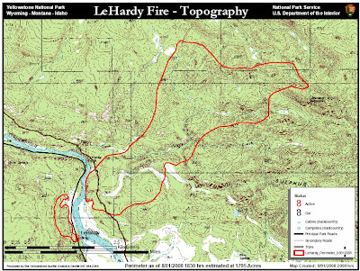
This fire in Yellowstone National Park north of Yellowstone Lake spread quite a bit to the northeast yesterday and is now 1,795 acres. It is moving toward old burns of 1988, as well as the East (18,050 a.) and Grizzly (4,460 a.) fires of 2003. The Grand Loop road is now open. The National Weather Service has issued a Red Flag Warning for Yellowstone National Park for Noon to 9:00 p.m. Saturday. Firefighters are preparing for another day of active fire behavior and fire growth.
 Telegraph fire, California
All evacuation orders for the Telegraph fire have been lifted. The acreage is listed as 34,034 and it is 80% contained. They are still showing as being threatened 2,000 residences in the communities of Midpines, Briceburg, Mariposa, Greenley Hill, Coulterville, Bear Valley, and Mt. Bullion Camp. Assigned to the fire are 4,057 people, 350 engines, and 94 hand crews. The current map can be found HERE.
Al Golub took some excellent photos of the fire and assembled them into a slide program. It's worth viewing HERE.
Telegraph fire T-shirts are available HERE.


No comments:
Post a Comment