UPDATE @ 11:14 a.m. MT August 3
Here is an update from the Park this morning:
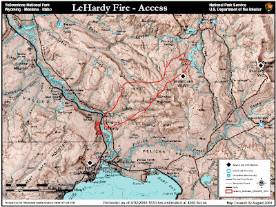
LeHardy Fire In Yellowstone Grows To 4,260 AcresThe map shows the fire perimeter as of 6:30 p.m. August 2; 4,260 acres.
Gusty winds and low humidity resulted in a very active fire day Saturday on the LeHardy Fire in Yellowstone National Park.
Visitors to Yellowstone witnessed huge, billowing smoke columns and torching as the LeHardy Fire grew over 2500 acres Saturday. A Red Flag Warning was issued for Saturday and the three weather components required came together to create the perfect conditions for rapid fire growth. Visitors lined the roads to take pictures of the impressive smoke columns and fire activity.
The fire is moving in a northeast direction into the back country away from Fishing Bridge. Hotshots and engine crews, with the help of water drops, are continuing to reinforce a control line along the section of the fire on the west bank of the Yellowstone River.
Cooler temperatures and possible isolated showers are predicted for Sunday, but firefighters are still preparing for a busy day. Mop up operations will continue on the west side of Grand Loop Road while crews on the east side will continue developing a buffer zone between the fire and Fishing Bridge.
Joe Krish, Incident Commander for the LeHardy Fire, stated “This is a long term fire. We expect it to be with us for awhile and are currently developing a long range strategy.”

=================================
9:21 a.m. MT, August 3
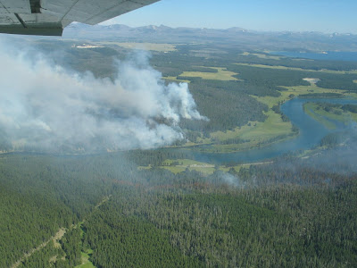
On Saturday the fire grew from 1,795 to 4,260 acres. The fire is north of Yellowstone Lake three miles from Fishing Bridge. Very little additional information is available but here is a photo taken on July 31.

Cascade fire, Red Lodge, Montana
Saturday's Activities: Containment on the fire increased to 33%. There was minimal fire spread east, south and west with a total acreage of 10,071. On the east side of the fire helicopters dropped 60,000 gallons of water, and 7,100 gallons of retardant. Six air tankers assisted with 15,000 gallons of retardant. Crews worked the north, south and east sides of the fire, mopping up on the north, working the Cole Creek quad spots on the east and continuing with line building on the south. The fire remained active till 10:00 p.m. and then laid down as the humidity increased.
Sunday's Planned Activities: Crews will continue to mop and secure the line from Senia Creek Trail east and along the north side of the fire. Resources will improve dozer line and establish control line from the end of the dozer line south towards West Fork Rock Creek. On the south side of the fire crews will hold and mop up line from Basin Creek trailhead to marsh area. Crews will construct handline from the lower marsh area south going direct and securing with black line as needed. Firefighters will be finding and putting all spots out. Burning snags within a 300 foot perimeter will be dropped and extinguished.
Gunbarrel Fire, west of Cody, WY
UPDATE 2:10 p.m. August 3
An update from the incident management team at 12:49 today:
The fire is now about 22,000 acres. Today is the third day in a row of red flag fire weather warnings for strong dry wind. About ten miles of the highway’s edge are now burned and tentatively secured. In the Wilderness, fire has spread east as far as the upper Sweetwater drainage in bug-killed timber that needs to burn.The last five words from the team are words that you seldom see in a news release from a fire. However, it is a "fire use" fire, and they would not have declared it as such unless it "needed to burn".
 ======================================
9:21 a.m. MT August 3
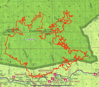
The fire was very active on Saturday, making some large runs on the east side. Fire crews are conducting burnouts around the Absaroka Mountain Lodge and other structures, and are installing sprinklers, pumps, and hose lays near vacation cabins. The last size reported was 15,529 acres, but this was before the fire expanded on Saturday.
The most recent map available, below, was produced at 1 a.m. August 2, but it does not include the large runs made on the east side on Saturday. If a more current map becomes available later today, we will replace this one.

Map
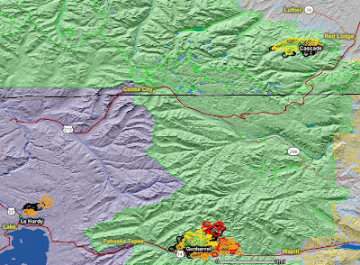
The map below shows the heat from the Cascade, Gunbarrel, and LeHardy fires, as detected by satellites last night. The last perimeters uploaded by the incident management teams are shown in yellow.


No comments:
Post a Comment