It's a handy little device about the size of a small digital camera andThis is a useful tool for people on the road a lot, including wildland firefighters who may travel for 21+ days at a time and don't always have the ability to phone home. The Laguna Hot Shots travel with a SPOT and even have a link to their SPOT map on their web site.is equipped with a GPS receiver and a radio transmitter. By pushing just one button, it can send via satellite a message that 1) you are OK, 2) that you need help, or 3) that you have an emergency and need 9-1-1 services. It sends your location with every message. It can also, optionally, send your location every 10 minutes, plotting your location and a track on Google Maps that can be viewed on the Internet by anyone to whom you give the web site address.
Within the last week, Google introduced two new free applications for certain mobile smartphones that can track your movements or send your real-time location to friends.
Google Latitude
From Google's Official Blog:
Latitude is a new feature for Google Maps on your mobile device. It's also an iGoogle gadget on your computer. Once you've opted in to Latitude, you can see the approximate location of your friends and loved ones who have decided to share their location with you. So now you can do things like see if your spouse is stuck in traffic on the way home from work, notice that a buddy is in town for the weekend, or take comfort in knowing that a loved one's flight landed safely, despite bad weather.It appears that after you opt-in and give permission for certain of your friends to follow your updates, the software in the smartphone, when activated, will continue to transmit your location to the Google Maps application at regular intervals. I'm reading between the lines here, however.
If you have a mobile smartphone, visit google.com/latitude on your phone's web browser to download the latest version of Google Maps for mobile with Latitude. Latitude is available on Blackberry, S60, and Windows Mobile, and will be available on Android in the next few days. We expect it will be coming to the iPhone, through Google Mobile App, very soon.
If you already have one of the smartphones listed above, this could be a cheap way for a wildland firefighter's family to know where they are when they are on the road fighting fires and saving lives. If they are not home by dinner time, check the Google Map and see where they are.
Google's My Tracks
Just introduced today, My Tracks will record your track on your Android-powered mobile phone as you move in an outdoor activity. You do not need a separate GPS receiver. Google emphasizes how it could be used for hiking, running, or bicycling. In fact, the application was written by a Google engineer at Boulder, Colorado, a former professional bicyclist, in his 20% time when employees are allowed to work on anything they want.
To use the application on your phone, you give it commands to begin and later end recording. It will track not only your position, but also your elevation. Then you can send the data to your Google Maps account or Google Docs where it can be viewed by anyone to whom you give permission. It can also display an elevation profile, which can be useful for training.
My Tracks only works on Android-powered phones, which for now, means you are limited to the T-Mobile G-1 mobile phone. And, T-Mobile does not have great coverage in many rural areas. HERE is a link to their coverage map. Be sure and look at the legend... many of the green areas are Roaming only. Other cell phone carriers may later support phones with the Android operating system.
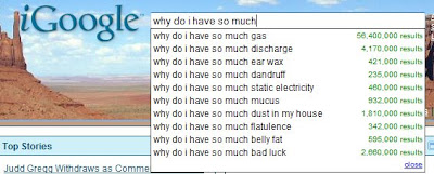
Google search: "Why do I have....."
And while we're on the subject of Google. You know how when typing in search terms, it offers suggestions for what you might be looking for? Here's an example of what it suggests if you begin typing "why do I have so much".


3 comments:
google is contributing so much to keep people together. Its product are so useful and profitable.
Thanks to you for the information and thanks to google to provide such a large scope of useful material.
The new "my tracks" app looks really cool! I have been using the app CardioTrainer for a couple months and then sharing by exporting into my maps (CT provides an exportable kml that you can send to my maps -- same place as my tracks). Just wondering if anybody has used both apps? ...I feel like CardioTrainer is more for actual training and my tracks is just a GREAT standard gps tracking app. They're both in the Lifestyles section of the market. What do you think?!
here's a link to the CardioTrainer page incase you want to give that a try too!
www.worksmartlabs.com/cardiotrainer/about.php
..i find the CardioTrainer audio cues really helpful during a long run
Thanks for the info, Brandon. I checked, and CardioTrainer is also designed only for the Android cell phone operating system, for now that means only the T-Mobile G-1 mobile phone. The site does not say anything about the cost of CardioTrainer; maybe if you register, more information is available. And, the program is still in beta.
Post a Comment