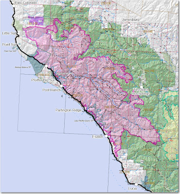
South Side:
It is largely symbolic at this point, but the Basin fire has bumped up against the Indians fire. The fires met about a mile north of the fire line on the Rodeo Flats trail.
I am hearing that the fire burned intensely late yesterday near the remaining open line on the Rodeo Flats trail, just south of where the two fires met. There is a chance that the fire burned across the line and progressed 2 miles south almost to the Cook Springs campground near the Carrizo trail, but this is not confirmed. If this is true, it is going to significantly delay the containment of the fire on the south side. But there are secondary lines in this area that the firefighters can fall back to.
North side:
The fire did not spread a great deal on the north side with the exception of the firing the crews are accomplishing along the dozer line. Working to the east, they progressed about a mile past Devils Peak, getting into even rougher, more remote terrain.
East side:
There was no major fire movement on the east side, except for areas near Tassajara. The fire is approaching the road to Tassajara 1.6 miles north of the facility at Wildcat campground. It is also still spreading a mile to the west, and 1.4 miles to the south at Willow Springs campground.
The folks at Tassajara decided to evacuate yesterday, and it's probably a good thing. At best, it will be extremely smoky there for a while... maybe a long while. At the worst, well, we don't want to think about that right now.
East side update, July 10 @ 10:45 PT:
We received a call today from a Wildfire Today reader who said that 5 of the Tassajara folks are still there. We confirmed this on their web site. Apparently as the entire group of 19 drove out, they encountered a check point and were told that if they left, they would not be able to return, so five of them went back to Tassajara.
Someone who posted on Wildlandfire.com's Hotlist Forum said:
In listening to scanner traffic the people at The Zen Center off Tassajara Road decided to leave as the fire approached from the north and west. This is presenting a problem for the crews on scene as the fire has become very established in the Church Creek Area. The East Basin (Air Attack) Diverted all the (air tankers) to this area to try to buy time for them to evacuate by vehicle. Fire has spotted half mile ahead presenting more problems. They have 2 MAFFS ships enroute also.If the report from the forum is true, it sounds like they waited too long to evacuate, and all of the air tankers on the fire had to be diverted from their missions to cool the fire down near the road enough to allow them to drive through the fire area. I hope the remaining five will be OK at Tassajara. And I hope that the firefighters that had been using the air tankers didn't have problems when they lost them to protect the people driving out on the road.
Thanks, caller, for the update.
Big Sur side:
The mandatory evacuation for the Big Sur valley has been lifted and a few businesses are beginning to open for the locals and firefighters. The valley is still only open to residents, but the agencies are re-evaluating the closure and there is hope that the public will be allowed into the area around the first of next week, but that decision has not yet been made. This is a real hardship on the businesses, who rely on the summer season for the majority of their income.
The firefighters:
The next 5-6 miles of the open line on the north side, firing from the dozer line, is going to be exceedingly difficult, tactically and logistically. The task these firefighters have been doing, and especially what they have done recently and will be doing over the next several days, is as difficult as it gets. It is very steep, remote, heavily vegetated country, loaded with poison oak.
I was on the El Cariso Hot Shots when we fought fire in the Big Sur area on the Molera fire in 1972. That memory is seared into my brain as one of the most challenging assignments I have ever experienced as a firefighter. We need to appreciate the work these crews are doing, and we need to find ways to thank them. They are putting out our fires as we sit comfortably at home in front of our computers.
Fire information:
The Los Padres National Forest has stopped putting fire updates on their web page, shrewdly deciding to put all of their eggs into the InciWeb basket. For a week or so, InciWeb was not able to handle the capacity and was out of service, then it worked for a couple of days, and this morning it is out again. Maybe it is just a temporary outage, but for now, there is no official fire information available on the Internet. Again.
The map below shows heat, in red, orange, and black, detected by satellites at about 1 a.m. on Wednesday, with the red areas being the most recently burned. The yellow lines are the latest perimeters uploaded by the incident management teams. Click on the map to see a larger version.

The map below was current at 5:00 p.m. on Wednesday.


No comments:
Post a Comment