Wildfire Today received a call from a local resident who used our "Call Me" button. He said the fire crossed the West Branch of the Feather River (which runs north and south in this area) but the spots across the river were picked up by aircraft and firefighters. He said the fire is being pushed to the south now by a steady 15 mph wind, which would mean it will be moving parallel with the river.
The weather forecast for today:
Paradise (at the fire, elevation 1,715')
Temp: 104
Winds: NE shifting to NW 5-7
RH: 12%
Oroville (12 miles south of the fire, elevation 190')
Temp: 107
Winds: N shifting to W and then NW 7-9
RH: 10%
=========================
The Camp fire, part of the BTU (or Butte) Lightning Complex, slowed last night after burning approximately 50 homes in Concow, California yesterday. Evacuations are in effect for portions of Concow and Paradise displacing an estimated
Monday night between 8 and 10 p.m., firefighters began a firing operation out ahead of the fire, between the fire and Concow. CalFire-Butte County Capt. Scott McLean said the firing was going well, until an unexpected change in the weather occurred after midnight. Strong down canyon winds and a drop in the relative humidity from 43% to 21% caused spot fires far ahead of the firing operation.
McLean said:
We had to try something; the fire was going to get there anyway.On Tuesday the fire reached Concow and burned at least 50 homes. We don't fault the firefighters.... we will take the spokesperson at his word, that the fire would have reached Concow anyway. The strong winds Monday night and Tuesday contributed to the extreme fire behavior that caused the fire to burn all the way to the outskirts of Paradise.
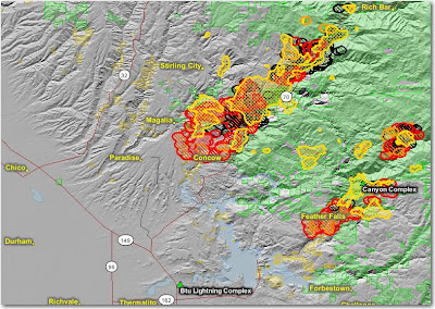
The map below shows heat, in red, orange, and black, detected by satellites last night, with the red areas being the most recently burned. The yellow lines are the latest perimeters uploaded by the incident management teams. Click on the map to see a larger version.


No comments:
Post a Comment