An update from the incident management team at 9:00 p.m. yesterday included this information:
Fire fighting efforts are focused on the north and east ends of the fire today. Hand crews on the west end of the drainage are working onto the north and south sides constructing line and flanking the fire along the ridge tops. Heavy timber, steep, rocky terrain and limited access from roads and water sources remain challenges to fire fighting efforts. An additional 12 loads of retardant (28,000 gallons) from heavy airtankers and 30,000 gallons of water from helicopters were applied to the northeast end of the fire along the ridge near Red Lodge Mountain Resort to keep the fire from spreading further east.A local resident and his family were hiking in the area and had their route cut off by the fire. With the help of some Forest Service trail workers, Don Larsen and his three children hiked 10 miles to safety, but their car is still marooned at the trail head.
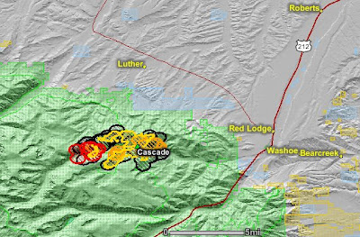
The updated satellite map from last night shows the fire being most recently active on the west side. The map shows heat, in red, orange, and black, detected by satellites, with the red areas being the most recently burned. The yellow lines are the latest perimeters uploaded by the incident management teams. Click on the map to see a larger version.


No comments:
Post a Comment