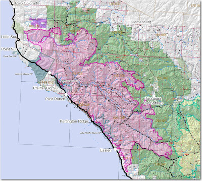
Crews are firing the line downhill along the Rodeo Flats trail toward the Indians fire. This has been going very slowly for the last several days, but I expect they will have to complete this firing in the next day or two. Of course the Indians fire has been relatively cold for a while now, so the act of merging will have no effect on fire behavior, other than the Indians burned area serving as a barrier to the Basin fire.
South side-
The burning operation down Dolan Ridge to the coast highway is complete
North side-
The firing along the Old Coast Road is complete, and the firing on Mescal Ridge has progressed east beyond Bottchers Gap. The fire is burning intensely east of Bottchers Gap, and in the Pat Springs, Little Pines, and Uncle Sam Mountain areas. It is within a mile of the dozer line north of Little Pines, east of Devils Peak. The dozer line is downhill from the existing fire edge, so it will be burning more slowly as it approaches the line, but I imagine the firefighters have plans to fire this out in the near future. There are plans for an additional secondary dozer line north of the existing one east of Devis Peak, but hopefully it won't have to be used.
East side-
The fire is burning intensely:
- west of the Carmel River drainage south of Uncle Sam Mountain,
- in two areas 1.5 to 2 miles northwest and southwest of Tassajara,
- and a large area west of the Indians fire north of the Rodeo Flats Trail.
The map was current as of 1900 Tuesday night. Click on it to see a larger version.


No comments:
Post a Comment