Information about the evacuation of part of Paradise can be found HERE.
According to the Geographic Area Coordination Center, an evacuation of Concow is ongoing, affecting 300 homes and 800-1,000 residents. The local media is reporting that at 8 a.m. this morning extreme fire behavior caused fire crews to be pulled off the fire line, due, in part, to 30 mph northeast winds.
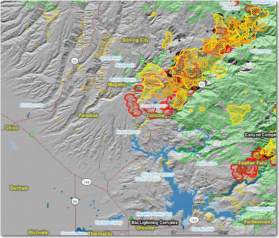
Below is a map that was updated this afternoon. It shows heat, in red, orange, and black, detected by satellites, with the red areas being the most recently burned. The yellow lines are the latest perimeters uploaded by the incident management teams. Click on the map to see a larger version.


No comments:
Post a Comment