.

Monday, June 30, 2008

California: Piute fire from space


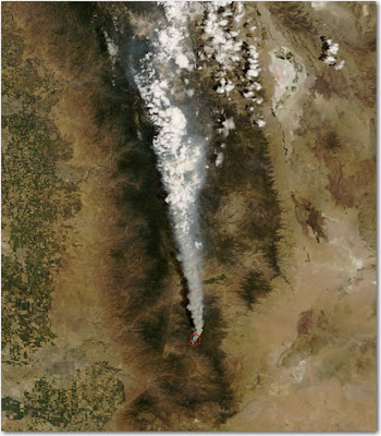
Here is a satellite photo of the Piute on the Sequoia National Forest fire taken about 2 p.m. PT Monday. The red area at the base of the smoke plume is heat detected by the satellite. Click on the photo to see a larger version.

HERE is a link to a satellite photo that shows most of California. It's a large file.

California: Piute fire

The Piute fire on the Sequoia NF started yesterday and is moving out. HERE is a link to an almost-live web cam view of the fire.
Piute (CA-SQF-1356) 2,560 acres and 4% contained. Protection of the USFS Repeater Site, the Buston Mill, historic town sites and critical habitat areas are a priority. Closure was ordered for area campgrounds, resulting in the evacuation of campers. Road closures include Piute Mountain Rd., Saddle springs Rd. and Cold Springs Rd. Evacuations were put in place for residences and visitors in Brown's Meadow and French Meadow. An evacuation advisory notice was issued to residents and visitors of the Claraville Town site. An Evacuation Center was opened in Lake Isabella at the VFW/Senior Citizens's Center.

Evacuation definitions

The Basin and Indians fires in Monterey County in California have caused various types of evacuations. Here are the definitions that the county is using:
1. Evacuation Advisory: This is a precautionary notice designed to give residents time to prepare for a possible evacuation. If you have special needs you might want to leave the area until the threat is passed. If you have livestock that needs transporting, you should move them.

2. Voluntary Evacuation: You are strongly urged to leave the area. If you choose to remain, you should be prepared to take action immediately if the danger approaches.

3. Mandatory Evacuation: You are in jeopardy and should leave the area immediately. If you choose to remain, you may be on your own as emergency personnel likely will not be able to help you.

Sunday, June 29, 2008

California: Basin fire update

The Basin fire near Big Sur has been very active today and spread significantly on the northwest side closest to Big Sur as well as on the east side, moving closer to the Indians fire.

A local news article:
The Monterey County Herald
Article Last Updated: 06/29/2008 04:06:28 PM PDT

An evacuation advisory has been issued for the Palo Colorado Canyon area due to the northward spread of the Basin Complex fire Sunday.

The advisory is a precautionary notice warning residents to prepare to leave if necessary.

Basin Fire spokeswoman Tina Rose said Sunday that residents have been moving animals out of the area and many have made arrangements to stay elsewhere. More than 1,000 homes are threatened by the fire, which grew by more than 2,000 acres overnight.

"Most people are taking the advisory as seriously as we want them to," Rose said. "The movement of the fire is to the north, east and south."

Emergency broadcast announcements were aired on local radio and television stations Sunday morning.

The affected area includes Garrapatos Road, Redwood Estates, Green Ridge, Rocky Creek Ranch, Long Ridge, Rocky Creek Road and Ray Ridge Road.
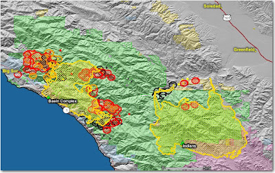
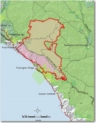
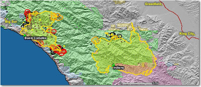
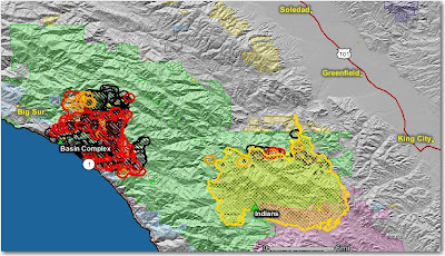
This map shows that the Basin fire is quite a bit closer to Big Sur than it was two days ago. Most of the heat shown on the Indians fire is from their burnout along the Arroyo Seco drainage.

The map below shows heat in red, orange, and black, detected by satellites, with the red areas being the most recently burned. The yellow lines are the perimeters uploaded by the incident management teams. Click on the map to see a larger version.

California: Indians fire and Basin Complex

The firing operation on the Indians fire along the Arroyo Seco drainage is almost complete. Now some of their resources are concentrating on putting in indirect lines out ahead of the Basin Complex, for their purposes, being called Basin Complex East. Dozers have already completed approximately 6 miles (as the crow flies) of line north of the Indians fire, from the Arroyo Seco drainage north along the east boundary of the Los Padres National Forest.

On the south side of the Basin Complex, Hot Shot crews from the Indians fire are constructing hand line on the west side of the Indians fire, and south of the Basin Complex, between the Indians fire and a ridgetop dozer line. A shitload of dozer line has already been completed along that ridge and other ridges south of the Basin Complex. Some of them simply involved improving lines used on the Marble Cone and other fires, 10 to 30 years ago. If they can tie that main ridgetop dozer line off with another dozer line towards the west to the ocean, which they are working on, and then fire and hold these lines (a big if) they could hem in the south side of the Basin Complex.

Hot Shot crews and dozers from the Basin Complex West are working south of the fire putting in line from the North Coast Ridge Road to Rock Slide Peak.

I used old fashioned tools called "pens" to create this very sophisticated map to illustrate the above. Click on it to see a larger version.


Photo, Pam Balazer, USFS
Map, Bill Gabbert

Martin Mars lands at Lake Shasta

The third time proved to be the charm for the Canada-based Martin Mars air tanker. After having engine problems on Friday and Saturday, it successfully completed it's 4-hour trip to Lake Shasta north of Redding, California this morning. It will stage there until it receives an assignment, which will likely occur today, visibility permitting. On each mission it can drop 7,200 gallons of water, Thermogel, or water mixed with foam concentrate on a fire and then will refill it's tank by scooping water from a lake.

Wildfire Today covered the saga of this aircraft earlier, here and here.

The Martin Mars anchored on Lake Shasta, June 29. It has already been outfitted with an American flag and a USFS decal. Click on the photo to see a larger version. Photo courtesy of ShastaLake.com.

Incident Management Teams committed

The National Situation Report shows that 16 Type 1 Incident Management Teams and 3 National Incident Management Organization (NIMO) Teams are assigned. The national IMTeam rotation page, which apparently has not been updated in a while, lists 17 Type 1 Teams, with one of those shown as "unavailable". So apparently, all of the Type 1 Teams that are available are committed to fires.

There are 3 or 4 NIMO Teams. The status of the brand new Phoenix and Portland Teams is unclear, but one of them must be operational in addition to the previously organized Boise and Atlanta Teams, since a total of 3 are assigned.

I'm scared to link to the regular IMTeam web site, since simply opening the site in your web browser last week installed a virus or trojan on your computer. They claim the problem is fixed now. I am probably being overly cautious, but for a while at least, if I don't have to go there, I won't. The NIMO site and the IMTeam rotation pages are on different systems and did not have a virus problem.

Update on fires on the Shasta-Trinity NF

From the U.S. Forest Service, Shasta-T. fires only, updated at 8 p.m., June 28:
Lime Complex Incident Command Post is at Hayfork, CA. Evacuations are in effect for the Platina area due to the Noble Fire, and in Wildwood due to the Telephone Fire. This complex includes about 79 fires ranging from small spots to fires over 9,000 acres. Hyampom continues to be threatened by fires. The Yolla Bolly Wilderness is closed.

Iron Complex Incident Command Post is at Junction City , CA . The Canyon Creek area and Helena remain under an evacuation order due to activity on the Eagle Fire. Slattery Pond is still under a voluntary evacuation. The Iron Complex is now managing 21 fires with some over 7,000 acres. The Ironsides and Don Juan fires have grown together.

Alps Complex - Fifteen fires (formerly part of Iron Complex) totaling 2,445 acres are assigned to a new Management Team. Most fires are in the Trinity Alps Wilderness Area. The Buckhorn Fire has backed down to a dozer line at the private Brooks Ranch.

Mars Martin air tanker: more problems

The 61-year old amphibious air tanker on contract from a Canadian firm had still more mechanical problems on it's second attempt to make the 4-hour flight to Lake Shasta near Redding, California. On Friday it was 10 minutes from landing on the lake when it lost an engine and returned to their base in British Columbia. After making repairs, it took off again on Saturday, but the engine did not feel right to the pilots, so they returned to their base again. The owners of the plane expect to try again on Sunday, June 29, to fly it to Lake Shasta.

On Saturday there were so many spectators at Shasta Dam watching fires in the area and hoping to see the air tanker land on the lake that authorities had to close the loop road to the dam for safety.

The owner of the aircraft, Coulson Flying Tankers, has a second Martin Mars, but it is out of service at their base in British Columbia.

While we're waiting for the ship to show up in California, here is a little air tanker porn for you. Or if you prefer, air tanker eye candy. You have to admit, it's a very nice looking aircraft. I hope they can get the mechanical problems sorted out.

File photo, courtesy of Coulson Flying Tankers

Boy injured by bison

On Friday, a Pennsylvania family in Yellowstone National Park was shrewdly standing right next to a mature bull bison, posing for pictures, when the bison, having had enough of that crap, flipped a 12-year-old boy 10 feet into the air. Witnesses said the boy was within 1-2 feet of the bison despite repeated warnings from other visitors.

The boy was not gored by the bison's horns, but had some abrasions caused by hitting the ground following his airborne adventure. Since he complained of abdominal pain, he was flown to a medical center in Idaho Falls.

This becomes the third time Wildfire Today has used the word "idiot" as a label for a post.

More dry lightning for northern California

From the Weather Service-- issued at 5:32 a.m. PDT June 29:
RED FLAG WARNING FOR DRY LIGHTNING THROUGH 11 PM TONIGHT FOR THE MOUNTAINS OF EASTERN SHASTA COUNTY ...THE BURNEY BASIN ...AND FOR THE NORTHERN SIERRA NEVADA MOUNTAINS NORTH OF I-80.
One of these days the Weather Service is going to un-stick their caps-lock keys.

U.S. Forest Service's "Key Messages"

The U. S. Forest Service in California is aggressively trying to get certain messages out about the fire situation in northern California by issuing a laundry list containing 10 "Key Messages". They took the extraordinary step of having them inserted into the Northern California Geographic Area Coordination Center's "News and Notes", which usually contains just the bare facts and numbers about initial attacks and ongoing fires.

This may be in response to allegations by some that the USFS is losing many key firefighters to agencies that have much better pay and benefits packages, leaving the agency in California with too many unfilled positions and unstaffed engines. Here are some samples of the USFS "Key Messages":

KM1: The Forest Service has over 4,000 firefighters stationed and available in California. They are engaged in aggressive firefighting efforts throughout the state.

KM2: The Forest Service can mobilize resources from other regions and states. We are ordering additional resources with support nationwide. We have even received international assistance from Canada with the Martin Mars aircraft.

(note from Wildfire Today: Wildfire Today reported on the Martin Mars air tanker here. It's not exactly "international assistance from Canada". The USFS recently signed it up under contract, just like any other contract resource. On both Friday and Saturday, the 61-year old ship made aborted attempts to fly down from British Columbia but had engine problems before landing on Lake Shasta and returned to Canada using just 3 engines. They will try a third time on Sunday. A Canadian infrared aircraft is also on contract and is being used in northern California, along with the two USFS infrared ships, and UAV's from NASA, the Air Force, and the Navy.)

KM5: Every Modular Airborne Fire Fighting System (MAFFS) available in the country is currently in California. MAFFS are able to drop up to 3,000 gallons of water.

("water"? The MAFFS drop long-term fire retardant. There are 6 MAFFS's working, based out of McClellan. Last year there were approximately 16 large airtankers under federal contracts. This compares to 45+ during the "Siege of '87", another huge lightning bust in northern California.)


KM7: We recognize changing conditions and adjust by moving resources accordingly. For example, we may redirect people from one fire to help with another fire. By making progress on the Indians Fire, we were able to send those resources to the Basin Fire, (both on the Los Padres NF) ensuring of course that the firefighters get plenty of rest.

KM8: We are constantly moving, mobilizing and making adjustments on our resources. This is a standard operating procedure. We have been fighting fires successfully for over 100 years. This is what we do best.

(KM7 and KM8 are duplicates. "Moving resources" has been Under Secretary of Agriculture Mark Rey's answer to the allegations of a lack of adequate resources due to retention problems within the USFS in California.)

KM9: Fuels are extremely dry and research has documented strong links between past climate variability and area burned in wildfires, particularly in the western United States. Projections from climate models suggest that burned areas and fire severity will increase in the future over much of the United States. These changes will affect fire suppression costs and resources, alter ecosystem characteristics, and increase potential fire risk to communities. (*See further approved Climate Change talking points at http://www.fs.fed.us/research/fsgc/briefing-papers/3-CC-FS-and-Fire.pdf

(In other words, "It's not our fault.")

California: Basin and Indians fires map and update

Indians fire
The crews made a lot of progress in the last 24 hours firing along the Arroyo Seco drainage. There was very little activity from the main fire. There is still the possibility that the Basin complex will burn into the Indians fire. A "zone" boundary line has been established between the two fires to clarify responsibilities. The Indians fire is 60,070 acres and 82% contained.

Basin Complex (Gallery and Basin fires)

The fire was very active on the northwest side. They have 16 dozers and 23 crews building line, with some of the lines being in the same places as on the 1977 Marble Cone and 1999 Kirk fires. Highway 1 is still closed to non-residents and evacuations are in place.

The map below shows heat, in red, orange, and black, detected by satellites last night, with the red areas being the most recently burned. The yellow lines are the perimeters uploaded by the incident management teams yesterday. Click on the map to see a larger version.

Saturday, June 28, 2008

Smoke from California fires

The residents and firefighters in northern California must be hating the air they have been forced to breathe for the past several days. I got a taste of it a while ago here in South Dakota. I smelled forest fire smoke and looked outside and saw that smoke is visible in the air. I checked the current satellite photos and there were no large fires or smoke plumes originating anywhere near the Black Hills.

The new NOAA smoke tracking site has been down for the last 1-2 weeks, but I thought I'd check it on the off-chance it has been fixed. I was pleasantly surprised to see that it is working! And now I know why I'm smelling and seeing smoke.

Click on the map to see a larger version.

Map of Basin and Indians fires

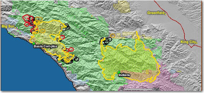
Here is a map of the Indians fire, west of King City, and the Basin Complex (Gallery and Basin fires) south of Big Sur.

The red area on the northwest side of the Indians fire is most likely their firing operation along the Arroyo Seco river.

The map below shows heat, in red, orange, and black, detected by satellites last night, with the red areas being the most recently burned. The yellow lines are the perimeters uploaded by the incident management teams yesterday. Click on the map to see a larger version.


Basin complex update from the U.S. Forest Service last evening:
Firefighters continue to build and improve fireline throughout the east side of the Big Sur area and have been moving toward Manuel Peak. Dozer lines are being constructed along the North Coast Ridge Road south to Dolan Ridge to eventually meet up with the road from the Big Creek State Reserve. Structure protection engines remain in place along Partington Ridge, the North Coast Ridge Road and Highway 1. Today higher humidity at all elevations within the fire has moderated fire behavior due to wind changes.
Indians fire update from the U.S. Forest Service last evening:
The fire did not expand significantly today. The firing operation continued eastward from the Arroyo Seco Campground south of the Arroyo Seco River and good progress was made due to the absence of smoke shading from the Basin Complex Fire and warmer, dryer weather. Good progress was made today improving line along the Rodeo Flats Trail.

Photo of Basin complex courtesy of Alana Cain

Martin Mars expected at Lake Shasta, California

A Martin Mars water-scooping amphibious air tanker lost an engine yesterday 10 minutes before it was due to land at Lake Shasta in northern California to help with the forest fires. It turned around and flew back to it's base at Port Alberni, British Columbia where the engine was going to be repaired or replaced. If the repairs go well, their plan is to land the plane at Lake Shasta at 10 a.m. today, Saturday. But as this is being updated at 7:45 a.m. PT, the aircraft, Canadian number CFLYL, is not showing up on flight tracking.

The aircraft can carry 7,200 gallons of water, Thermogel, or water with a 0.4% solution of foam concentrate. It may be the only air tanker with Thermogel capability. The ship was used for a while last fall in southern California during their fire bust and flew out of Lake Elsinore. This year it will be under contract with the U.S. Forest Service.

File photo courtesy of Coulson Flying Tankers

Friday, June 27, 2008

Say "Thank you" to firefighters

"Silas" left this message on one of the earlier posts:
I'm the editor of the Record Searchlight in Redding, and we have posted a page for our community to thank the firefighters for their efforts. Anything you can do to spread the word to your readers would be appreciated. There's a lot of gratitude here, and we want to make sure the folks who should hear about it do.
Take a couple of minutes and say thanks. Here's the link:

http://www.redding.com/news/2008/jun/26/thank-you-firefighters/

Map of California fires

HERE is a link to a pretty good map that shows some of the larger fires in California and includes a little information about each one.

Infrared missions

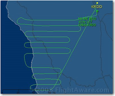
As we reported earlier, there are quite a few aerial assets collecting infrared imagery of the fires in California. Infrared interpreters take the data from the aircraft, interpret it, then display it on maps for the incident management teams.

One of the aircraft is a twin-engine Piper Navajo that belongs to the Canadian contractor Range and Bearing, Inc. I did a little research and found out what they did this evening.

They took off from Redding, California (KRDD) and flew southeast about 50 miles. The parallel flight lines appear to be in the area of the BTU Lightning Complex and the Canyon complex. Then they landed at Redding and took off right away and flew northeast about 15 miles. They flew two circles in the area of a fire near Ingot then returned to Redding.

The map below shows the track of N144Z, the US Forest Service Citation, a jet, flying from Redding, to the Basin Complex and Indian fires (close to each other near Big Sur), then northeast to the area of the Oliver Complex fire southwest of Wawona. Then they headed northwest at 366 knots to some other fires southwest of Redding, then landed at Redding. They most likely dropped off the imagery, refueled, and departed again to fly other fires.


The last map, below, shows the track of N149Z, a twin turboprop King Air 200 that belongs to the U.S. Forest Service. It spent quite a lot of time southwest of Redding flying fires in the Ukiah area between highways 1 and 101, and then north to the Mendocino National Forest. Their flight plans called for them to land at Redding then depart for another 4-hour mission.


Maps, courtesy of flightaware.com

CA: Basin map

Here is a map that was updated today of the Basin fire (formerly known as the Gallery fire) south of Big Sur. Click on it to see a larger version.

National fire situation

Six MAFFS C-130 air tankers from the military have now been activated and are based at McClellan airport in Sacramento, CA and at Chico, CA. They are from Charlotte, NC, Colorado Springs, CO, and Cheyenne, WY.

The National Preparedness Level is now 4. This level can be authorized when:
Three or more Geographic Areas are experiencing incidents requiring Type 1 and 2 IMTs. Competition exists between Geographic Areas. Nationally, 60 percent of Type 1 and 2 IMTs and crews are committed.
Weather forecast for northern California

FIRE WEATHER WATCH
NATIONAL WEATHER SERVICE SACRAMENTO CA
948 AM PDT FRI JUN 27 2008

...FIRE WEATHER WATCH FOR DRY LIGHTNING FOR THE INTERIOR MOUNTAINS INCLUDING THE SIERRA NEVADA FOOTHILLS FROM FRIDAY EVENING THROUGH LATE SUNDAY NIGHT..

.HIGH PRESSURE OVER THE DESERT SOUTHWEST IS FORECAST TO BUILD NORTHWARD ACROSS THE GREAT BASIN AND INTO NORTHERN CALIFORNIA FRIDAY AND SATURDAY. THIS WILL CAUSE SUBTROPICAL MOISTURE FROM THE DESERT SOUTHWEST TO SPREAD NORTHWARD OVER THE SIERRA NEVADA ON FRIDAY...AND OVER THE COASTAL RANGE AND NORTHERN MOUNTAINS OF SHASTA COUNTY FRIDAY NIGHT AND SATURDAY. THIS MOIST AND UNSTABLE AIR WILL RESULT IN SCATTERED THUNDERSTORMS OVER THE HIGHER TERRAIN. THE THUNDERSTORMS WILL LIKELY HAVE LITTLE PRECIPITATION ASSOCIATED WITH THEM FRIDAY NIGHT AND SATURDAY. LOW PRESSURE MOVING NORTHWARD ALONG THE CALIFORNIA COAST WILL CONTINUE THE CHANCES OF THUNDERSTORMS ON SUNDAY...WITH STORMS GRADUALLY BECOMING WETTER.


Infrared Aircraft

Both of the U.S. Forest Service infrared line-scanning fixed wing aircraft are working the fires in California and flying out of Redding.

The Ikhana Predator B Unmanned Aerial Vehicle operated by NASA has been ordered and will begin flying fires next week, using it's equipment to take infrared imagery of the fires and downlink it in real time. Last year it flew missions over fires lasting from 10 to 20 hours before landing.

Update, 11:12 pm, June 27. The Ikhana will fly test flights over the Clover fire on June 28. Their first actual mission will occur July 1 when it will collect imagery over at least 10-12 fires in central and northern California.

Navy and Air Force Global Hawks as well as a U2 airframe will be flying training missions over California on Friday and Saturday.

Fire Summary (Five Day Trend)


Date

Mon

Tue

Wed

Thu

Fri

Day

6/23

6/24

6/25

6/26

6/27

Initial Attack Fires

517

312

406

283

226

New Large Fires

25

14

12

10

6

Large Fires Contained

6

3

8

4

7

Uncontained Large Fires

37

48

52

53

56


The above 5-day summary courtesy of the NPS Morning Report

California: Gallery, Basin, Indians fires

Smoke from the Gallery/Basin Fire floats over the coastline.
Photo credit: Pam Balazer, USFS

Basin Complex

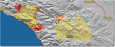
On the Los Padres National Forest south of Big Sur, the Gallery and Basin Fires have officially burned together now. On Thursday the fire continued to burn actively at the higher elevations, exhibiting extreme fire behavior. It continues to back down towards portions of Highway 1, to move south into the South Fork of the Big Sur River drainage, and north towards Manuel Peak. It is 20,763 acres and 3% contained.

Indians fire
Without the smoke from the Basin Complex shading the area, firing operations on the northwest side were initiated with better success on Thursday. It is 59,066 acres and 71% contained.

The map below shows heat, in red, orange, and black, detected by satellites, with the red areas being the most recently burned. The yellow lines are the perimeters uploaded by the incident management teams. Click on the map to see a larger version.


Thursday, June 26, 2008

Smokerjumper activity in northern California

The smokejumpers have been busy.

As of 6/25 119 Jumpers Committed to these National Forests in CA:
20 Sierra
30 Shasta Trinity
42 Mendocino
10 Klamath
10 Plumas
7 Six Rivers

Boosters (out-of-area) From:
30 Redmond, OR
30 Missoula, MT
23 McCall, ID
12 Grangeville, ID
9 North Cascades-Winthrop, WA

Total of 104 Boosters
RDD jumpers 38

YTD
31 Fires
182 Jumps

Since June 20
30 Fires
177 Jumps

Weather forecast for northern California

Smoke will be another issue this morning, limiting the daytime heating and surface winds during the afternoon hours. However, later this evening and tonight winds will pick up across the far Northern Sacramento Valley and adjacent foothills. These winds will be from the N to NE at 10-20 mph across many exposed areas, along with poor nighttime humidity recovery.

Some areas in the Feather Drainages could see gusts over 35 mph late tonight thru Friday morning. Afterwards, by Friday afternoon all eyes will be on the next thunderstorm outbreak, moving in from the Sierra and shifting NW into much of Northern California through the weekend. Many of these storms could be dry.

(the above, and some of the information below, is from North Ops Predictive Services, 1900, June 25)

What this means for fire behavior-
Since Sunday June 22 the stable atmosphere has not only produced inversions that trapped smoke, but it also slowed down fire behavior due to the resistance to vertical motion and shading from the smoke. When this begins to change Thursday afternoon and Friday there could be a gradual change in venting, and an increase in fire behavior. But in some situations, a major change in rates of spread could occur in as little as 1-2 hours.

What this means for firefighters-
Smoke will lift earlier in the day allowing more options for air operations, and surface winds could become stronger. EXPECT changes in fire behavior. Have lookouts observe changes winds, visibility, and smoke behavior, such as gentle lifting changing to more rapid rising of smoke and faster growing columns.

Californnia lightning fires

Smoke grounds air tankers
Yesterday heavy smoke from the 40,000 acres burning near the north end of the Sacramento Valley kept air tankers on the ground.

Govenator: just say NO to fireworks
California Governor Arnold Schwarzenner asked residents not to buy fireworks this 4th of July. I'm with him on that. I have put out too many fireworks-caused fires. From Arnold:

"I know that the people that are selling all this stuff are going to go crazy now when I say this, but don't buy any of the fireworks," said Schwarzenegger, surrounded by dozens of firefighters, Monterey County law enforcement representatives and elected officials. "Don't go out and do fireworks this year ... . It's just too dry and too dangerous to do those things."

The governor spoke at the Basin Complex Fires incident command post at Andrew Molera State Park off Highway 1.

Courtesy of thecalifornian.com

Concow evacuated
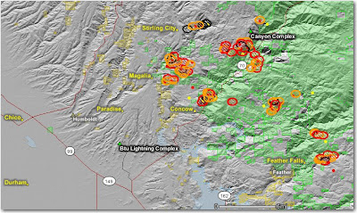
Most of the community of Concow, east of Chico, is evacuated due to the Empire and Rim fires, part of the BTU Lightning complex which closed Hwy 70. The Empire and Rim fires will most likely burn together.

According to NCOCC: Fires in this complex are immediately threatening communities. The air was stable last night, so fire activity was minimized. The inversion layer still dominates the incident area. If the inversion layer lifts, fire intensity will greatly increase, causing additional evacuations and significant fire spread. Some of the fires are in remote areas making containment difficult and will require large numbers of hand crews.

The map below shows heat, in red, orange, and black, detected by satellites, with the red areas being the most recently burned. The yellow lines are the perimeters uploaded by the incident management teams. Click on the map to see a larger version.


InciWeb still broken
The InciWeb site, which should be the best place to go to get information about fires, is least likely to be working during multiple fire conditions due to very limited capacity. Not only is it frequently impossible for citizens to visit the site, but the fire managers are unable to upload critical information. The federal and state agencies that maintain this site need to install better servers.

Indians fire
The fire was relatively quiet yesterday due to higher humidities and shading from the smoke of the nearby Basin fire. The Team ordered evacuations in the Arroyo Seco area on the north side because of planned burnout operations, but the burn was limited due to weather conditions. It is 58,872 acres and 71% contained. (see the map below)


Basin Complex, Gallery fire
The Partington Ridge area has been evacuated. The fire is moving south into the South Fork of the Big Sur River drainage and north towards Manual Peak. The Basin and Gallery fires are within 1/2 mile of each other and are expected to merge soon. Highway 1 is still closed to non-residents. The complex is 20,600 acres and 3% contained. (see the map above)

Wednesday, June 25, 2008

California firefighter loses home while fighting another fire

From insidebayarea.com:
By Ben Aguirre Jr.
The Argus

FREMONT — One of Fremont's firefighters lost his Santa Cruz County home to a wildfire last weekend as he was battling another blaze in Monterey County, fire officials said.

Richard Simon, a 25-year veteran of the fire department, was fighting fires in King City when he got word of the Trabing Fire, which started Friday afternoon and destroyed 630 acres and several homes, including Simon's, near Highway 1 north of Watsonville, said Fremont Fire Division Chief Geoff LaTendresse

Simon's family, including his wife and sons, were home at the time, but they escaped unharmed.

Fremont Fire Capt. Gerry Fogel said the family was able to round up most of the livestock, including horses, but the family lost three goats during the fire on their 3-acre property.

"It just shows that it can happen to anyone, even us," Fogel said.

Simon has fire insurance. He and his family are staying with a friend for the time being, the officials said.

Firefighters have held an internal fundraiser and a clothing drive for the family, but no public fundraising efforts have been organized, the officials said.

Map of Northern California fires

HERE is a link to a very nice map that shows many of the fires in northern California. Updated at noon today, June 25.

Honor the Dude Fire victims

Tomorrow, June 26, pause for a moment to honor the memory of the six firefighters that perished on the Dude fire, June 26, 1990 in Walk More Canyon on the Tonto National Forest north of Payson, Arizona.

Send Barack Your Baby

There is a hilarious web site, SendBarackYourBaby.com that you will find useful if you'd like Obama to kiss your baby but find it too inconvenient to go to a rally and stand in line. The concept is, you ship your baby to Obama, being sure to complete the "Baby's Packing Slip", he kisses it according to your instructions (Kiss, Hug, Give Hope, or Other ___), then ships the baby back to you.

Be sure and check out the Shipping Instructions and the Frequently Asked Questions pages. For example:
How will you return my baby?
Most babies are back home within 14 business days. We send them via insured UPS Ground in a specially designed box, and to avoid mixups, we require that somebody sign for the delivery. Shipping to addresses outside the continental United States can take up to two additional weeks.

Incident logbooks

I recently learned about a new company, InciDocs Publications, that is producing logbooks for Incident Command System positions. They are all 5.5" x 8.5" and fit into the cargo pocket of your Nomex pants.

All versions have sections for travel information, in-briefing notes, contacts, web sites, ICS-214 Unit Logs, and a fillable calendar. They have a heavy-duty front and back cover and holders for business cards and receipts.

Logbooks are then customized to distinct ICS positions by inserting a 14-day daily log section that collects information specific to that job function. They can even be further customized by printing the graphic of your agency or incident management team on the cover. They have dozens of logos on file already.

From the web site:
Carrie Dennett, owner of InciDocs Publications, spent 13 years in fire and resource management for the National Park Service. She was the Fire Management Officer for two national parks for the last 6 years and a Fire Ecologist for the previous 7 years at three national parks in Arizona. Though retired from the National Park Service, Carrie still holds a position on a federal type 1 incident management team as a Situation Unit Leader and has responded to many wildland fires and hurricanes with type 1 and 2 teams in the last 7 years.

Thanks, Dean, for the tip.

Fire captain and 15 inmate firefighters injured in crew carrier crash

From the Press-Enterprise:
10:00 PM PDT on Tuesday, June 24, 2008
By JOHN ASBURY
The Press-Enterprise

A bus filled with Riverside County firefighter inmates toppled in Aguanga on Monday night, injuring all 16 on board, according to the California Highway Patrol.

The Riverside County Fire Department bus was leaving the scene of a 20-acre blaze about 7:30 p.m. near Highway 371 and Wilson Valley Road. The Oak Glen Conservation Fire Camp inmate crew was brought in during cleanup efforts to assist firefighters, Riverside County fire officials said.

The driver, fire Capt. Steve Knutson, was headed west on Wilson Valley Road when he began driving down a speed grade, CHP Officer Ron Thatcher said.

He was going too fast and tried unsuccessfully to shift gears, Thatcher said. The bus ran up a dirt embankment and flipped on its right side.

The fire captain suffered moderate injuries and was taken by ambulance to Inland Valley Medical Center in Wildomar, Thatcher said.

Two inmates were critically injured and one was airlifted to Riverside County Regional Medical Center in Moreno Valley.

Another inmate was reported with moderate injuries and 12 other inmates who suffered minor injuries were treated at the scene, according to the Riverside County Fire Department.

Summary of national statistics

The National Park Service's "Morning Report" has always had an elegantly simple way of summarizing the current national fire statistics. Unfortunately, they do not report on the weekends, when it would have shown much higher numbers of initial attack fires when the 900+ new fires in California would have been counted. Most of the recent lightning-caused fires in California started Friday night and Saturday. ("large" fires are greater than 100 acres)

Fire Summary (Five Day Trend)

Date

Thu

Fri

Mon

Tue

Wed

Day

6/19

6/20

6/23

6/24

6/25

Initial Attack Fires

202

265

517

312

406

New Large Fires

5

9

25

14

12

Large Fires Contained

0

6

6

3

8

Uncontained Large Fires

14

16

37

48

52


National Resource Commitments (Five Day Trend)

Date

Thu

Fri

Mon

Tue

Wed

Day

6/19

6/20

6/23

6/24

6/25

Area Command Teams

0

0

1

1

1

NIMO Teams

1

1

2

3

3

Type 1 Teams

1

1

8

8

12

Type 2 Teams

5

6

11

12

15

FUM Teams

1

1

0

1

0


Weather forecast
... is for more lightning, starting out dry, for northern California beginning Friday and lasting for several days. The thunderstorms will have a greater chance of having a little moisture on Saturday.

MAFFS..... Four C-130 air tankers operated by the military have been ordered for the fires in California. They are coming from Charlotte, NC and Colorado Springs, CO and should be operational today.
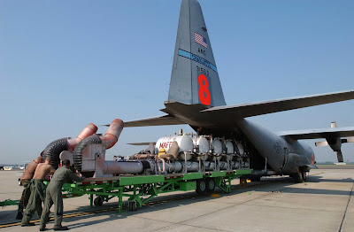
Airmen from the North Carolina Air National Guard's 145th Airlift Wing push a modular airborne fire fighting system onto a C-130 Hercules. The system is a series of pressurized tanks that hold 3,000 gallons of flame-retardant liquid. (U.S. Air National Guard photo/Tech. Sgt. Brian E. Christiansen) Click on the photo to see a larger version.


The Unable to Fill list for northern California has 35 Incident Command System job categories that they can't fill.

The California Wildfire Coordinating Group has raised the Preparedness Level to five, the criteria for which is:
CALMAC is fully activated. Multiple large fires are common in the north and or the south. Fire danger is very high to extreme. Resources are being mobilized through the National Coordination Center. Activation of National Guard or military done or under consideration.

California: Clover fire

The Clover fire, on the Sequoia and Inyo National Forests listed at 13,250 acres and 10% containment, has been less active the last two days.

Photo from the Clover fire

The map below shows heat in red detected by satellites last night. The perimeter as uploaded by the incident management team is in yellow.

California: Gallery, Basin, Indians fires update

On the north side of the Indians fire an evacuation order has been placed for the Arroyo Seco Drainage effective at 0800 hours on June 25.

The Gallery fire south of Big Sur, part of the Basin complex, has been very active the last few days. If it has not already, it almost certainly will merge with the Basin fire just to the north. As of last night the combined acreage was 13, 550 for the two fires. Evacuations are still in effect for the Partington Ridge area, and Hwy. 1 remains closed. The fire has consumed 16 structures and is burning in the tracks of the 1977 Marble-Cone fire which scorched about 165,000 acres.

You have to think about the possibility of the Basin complex burning into the Indians fire which is about 5-7 miles away. There is a 20-39% probability this will happen by June 30 if there is no suppression action in that area. I imagine that would disappoint Bill Molumby's team that has struggled to obtain 71% containment of the 57,943 acre Indians fire. Having burned area on both sides of your fireline is disconcerting, to say the least.

The map below shows heat in red detected by satellites last night. Click on the map to see a larger version.

Tuesday, June 24, 2008

Summary of Northern Calif. Fires

For the lightning bust, as of noon today, June 24, in Northern California only:

Fires on federal jurisdiction:
Number of fires: 528
Acres burned: 8,347

Fires on state jurisdiction:
Number of fires: 455
Active fires: 101
Unstaffed fires: 73
Contained: 203
Acres burned: 52,346

Not all initial attack fires are reported

Total reported fires during the lightning bust in northern California: 983

Incident Management Teams committed in northern California only, as of 1300 today:

  • SHF - Lime Complex- T-2 Kaage/ T-1 Opiliger
  • SHF - Iron Complex - T-2 Swarztlander
  • SHF - Area Command Zimmerman
  • SHF – FUMT Ourada/Soper
  • LNF - Cub Complex – T-2 Batten
  • LNF – Peterson – T-1 Ruggiero
  • KNF- Siskiyou Complex- T-2 Paul
  • PNF- Canyon Complex - T-1 Pincha -Tulley
  • SRF – Ukonom/Orleans– T-2 Lund
  • SRF - Hells Hat Complex – T-2 Secrest
  • TNF - Yuba River Complex – T-2 Joseph
  • TNF – American River Complex – T-I Summerfelt
  • SHU - SHASTA COMPLEX – T-1 KERCHEN
  • BTU - Butte Complex – T – 1 Lewin
  • MEU - Mendincino Complex – T-1 Waterman
  • LNU - Wild Fire – T-1 Morris
  • ONC- NIMO - Gage
  • ONC – Order 1 T1 team staging Sac.

Lessons Learned Center web site is up again

Wildfire Today reported yesterday that the Lessons Learned Center and the Incident Management Teams web sites had been hacked. They are both back up again according to Paula at the LLC:
We thank you for your patience throughout the weekend, and most of today, while our programmers worked to isolate a weakness within our database code. The weakness was exploited by a global attack, affecting over 510,000 WebPages, not directed at any one website. This code was identified and replaced, increasing our system security.

California Fuels and Fire Behavior Advisory

Issued June 21. Better late than never.
=====

Subject: Low live and dead fuel moistures, along with persistent drought, have created the potential for active to extreme fire behavior in many low to mid-elevation parts of the state.

Discussion: With the exception of the northwest corner of the state, most of California is experiencing drought conditions. Effects of lower than normal live and dead fuel moistures and localized sudden oak death are the focus of this advisory.

Concerns to Firefighters:
• Energy Release Components (ERC) at numerous weather stations in the affected Predictive Service Areas (PSA) are setting record highs; this is an indication of very dry fuels. Expect increased fire intensity and spread rates in these areas. Already this year several burnover situations have occurred. The fuels in these PSA’s are primarily grass and brush. A common denominator of fire behavior on tragedy and near-miss fires: Flare-ups generally occur in deceptively light fuels, such as grass and light brush.
• The combination of persistent drought in the South and record setting low March-May precipitation totals in the North has led to low live and dead fuel moistures. Expect fires to ignite easier and spread faster. During mobile attack in light fuels engine crews have found that it takes more time using additional water to knock down fire under these current conditions.
• Both live and dead fuel moistures are 3-6 weeks ahead of last year’s drying rates. Low 1000 hour fuel moistures have been evidenced by complete consumption on recent fires. Anticipate increased spread rates, spotting, and active nighttime burning. Link to extreme fire behavior video on the Indians fire in the Central Coast Mountains:
http://gacc.nifc.gov/oncc/predictive/fuels_fire-danger/LP_FIRE_BEHAVIOR_08.wmv
• Localized sudden oak death (SOD) has affected a number of oak species in southern California.
Fire behavior in areas affected with SOD is often more intense due to increased fuel loadings.

Mitigation Measures:
• Local and inbound fire personnel need to develop situational awareness of the conditions represented in this advisory. Details on site specific conditions regarding ERC’s, live and dead fuel moistures, and/or disease should be covered during briefings.
• Ensure firefighters have good anchor points, escape routes, and safety zones. Remember LCES.
• Consult the latest Fire Weather Forecasts, Monthly Fire Weather / Fire Danger Outlooks, Pocket Cards, and the recently updated California Fire Season Assessment (July-October) posted at:
http://gacc.nifc.gov/oncc/predictive/index.htm
http://gacc.nifc.gov/oscc/predictive/index.htm

Area of Concern:
The area of concern covers the following 6 PSA’s in California: Bay Area, Central Coast Mountains and Valleys, Mid Coast to Mendocino, Sierra Foothills, Sacramento Valley Foothills and the portion of the Northern Sierras below 3,000 feet elevation. A map showing the areas of concern described in this advisory can be found at:
http://www.nifc.gov/nicc/predictive/fuels_fire-danger/fuels_advisories.htm

Issued: June 21, 2008 Valid Until Further Notice
=========
HERE is a link to the document that includes a map.

(From FireNet)
California: Gallery, Basin, Indians fires

The Gallery fire, part of the Basin complex south of Big Sur, was very active yesterday. The Gallery fire is approximately 5,920 acres and is 10% contained. The Basin fire, which is north of the Gallery fire, is also part of the complex which totals 8,500 acres. However, in looking at the map below, the Basin and Gallery fires have burned very close to each other, perhaps merging in some areas.

Five structures or out buildings may have been damaged in the last 24 hours, according to the Southern California coordination center.

The Indians fire has completed fireline around the south 2/3 of the perimeter. There is still a great deal of open line on the north side. They have completed a lot of indirect dozer line on the north side side of the fire, south of Arroyo Seco Road.

Here is a map, showing heat detected by satellites last night. The red is recently burned areas, while the yellow is the fire perimeter uploaded by the Incident Management Team. Click on the map to see a larger version.

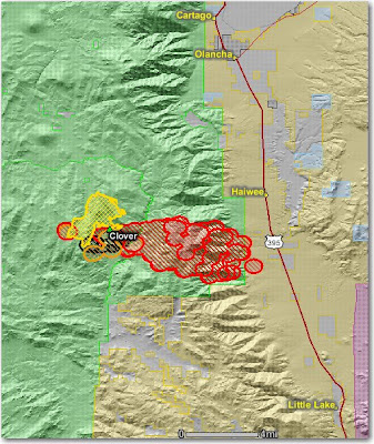
Clover fire map

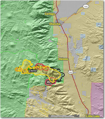
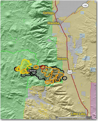
Here is a map of the Clover fire on the Sequoia and now Inyo National Forests in California showing the heat detected by satellites last night in red, orange, and black. The yellow line is the last perimeter uploaded by the incident management team a few days ago. It appears that is was less active yesterday than it was the day before when it made the big run towards Hwy. 395. It has burned 13,049 acres and is 10% contained. A second incident management team has been ordered to manage the portion of the fire on the east side of the Sierra crest.


Monday, June 23, 2008

Clover fire, while still a WFU


I came across a map, above, of the Clover fire on the Sequoia National Forest, while it was still a Wildland Fire Use (WFU) fire on June 18. On the north and west sides, it was mostly hemmed in by previous fires that burned 2-4 years previously. On the east and southeast sides was an old 64-year old burn, and there was no fire history on the southwest side. The black line east of the fire is the Kern River.

Yesterday the fire crossed the Kern River, crested the Sierras, and burned east toward Hwy. 395

Map of Gallery fire near Big Sur

Here is a link to a map that shows the perimeter of the Gallery fire near Big Sur, part of the Basin Complex. I don't know where they got their data, so I can't vouch for it. More information is here.

Paradise threatened again

The city of Paradise, California, east of Chico, was hammered by the Humboldt fire a week ago, losing 66 residences when the fire burned into the city. Now another fire, this time east of the city, the BTU Complex, is approaching from the other side. Spot fires are occurring close to Paradise.

But another community, Concow, is in even worse shape because of this fire, and the entire town will have to be evacuated. The Incident Commander placed an immediate need order for 25 strike teams of engines... 125 engines.

Here is a map showing the fires near Concow and Paradise as of last night. Click on it to see a larger version.

Don't visit the Lessons Learned Center's or IMT's web sites

At least until they rebuild the web sites. Here is an email from Dave Christenson, Assistant Manager at the LLC:
Hello LLC customers,

Our websites have been hacked and redirected to other sites that install a virus code that injects code into our sites and those who come to our sites. This has happened to over 510,000 other websites over the weekend. We can expect to hear from many of our customers concerned about their computers becoming infected with this virus.

We want to help them all by directing them to the link below and advising them to get with their IT folks in order to ensure that they have their sites and computers cleared of the virus code.
See
http://www.f-secure.com/weblog/archives/00001427.html

Best regards,
Dave

There is also a report on wildlandfire.com that the federal Incident Management Teams web site will install a virus on your computer. This is a hellofa thing to do, sabotage federal fire web sites, when we have the Siege of '08 just getting started. I hope they find and punish the a_holes that are responsible..

Incident Emergency Medical Task Group

According to an email from NWCG's Safety and Health Working Team:

We are pleased to formally announce the creation of the new Incident Emergency Medical Task Group (IEMTG) which has been created under the direction of the NWCG-Safety and Health Working Team. The IEMTG will continue on-going efforts to assist the NWCG and it's represented agencies in dealing with the complex issues surrounding incident medical and occupational health services.

More information is on their web site.

Dick, thanks for the tip.

DC-10 and 747 air tankers

The DC-10, designated as air tanker 910 and operated by 10 Tanker Air Carrier out of Victorville, California, is on contract for a second year to CalFire. It was used this weekend in northern California on some of the fires in Tehama County. Instead of reloading at Victorville as usual, it filled it's 12,000 gallon tanks at CalFire's air tanker base at McClellan. The company is also building a second DC-10 air tanker.

Evergreen International Aviation of Oregon expects to have their 747 air tanker under contract with the U.S. Forest Service within the next 2-5 weeks. It will carry 20,000 gallons and can cruise at mach .85, or 600 mph.

Here is a 19-second video of the DC-10 making a drop on the Humbolt fire near Chico, CA a week or two ago. Turn up the sound so you can hear the audio. The sound of those jet engines from an air tanker will be hard to get used to. When I first started fighting fire, some of the air tankers used the huge radial engines that have a sound you will hear no other place. Another big step was putting turbine engines in the smoke jumper's DC-3; hard to get used to. Now jets dropping on fires? What's next? Saturn 5 rockets carrying 1,000,000 gallons of retardant?


Siege of '08, Monday edition

The Siege of '08 will be one for the history books. The map below shows some of the heat, in red, detected by satellites last night from the 911 fires in northern California. Click on it to see a larger version.


HERE is a link to a summary of the fires in northern California. CalFire's Mendocino Unit had this to say in the remarks:
Multiple fires MINIMAL STAFFING with evacuations in place or imminent: Flynn Creek is 1400 acres, 5% contained and threatening homes; Orr Springs is 200 acres threatening 1 commercial property and approximately 25 residences; Cherry is 180 acres, evacuations of 40 residences and 0% containment; Table is approximately 1000 acres and threatening residences. Heavy resource drawdown is leaving 2/3 of the fires unstaffed. Inaccessible, steep terrain. No Unit coverage, all stations are unstaffed.

The Lime Complex on the Shasta-Trinity reported:
The Lime Complex is comprised of approximately 68 fires ranging in size from one acre to over 400 acres. A number of fires are located in remote areas with steep terrain and limited, or no access. We continue to concentrate on fires that have been initial attacked versus those fires which have not been attacked, and choosing winnable initial attack, or extended attack actions. We are determining resources assigned to each staffed fire.

Projections in the 24 to 72 hour time frames show the community of Hyampom may be surrounded by fire in the 24 hour time range with all ingress and egress severed. A similar forecast holds for the Town of Hayfork in the 72 hour time frame. A critical priority is maintaining the integrity of Highways 3 and 36.

Fire near Big Sur closed coast highway

The Gallery fire, now part of the Basin Complex burning south of Big Sur in California, is now reported to be 2,000 acres. Judging from the satellite map below it is at least that big. The coast highway, Highway 1, had been closed by the fire. Now it is closed by a landslide.

The Indians fire, also shown on the map, is 56,044 acres. Yesterday firefighters did some burning out and according to a spokesperson "We had a really good day today". The heat shown on the map may be their burnout operations. It looks like there is a chance that Bill Molumby and his team may even catch this fire and it won't be another Los Padres wilderness fire that burns all summer.

Click on the map to see a larger version.

Clover fire approaches Hwy. 395

As we reported yesterday, the Clover fire on the Sequoia National Forest in California, formerly a fire use fire, is now being suppressed. The problem is, it got up and ran yesterday.... big time.

I wonder if the bean counter regrets their decision to release some of the hot shot crews after working only 10 days so they would not have to pay overtime associated with mandatory days off with pay after working the normal 14 days on an assignment? They had planned to re-order the crews in a few days. Now with 911 new fires in the state all competing for resources, they will be lucky to get any orders filled.

The new policy of having U.S. Forest Service bean counters making strategic decisions like this could result in more Clover fires. Fires that actually cost much more than they would otherwise, while burning private land and putting citizens at a greater risk. This is the new "Accountable Cost Management" process. Who is going to be accountable for the Clover fire decisions?

Here is a map of the Clover fire that shows heat detected by satellites last night. Click on it to see a larger version. The yellow line is the last perimeter provided by the incident management team.

Sunday, June 22, 2008

Shasta-Trinity NF; map of fires

A map of the active fires on the Shasta-Trinity National Forest.

InciWeb out of service--again


InciWeb can be a great place to get current information about ongoing fires. Agencies can post important information there including news, status of the fire, evacuations, maps, and photos. It works very well when there are just a few semi-active fires in the nation. But when you need it most, when there is one huge fire, or many medium-sized fires, the system cannot handle the load and it becomes totally unavailable. When that happens, either the web site will not load at all, or you get a screen like the one above, today, showing that there are no incidents in the system.

The federal and state agencies that manage this system need to ensure that the servers can handle the load when the citizens need it the most.

The Siege of '08


This is a satellite photo of northern California taken just before sunset today, Sunday. I marked the smoke plumes from some of the larger fires with an "X". Click on it to see a larger version.

In addition to the 602 new fires discovered yesterday in northern California, today they picked up an additional 309 for a 48 hour total of 911 fires, an unsettling number. There are still more fires in southern California, and others will be discovered in both areas over the next couple of days.

We have only seen the beginning of the Siege of '08 and it will be one for the history books. Comparing it to the Siege of '87, for one thing, these are occurring at the beginning of the fire season. In 1987 the lightning was in late August allowing only a month or so of burning in the northern areas. This year a season ending rain event is at least 80-90 days away.

There is no way there are enough firefighters to staff all of these fires. Air tankers don't put out fires--they only slow them down until ground forces can take direct action. But we only have 1/2 as many air tankers as we did in 1987. We do have more type 1 helicopters than 20 years ago though.

The federal agencies are very concerned recently about keeping fire suppression costs as low as possible and they plan to send bean counters out to all of the large fires as part of the "Accountable Cost Management" process. This Siege of '08 is going to make their heads explode.

And by the way, the Clover "fire used for resource benefits" on the Sequoia National forest which has been burning for 3 weeks (they were not putting it out, just herding it around) this morning was changed to a full suppression fire and they began putting it out. This afternoon it cranked-- and crossed the Kern river, crested the Sierras, and is headed toward Hwy. 395.

I'm not positive, but I think in the satellite photo above, the southeastern-most fire is the Clover fire...one of the larger smoke plumes in the photo. This is all they need with 911 new fires in the north half of the state.

602 new fires in Northern California

The Northern California Coordination Center is reporting that there were 602 new fires yesterday. Many of these, they said, are still unstaffed and are in remote areas.

State of California fires
CalFire is providing this information about their fires in northern CA (national forest fires are not included):
Summary of Fires by Unit

Siskiyou Unit: 8 fires reporting minor acreage
Humboldt Unit: 37 fires for approximately 120 acres
Mendicino Unit: 90 fires, 1 to 125 acres
San Mateo-Santa Cruz Unit: 15 fires up to 2 acres in size
Amador-El Dorado Unit: 18 fires
Nevada-Yuba-Placer Unit: 7 fires all less than 1 acre each
Butte Unit: 21 fires for a total of over 60 acres
Tehama-Glen Unit: 34 fires for a total of 550 acres.
Shasta-Trinity Unit: 62 fires up to 50 acres in size.
Sonoma-Lake-Napa Unit: 5 fires with 4 contained.
Lassen-Modoc Unit: 27 fires for a total of 25 acres.
Tuolumne-Calavares Unit: 15 fires for a total of 140 acres.
Gallery fire
(Update: this is now part of the Basin Complex)
Most of the lightning on Friday night and Saturday was north of San Francisco, but the northern part of the Los Padres NF also received their fair share and they have at least two new fires. One is large, the Gallery fire, 1,500 2,000 acres, 3 miles south of Big Sur near the coast. Late yesterday they borrowed some helicopters from the Indians fire.

According to NIFC this morning:
Crews are holding the fire at the North Coast Ridge Road and Highway 1, however both the north and south flanks of the fire remain open. Approximately 75 residences and businesses were evacuated during the night between Partington Ridge and Grimes Canyon.

The map below shows the Gallery fire on the coast south of Big Sur. The red, orange, and black areas are heat detected by satellites last night. The mapped perimeter of the Indians fire is shown in yellow. Click on the map to see a larger version.

Shasta-Trinity NF fires

A fire in the Peanut area of Trinity County, south of Hayfork, CA. Timbre Beck-Murphy/Contributing photogrpaher, Redding.com

The Record Searchlight newspaper in Redding, California has an update about the lightning-caused fires in the Shasta-Trinity National Forest. Here is an excerpt:
By Constance Dillon, Rob Rogers
Sunday, June 22, 2008

Widespread thunderstorms rolling through the north state late Friday night and Saturday ignited scores of fires ranging in size from less than an acre to hundreds of acres in lightning-torn Trinity County.

The largest concentration of fires is known as the Lime Complex near Limedyke Mountain in the Hayfork Ranger District of the Shasta-Trinity National Forest, forest spokesman Mike Odle said. The Lime Complex in Trinity County includes 30 fires burning more than 1,000 acres, Odle said.

Another large complex of fires is called the Iron Complex in the Big Bar Ranger District near Junction City off Highway 299. Multiple fires are burning 350 acres in the Iron Complex, Odle said.

Some 3,000 lightning strikes spawned 75 fires in the Shasta-Trinity National Forest from Friday night to Saturday afternoon, and fire officials were bracing for more thunderstorms Saturday night, Odle said. Forest Service officials still were assessing the fires’ acreage Saturday afternoon.

Smoke first was reported Friday afternoon in the Hyampom Road area of Trinity County. By 3 a.m. Saturday, Forest Service crews started dispatching fire crews, engines, bulldozers and water tenders.

“We were told to expect 50 to 100 fires,” said Angelo Cattaneo, owner-operator of Cattaneo Trucking, as she stood in front of a row of water trucks and engines outside the Hayfork Ranger District on Saturday.

More than 20 smokejumpers were sent to fires in the more remote regions.

Fire crew leaders radioing the Hayfork Ranger District office with reports of small fires Saturday were interrupted by frantic reports of new flare-ups. “This whole place is on fire,” one Forest Service worker’s voice said over the fire scanner. Another voice cut in: “This place is too tight for my guys to rappel in.”

Saturday, June 21, 2008

More about Northern California lightning bust

From the reports I have seen, there are at least 300-400 fires that were started by the lightning that moved across the northern part of California from west to east during the last 24 hours. As this is written, lightning is still occurring in northeastern California.

Most of the fires are very small, their growth muted for a while by the overcast skies that brought the thunderstorms. But as the skies clear, smoke from a few large ones northwest of Redding and west of Ukiah is becoming visible in satellite photos. Only a small percentage of the fires are staffed and many new ones are being discovered every hour.

This situation is going to become dire unless the northern half of the state receives a great deal of rain in the next day or two. The weather forecast for the next several days at Redding shows temps in the low to mid 90's, moderate winds, minimum RH's in the high teens, and very little chance of rain.

It is starting to look like it could become another summer like the "Siege of 1987" when lightning in late August started 1,600 fires in northern California and southern Oregon that burned 650,000 acres. Some of the fires burned into October.

From the New York Times, September 2, 1987:
9,000 ARE FIGHTING FIRES IN CALIFORNIA

Firefighters called in from around the nation deployed in the forests of Northern California today, battling hundreds of lightning-ignited fires that have blackened 68,000 acres and forced people to move out of some mountain communities.

Three rural communities in western Oregon were threatened by fires surging through tinder-dry timber, while firefighters in Idaho slowly gained ground against a blaze that menaced an affluent neighborhood of Pocatello.

In California, nearly 9,000 firefighters battled major blazes in the Stanislaus, Klamath, and Shasta-Trinity national forests and nearly 300 smaller fires, said Mike Milosch of the United States Forest Service in Sacramento.

Mr. Milosch said firefighters had controlled about 700 other blazes ignited by nearly 5,000 lightning strikes since Saturday. The lightning is occurring in near-record heat that has left forests extremely dry. In the Air and on the Ground

Fire officials said there had not been as many lightning-caused fires in California since the summer of 1977 when a fire in the Los Padres National Forest blackened nearly 200,000 acres.

The Federal and state firefighters now battling the blazes employed at least 48 air tankers, 296 fire engines, 31 helicopters and scores of bulldozers.
Remember when we used to be able to deploy 48 air tankers to one state?

Lightning bust in Northern California

Dozens of new fires started by lightning are burning in northwest California. Dry lightning came through the Six Rivers and Shasta-Trinity National Forests yesterday afternoon and started at least 40 fires on the Shasta-Trinity and half a dozen on the Six Rivers. A Type 3 team is managing a group of them, called the Lime Complex, south of Hyampon . Others are located between Clear Creek and Somes Bar. Smoke jumpers from Redding are working on many of the fires, and additional jumpers are being flown in from other jump bases to help.

The weather forecast for the Hyampom area this afternoon calls for 82 degrees, relative humidity at 23%, and winds 7 mph out of the southwest. (UPDATE @ 1242 MT: lightning is occurring now and more is expected during the day. A red flag warning has been issued.)

The map below shows some of the heat in red detected by satellites last night; click on it to see a larger version.
UPDATE @ 1018 MT, 6/21
An informal count of the vegetation fires that have started since Friday afternoon, based on fires reported by dispatch (some of these are complexes, consisting of multiple fires):

Six Rivers NF: 23 fires
Shasta-Trinity: 38 fires

UPDATE @ 1202 mt, 6/21
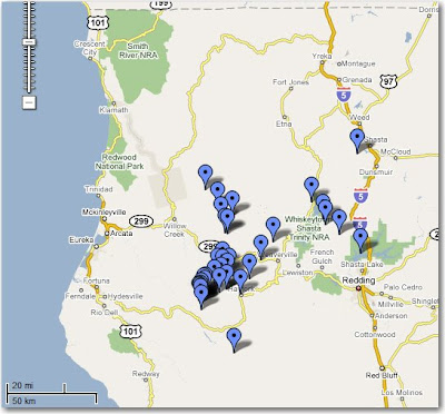
Below is a map showing the fires that have been reported just on the Shasta-Trinity NF in the last 24 hours. Those folks are going to be busy for a long time, unless the weather is very nice to them. A couple of the fires may be assists to other agencies, also dealing with new lightning fires.


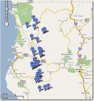
Here is a map showing the fires that have been reported on the Six Rivers NF in the last 24 hours.