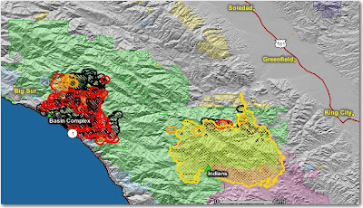
The Gallery fire south of Big Sur, part of the Basin complex, has been very active the last few days. If it has not already, it almost certainly will merge with the Basin fire just to the north. As of last night the combined acreage was 13, 550 for the two fires. Evacuations are still in effect for the Partington Ridge area, and Hwy. 1 remains closed. The fire has consumed 16 structures and is burning in the tracks of the 1977 Marble-Cone fire which scorched about 165,000 acres.
You have to think about the possibility of the Basin complex burning into the Indians fire which is about 5-7 miles away. There is a 20-39% probability this will happen by June 30 if there is no suppression action in that area. I imagine that would disappoint Bill Molumby's team that has struggled to obtain 71% containment of the 57,943 acre Indians fire. Having burned area on both sides of your fireline is disconcerting, to say the least.
The map below shows heat in red detected by satellites last night. Click on the map to see a larger version.


No comments:
Post a Comment