A local news article:
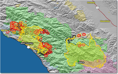
The Monterey County HeraldThis map shows that the Basin fire is quite a bit closer to Big Sur than it was two days ago. Most of the heat shown on the Indians fire is from their burnout along the Arroyo Seco drainage.
Article Last Updated: 06/29/2008 04:06:28 PM PDT
An evacuation advisory has been issued for the Palo Colorado Canyon area due to the northward spread of the Basin Complex fire Sunday.
The advisory is a precautionary notice warning residents to prepare to leave if necessary.
Basin Fire spokeswoman Tina Rose said Sunday that residents have been moving animals out of the area and many have made arrangements to stay elsewhere. More than 1,000 homes are threatened by the fire, which grew by more than 2,000 acres overnight.
"Most people are taking the advisory as seriously as we want them to," Rose said. "The movement of the fire is to the north, east and south."
Emergency broadcast announcements were aired on local radio and television stations Sunday morning.
The affected area includes Garrapatos Road, Redwood Estates, Green Ridge, Rocky Creek Ranch, Long Ridge, Rocky Creek Road and Ray Ridge Road.
The map below shows heat in red, orange, and black, detected by satellites, with the red areas being the most recently burned. The yellow lines are the perimeters uploaded by the incident management teams. Click on the map to see a larger version.


No comments:
Post a Comment