One of the aircraft is a twin-engine Piper Navajo that belongs to the Canadian contractor Range and Bearing, Inc. I did a little research and found out what they did this evening.

They took off from Redding, California (KRDD) and flew southeast about 50 miles. The parallel flight lines appear to be in the area of the BTU Lightning Complex and the Canyon complex. Then they landed at Redding and took off right away and flew northeast about 15 miles. They flew two circles in the area of a fire near Ingot then returned to Redding.
The map below shows the track of N144Z, the US Forest Service Citation, a jet, flying from Redding, to the Basin Complex and Indian fires (close to each other near Big Sur), then northeast to the area of the Oliver Complex fire southwest of Wawona. Then they headed northwest at 366 knots to some other fires southwest of Redding, then landed at Redding. They most likely dropped off the imagery, refueled, and departed again to fly other fires.

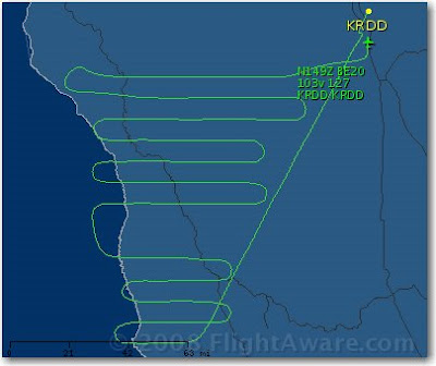
The last map, below, shows the track of N149Z, a twin turboprop King Air 200 that belongs to the U.S. Forest Service. It spent quite a lot of time southwest of Redding flying fires in the Ukiah area between highways 1 and 101, and then north to the Mendocino National Forest. Their flight plans called for them to land at Redding then depart for another 4-hour mission.

Maps, courtesy of flightaware.com


No comments:
Post a Comment