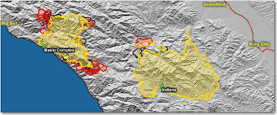
The red area on the northwest side of the Indians fire is most likely their firing operation along the Arroyo Seco river.
The map below shows heat, in red, orange, and black, detected by satellites last night, with the red areas being the most recently burned. The yellow lines are the perimeters uploaded by the incident management teams yesterday. Click on the map to see a larger version.

Basin complex update from the U.S. Forest Service last evening:

Firefighters continue to build and improve fireline throughout the east side of the Big Sur area and have been moving toward Manuel Peak. Dozer lines are being constructed along the North Coast Ridge Road south to Dolan Ridge to eventually meet up with the road from the Big Creek State Reserve. Structure protection engines remain in place along Partington Ridge, the North Coast Ridge Road and Highway 1. Today higher humidity at all elevations within the fire has moderated fire behavior due to wind changes.Indians fire update from the U.S. Forest Service last evening:
The fire did not expand significantly today. The firing operation continued eastward from the Arroyo Seco Campground south of the Arroyo Seco River and good progress was made due to the absence of smoke shading from the Basin Complex Fire and warmer, dryer weather. Good progress was made today improving line along the Rodeo Flats Trail.
Photo of Basin complex courtesy of Alana Cain


No comments:
Post a Comment