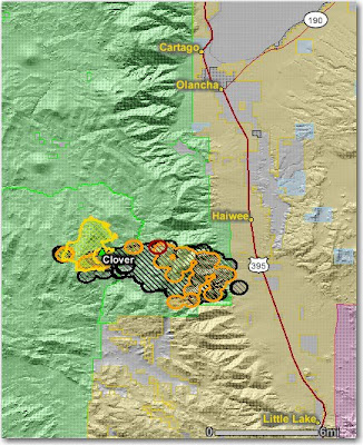
Here is a map of the Clover fire on the Sequoia and now Inyo National Forests in California showing the heat detected by satellites last night in red, orange, and black. The yellow line is the last perimeter uploaded by the incident management team a few days ago. It appears that is was less active yesterday than it was the day before when it made the big run towards Hwy. 395. It has burned 13,049 acres and is 10% contained. A second incident management team has been ordered to manage the portion of the fire on the east side of the Sierra crest.
Are Trading Simulators the Future of Financial Education?
-
In an increasingly complex financial landscape, where global events and
market trends can shift in the blink of an eye, the traditional methods of
financ...
2 weeks ago
No comments:
Post a Comment